25th Annual Black Diamond Fall Fundraising Party
Thursday, September 13; 6:00-10:00 PM; Black Diamond Parking Lot
25th Annual Black Diamond Fall Fundraising Party
Thursday, September 13; 6:00-10:00 PM; Black Diamond Parking Lot
| Advisory: Ogden Area Mountains | Issued by Toby Weed for Saturday - January 21, 2017 - 7:21am |
|---|

|
bottom line The avalanche danger is MODERATE and heightened avalanche conditions exist on steep wind-drifted upper and mid elevation slopes. Loose, long-running sluffs entraining light new snow are likely in steep terrain. Snow and strengthening west-northwest winds will cause the avalanche danger to rise and become more widespread today. Evaluate the snow and terrain carefully and avoid steep drifted slopes.
|
 |
special announcement If you sign up for AmazonSmile and designate the Utah Avalanche Center as your favorite charity, they will donate a portion of everything you spend to the UAC. It doesn't cost you a penny and we'd really appreciate the help. |
 |
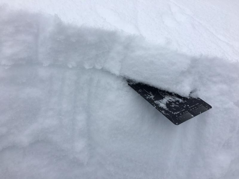
current conditions Temperatures in the Ogden mountains this morning are around 20 F. Southeast winds diminished late last night and are currently around 10 mph out of the southwest. The storm from yesterday didn't amount to a whole lot: Powder Mountain reports 2", and Monte Cristo 3". Unfortunately, a few inches of light new snow buried weak surface snow consiting of feathery surface hoar and sugary facets that developed during the recent high pressure. This new weak layer has potential to be a lingering problem. Good riding conditions on a few inches of new snow and re-crystallized powder can be found on wind-sheltered slopes, but variable crusts exist in sunny terrain.
Crystal card inserted in buried surface hoar layer on Cutler Ridge. |
 |
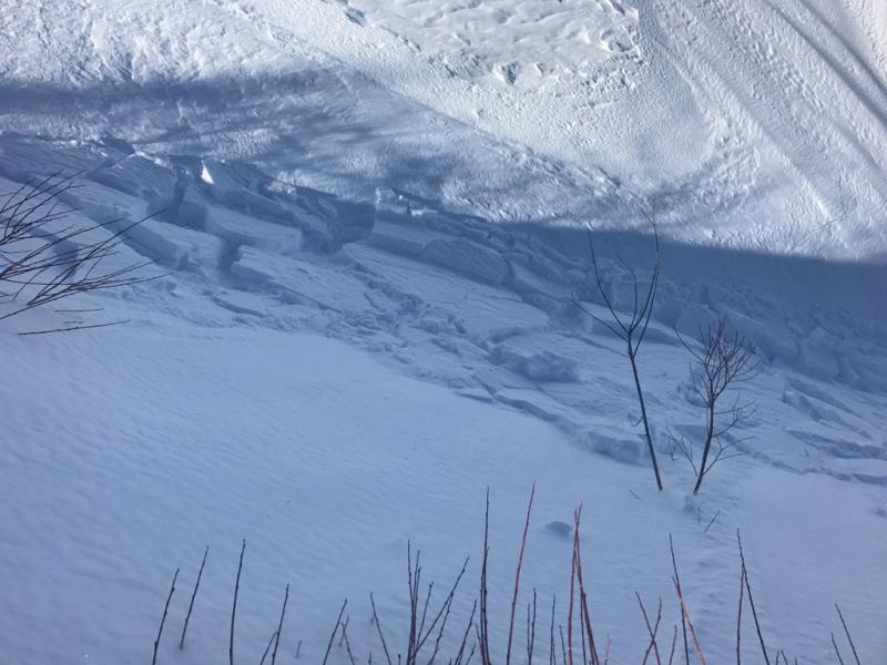
recent activity Very sensitive wind slabs quickly formed and were easy to trigger in the Cutler Ridge area on Wednesday.
Photo by Brian Smith of fresh winds slabs. |
| type | aspect/elevation | characteristics |
|---|

|
|
LIKELIHOOD
 LIKELY
UNLIKELY
SIZE
 LARGE
SMALL
TREND
 INCREASING DANGER
SAME
DECREASING DANGER
|
|
description
East winds yesterday evening created a heightened danger of wind slab avalanches in exposed upper and mid elevation terrain. Increasing and gusty northwest wind today will cause the danger to rise and become more widespread.
|
| type | aspect/elevation | characteristics |
|---|

|

|
LIKELIHOOD
 LIKELY
UNLIKELY
SIZE
 LARGE
SMALL
TREND
 INCREASING DANGER
SAME
DECREASING DANGER
|
|
description
A layer of weak facets exists above and below a thick rain crust from mid-December. This layer exists below 7500 feet and produced massive avalanches last week when it was stressed by heavy snowfall. Triggering an avalanche on this layer should be very hard to do today, but it's worth digging into the snow 3-4 feet to look for and assess this layer. A few inches of snow won't likely have an impact but another large storm could re-awaken this persistent problem. |
| type | aspect/elevation | characteristics |
|---|

|

|
LIKELIHOOD
 LIKELY
UNLIKELY
SIZE
 LARGE
SMALL
TREND
INCREASING DANGER
SAME
DECREASING DANGER
|
description
|
 |
weather The active weather pattern will continue across the region, with a series of weather systems crossing the area through the first half of next week. Expect 2 to 4 inches of snow today, and a high temperature at 8500' of 27 degrees F. South winds will veer from the west-northwest this morning. 1 to 3 inches of snow is expected tonight, with winds veering from the southwest and a low temperature around 12 F. 3 to 5 inches of snow is likely tomorrow, with a high temperature around 22 F and 15 to 20 mph south winds. The storm will intensify Sunday night and last through Monday, with strengthening south and west winds and 9 to 17 inches of snow possible by Monday evening. |
general announcements
|