25th Annual Black Diamond Fall Fundraising Party
Thursday, September 13; 6:00-10:00 PM; Black Diamond Parking Lot
25th Annual Black Diamond Fall Fundraising Party
Thursday, September 13; 6:00-10:00 PM; Black Diamond Parking Lot
| Advisory: Ogden Area Mountains | Issued by Evelyn Lees for Thursday - January 19, 2017 - 7:19am |
|---|

|
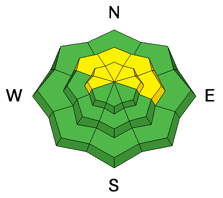
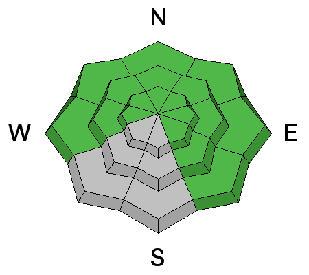
bottom line The avalanche danger is MODERATE on steep wind drifted upper elevation slopes, and MODERATE on wind drifted mid elevation slopes, too. These shallow new drifts will be cracky, and can be triggered from a distance. Out of the wind affected terrain, the avalanche danger is generally LOW, though larger dry sluffs can be triggered on steep shady slopes. As always, even a small avalanche can have bad consequences if you are in extreme terrain.
|
 |
special announcement Read a great new blog post by forecaster Drew Hardesty - Shame and the Social Contract |
 |
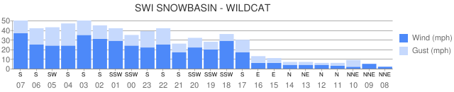
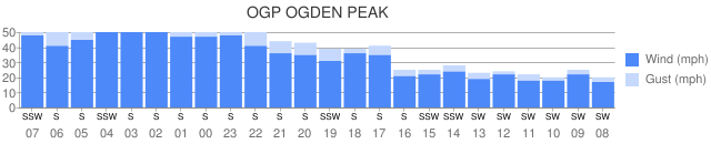
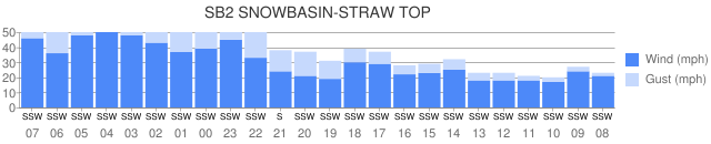
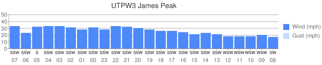
current conditions Skies are overcast in the Ogden area mountains, and light snow should start falling in the mountains soon as a weak storm slowly crosses the area. Ahead of the storm, the southerly winds have increased at most of the mid and upper elevation stations - 25 to 35 mph averages, with the highest stations averaging 50 mph or more. Temperatures are in the upper 20s to low 30s, and the temperature inversion has been scoured out, with trailheads now up to 20 degrees warmer than yesterday morning. Amid sun crusts and new wind slabs, soft faceted powder can still be found on shady, wind sheltered slopes. The Ogden wind graphs below read from right to left, with the most recent readings on the left.
|
 |
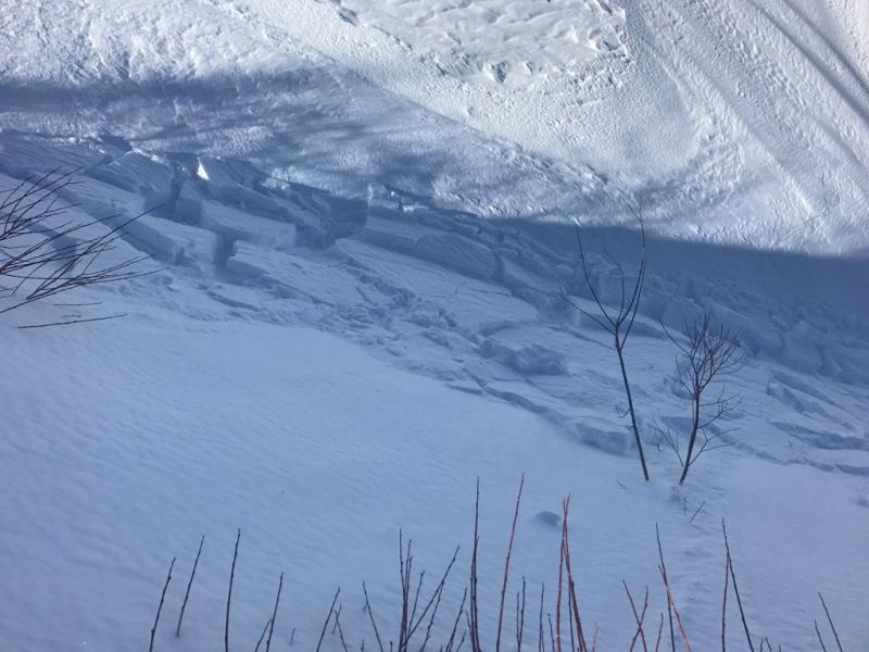
recent activity Ogden area mountains: along one strangely windy ridgeline, very sensitive wind slabs quickly formed and were easy to trigger. Photo by Brian Smith of new Ogden winds slabs from yesterday.
Yesterday, dry loose sluffs continued to be easy to trigger on the shady slopes and there were a few wet sluffs triggered on steep sunny slopes in the Salt Lake and Provo area mountains. These are the last of the wet loose sluffs we’ll see for a while |
| type | aspect/elevation | characteristics |
|---|

|
|
LIKELIHOOD
 LIKELY
UNLIKELY
SIZE
 LARGE
SMALL
TREND
 INCREASING DANGER
SAME
DECREASING DANGER
|
|
description
A layer of weak facets exists above and below a thick rain crust from mid-December. This layer exist below 7500 feet and produced massive avalanches last week when it was stressed by heavy snowfall. Triggering an avalanche on this layer should be hard to do today, but it's worth digging into the snow 3-4 feet to look for and assess this layer. |
| type | aspect/elevation | characteristics |
|---|

|
|
LIKELIHOOD
 LIKELY
UNLIKELY
SIZE
 LARGE
SMALL
TREND
 INCREASING DANGER
SAME
DECREASING DANGER
|
|
description
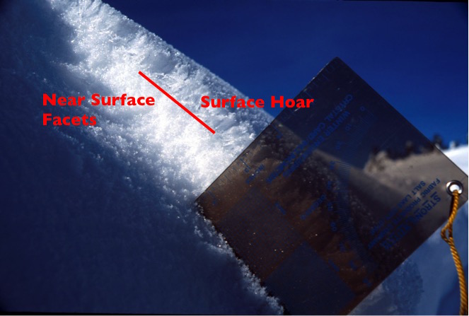
The current stronger winds are a good thing – hopefully they batter down and destroy some of our weak surface hoar. But the winds have also created sensitive new drifts of snow along ridgelines, some of which are still sitting on facets. While the new cracky drifts will be shallow, they will be easy to trigger and you may even be able to trigger them remotely from a distance. They will be large enough to take you for a ride in steep terrain. The old photo below shows similar set up to what we had yesterday on the snow surface on shady slopes – surface hoar sitting on a thick layer on small faceted snow grains. Even where winds destroy the fragile surface hoar, some of the facets below may persist, providing a weak layer for new wind drifts and new snow. Discovering the distribution of any preserved surface hoar or near surface facets will be important
|
| type | aspect/elevation | characteristics |
|---|

|
|
LIKELIHOOD
LIKELY
UNLIKELY
SIZE
 LARGE
SMALL
TREND
INCREASING DANGER
SAME
DECREASING DANGER
|
|
description
In wind sheltered, shady terrain, I expect some of the weak surface snow to get capped by new snow. You will continue to be able to trigger the predictable dry loose sluffs today, and they will be larger than the past few days if you’re in a spot where the new snow adds up to the forecast 3 to 6”. The sluffs will entrain snow down slope, and be large enough to catch and carry you in continuously steep terrain. |
 |
weather A weak, slow moving storm will bring snow to the mountains today and tonight. 3-6” of snow is possible today, with another 1 to 3” tonight. We should see the strongest winds this morning, with averages to 30 mph, and gusts to 50. The winds should shift to the southwest later this morning, and decrease, with average speeds below 20 mph. Temperatures will remain near 20 at 10,000’. Looking into the future, a weak storm Friday night into Saturday will bring a few more inches of snow, with a potentially stronger storm Monday into Tuesday. |
general announcements
|