25th Annual Black Diamond Fall Fundraising Party
Thursday, September 13; 6:00-10:00 PM; Black Diamond Parking Lot
25th Annual Black Diamond Fall Fundraising Party
Thursday, September 13; 6:00-10:00 PM; Black Diamond Parking Lot
| Advisory: Ogden Area Mountains | Issued by Mark Staples for Wednesday - January 18, 2017 - 7:18am |
|---|


|
bottom line The avalanche danger is LOW on all aspects and elevations, and today is a great one to be in the mountains with warm temperatures and light winds. Avalanche conditions are generally safe, but avalanches are possible in isolated areas.
|
 |
special announcement Read a great new blog post by forecaster Drew Hardesty - Shame and the Social Contract |
 |
current conditions This morning temperatures are warmer the higher you go. Temperatures are in the low teens F at low elevations and in the mid to high 20's F above 8000 feet. With an approaching storm winds shifted to the W overnight and increased at ridgetops blowing 15-20 mph. Below ridgetops, winds are blowing 2-5 mph. On sunny aspects the snow surface has become wet each day and refrozen each night. On shaded aspects, the snow surface has remained dry but has weakened significantly. It contains a mix of small faceted crystals and surface hoar crystals which create "loud powder". Observers have noted these conditions throughout the Wasatch Range, and Craig Gordon found similar snow surface conditions yesterday in the Uinta Mountains. Watch his video below. |
 |
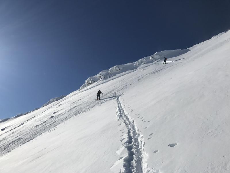
recent activity With people enjoying beautiful weather and generally safe avalanche conditions, they have been riding slopes throughout the Wasatch Range. A group of skiers in the Central Wasatch Range triggered a few wind slabs that formed 2-3 days ago. Low danger doesn't mean No danger. These seem to be mostly isolated problems and easy to identify and manage. Photo below of a wind slab that broke 7 inches deep and 60 feet wide at 11,000 feet in Hogum Fork on a S aspect (recent winds were from the N).
|
| type | aspect/elevation | characteristics |
|---|

|
|
LIKELIHOOD
 LIKELY
UNLIKELY
SIZE
 LARGE
SMALL
TREND
 INCREASING DANGER
SAME
DECREASING DANGER
|
|
description
A layer of weak facets exists above and below a thick rain crust from mid-December. This layer exist below 7500 feet and produced massive avalanches last week when it was stressed by heavy snowfall. Triggering an avalanche on this layer should be hard to do today, but it's worth digging into the snow 3-4 feet to look for and assess this layer. |
| type | aspect/elevation | characteristics |
|---|

|
|
LIKELIHOOD
LIKELY
UNLIKELY
SIZE
 LARGE
SMALL
TREND
INCREASING DANGER
SAME
DECREASING DANGER
|
|
description
Wind slabs formed 2-3 days ago from N winds. S and SW winds may form shallow wind slabs today. Look for these wind slabs under ridges or cross loaded gullies. They have a smoother and rounder appearance than other snow. Don't take anything for granted if riding in very steep or exposed terrain where the consequences of a very small slide can be deadly. I often try to find a way to ride around obvious wind slabs and avoid the problem altogether. Watch for a few other avalanche problems including:
|
| type | aspect/elevation | characteristics |
|---|

|

|
LIKELIHOOD
LIKELY
UNLIKELY
SIZE
 LARGE
SMALL
TREND
INCREASING DANGER
SAME
DECREASING DANGER
|
|
description
The snow surface today could become a weak layer in the future. Warm sunny days and clear cold nights weaken the snow surface and form surface hoar (a fancy name for frost that forms on the snow). Ways to spot these facets and surface hoar are:
Will it be a problem in the future? It's hard to say and highly dependent on the weather. This potential weak layer is easily destroyed by strong sunshine and/or strong winds. If the next storm arrives with light winds, this weak snow can be preserved and capped by new snow. If that happens, it will become a problem once a slab forms on top. Watch the video below of this weak surface snow from B. Smith near Ogden. |
 |
weather Despite some approaching clouds in Nevada this morning, skies will be mostly sunny today. Temperatures will climb into the upper 30's F. Winds may increase some and blow 15 mph from the W by later today. A series of small storms will arrive on Thursday. None should bring significant snow; however, 5-10 inches is possible over the entire storm period of 4-5 days. |
general announcements
|