25th Annual Black Diamond Fall Fundraising Party
Thursday, September 13; 6:00-10:00 PM; Black Diamond Parking Lot
25th Annual Black Diamond Fall Fundraising Party
Thursday, September 13; 6:00-10:00 PM; Black Diamond Parking Lot
| Advisory: Ogden Area Mountains | Issued by Trent Meisenheimer for Tuesday - January 17, 2017 - 5:41am |
|---|

|
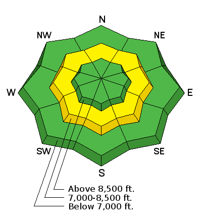
bottom line The avalanche danger is MODERATE on steep mid elevation aspects around the compass. Where there is a possibility of triggering a deep slide, failing just above the December ice layer. At upper elevations you'll find a LOW avalanche danger, avoid pillows of rounded, smooth snow and be alert for cracking, indicating you have found a drift. Huge cornices are still sensitive and breaking back further than expected.
|
 |
special announcement Be sure to catch Brody Leven this Thursday night at the Utah Adventure Journal speaker series at Snowbird. The price of admission is free - hard to beat. We have lots of events and classes coming up - check out the calendar of events here. There is a great new blog post by forecaster Drew Hardesty - Shame and the Social Contract |
 |
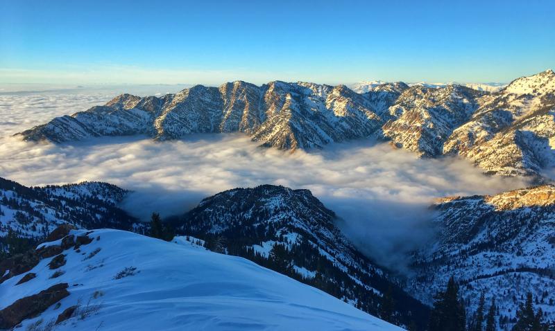
current conditions Should be another beautiful sunny day in the mountains. The inversion over northern Utah will continue to trap the fog, haze and cold air down low. Trailhead temperatures are in the single digits, while the upper elevations are in the mid to upper teens. Winds overnight remained calm and generally from the north with even the highest anemometers on Ogden peak only reading 10-15 mph with the occasional gust into the 20's. Sun kissed slopes offer breakable crusts, while the shady slopes have excellent shallow loud powder. Above the inversion - Photo: Trent Meisenheimer
|
 |
recent activity Yesterday backcountry travelers were still reporting sensitive wind slabs along upper elevation ridgelines. These wind slabs were generally about thirty feet wide and up to a foot deep. See Aaron Rice's observation from the central Wasatch. Ogden area mountains: A person on Sunday January 15th released a large cornice along a high ridge line with debris deep enough to bury a person. Provo area mountains on Sunday January 15th: Riders triggered a 3-foot deep, 80-foot wide hard slab mid slope in the northwest chute of Box Elder peak. One person was carried a distance before arresting on the bed surface. This was at 10,200 feet on a northwest-facing slope. |
| type | aspect/elevation | characteristics |
|---|

|

|
LIKELIHOOD
 LIKELY
UNLIKELY
SIZE
 LARGE
SMALL
TREND
 INCREASING DANGER
SAME
DECREASING DANGER
|
|
description
From Paige Pagnucco & team from the 15th: Persistent weak layers have been reactivated by the sheer volume and added water weight of the recent new snow. The tipping point seemed to occur Wednesday night on the 11th, when numerous destructive avalanches up to 5' deep released naturally on low and mid elevation, north through southeast facing slopes. They consistently failed on faceted weak snow just above the mid-December rain crust. These types of avalanches are not to be trifled with as they are low probability but high consequence - they can lure you way out onto them before releasing. Taking a ride will lead to a bad outcome. You can easily avoid this problem by sticking to slopes less than 30 degrees and giving the snowpack time to adjust to the new load. Sight seeing is still amazing.... photos by Brandt of Willard Peak slide. Observation found here.
|
| type | aspect/elevation | characteristics |
|---|

|

|
LIKELIHOOD
 LIKELY
UNLIKELY
SIZE
LARGE
SMALL
TREND
 INCREASING DANGER
SAME
DECREASING DANGER
|
|
description
Sensitive wind slabs that formed along ridgelines will remain a concern for today. Identify and avoid the rounded, cracky drifts of harder snow. Even yesterday, the few old wind drifts triggered were large enough to take you for a ride in steep terrain. Brody Leven sent me a video last that demonstrates effective ski cuts in steep terrain. Did I mention he was speaking this Thursday night at Snowbird? |
| type | aspect/elevation | characteristics |
|---|

|
|
LIKELIHOOD
LIKELY
UNLIKELY
SIZE
LARGE
SMALL
TREND
INCREASING DANGER
SAME
DECREASING DANGER
|
|
description
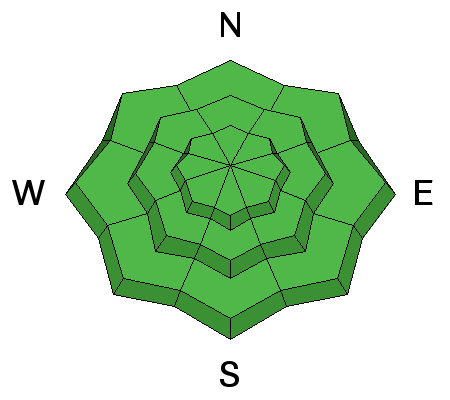
In general, we have a stable snow pack and a LOW avalanche danger. But avalanches can still be triggered in isolated places, and even a small slide can have bad consequences if you are in serious terrain. Evaluate steep terrain carefully. Are you above a cliff or in continuous steep terrain where you could go for a long ride? Or be pushed into trees or stopped on a bench where the snow could pile up? Huge cornices are still hanging along the ridgelines, and could break back much further than expected – onto what looks like the flat ridge line. Even if it doesn’t trigger a slide, you could be injured in the fall. Loose snow sluffs can be triggered in the weakening surface snow and are getting large enough to knock you off balance. Wet loose sluffs – a few isolated wet sluffs could be triggered today in steep, sunny terrain. Avoid being in steep sunny terrain during the heat of the day. Wild card – In very isolated places, generally in the high alpine terrain, a deeper slab avalanche could be triggered, perhaps in a shallow rocky snowpack area or on a more heavily wind drifted slope. |
 |
weather It will be another glorious sunny day in the mountains with temperatures rising into the low 30's at 8500' with upper elevation 10,000' temps rising into the mid 20's. Winds will remain light and generally from the north with speeds of 10-15 mph with the occasional gust into the 20's. Looking ahead - We have a series of small storms expected to impact the state starting on Thursday. None of these storms are looking impressive at this time. However, it will bring a nice refresher to the mountains with 5-10" of new snow possible over a few day period. |
general announcements
|