25th Annual Black Diamond Fall Fundraising Party
Thursday, September 13; 6:00-10:00 PM; Black Diamond Parking Lot
25th Annual Black Diamond Fall Fundraising Party
Thursday, September 13; 6:00-10:00 PM; Black Diamond Parking Lot
| Advisory: Ogden Area Mountains | Issued by Evelyn Lees for Monday - January 16, 2017 - 7:20am |
|---|

|
bottom line The avalanche danger is MODERATE on steep wind drifted upper elevation slopes where new wind drifts will form today. Avoid pillows of rounded, smooth snow and be alert for cracking, indicating you have found a drift. The huge cornices are still sensitive and breaking back further than expected. There is also a MODERATE danger of triggering a deep slide at the mid and lower elevations, failing just above the December ice layer.
|
 |
special announcement New blog post - Shame and the Social Contract |
 |
current conditions High pressure strengthening over northern Utah has brought clear skies and colder temperatures to the mountains this morning. Temperatures are in the teens at the mid and upper elevations, with single digits in the cold canyon bottoms. Winds have increased – averaging 5 to 10 mph at the mid elevations, with Mt Ogden averaging 25 to 30 mph in the past few hours. Sunny slopes sport breakable crusts, but there is excellent shallow loud powder on wind sheltered shady slopes. |
 |
recent activity Ogden area mountains: Again, a person released a large cornice along a high ridge line with debris deep enough to buy a person. Provo area mountains: A 3-foot deep, 80-foot wide hard slab was triggered mid slope in the northwest chute of Box Elder peak. One person was carried a distance before arresting on the bed surface. This was at 10,200 feet on a northwest-facing slope. Salt Lake and Park City area mountains: Several small wind slabs were triggered, in upper Red Pine and in Wolverine Chutes. A few small dry and wet loose sluffs were also reported. Explosive work was able to pry out a 3 foot deep by 80’ wide slide to the ground on a NW facing slope at 10,600’, in a very shallow snowpack area. Travelers in Broads Fork and Mill B noted the evidence of a widespread avalanche cycle from last week. |
| type | aspect/elevation | characteristics |
|---|

|
|
LIKELIHOOD
 LIKELY
UNLIKELY
SIZE
 LARGE
SMALL
TREND
 INCREASING DANGER
SAME
DECREASING DANGER
|
|
description
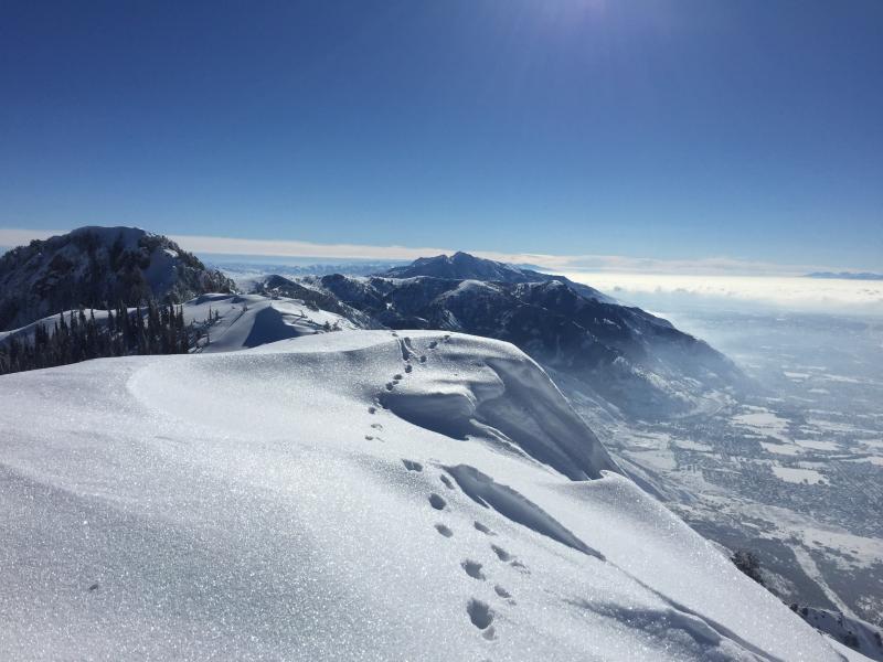
From Drew yesterday: Persistent weak layers have been reactivated by the sheer volume and added water weight of the recent new snow. The tipping point seemed to occur Wednesday night when numerous destructive avalanches up to 5' deep released naturally on low and mid elevation, north through southeast facing slopes. They consistently failed on faceted weak snow just above the mid-December rain crust. These types of avalanches are not to be trifled with as they are low probability but high consequence - they can lure you way out onto them before releasing. Taking a ride will lead to a bad outcome. You can easily avoid this problem by sticking to slopes less than 30 degrees and giving the snowpack time to adjust to the new load. Sight seeing is still amazing.... photos by Brandt of Rodeo Ridge slide
|
| type | aspect/elevation | characteristics |
|---|

|
|
LIKELIHOOD
 LIKELY
UNLIKELY
SIZE
LARGE
SMALL
TREND
 INCREASING DANGER
SAME
DECREASING DANGER
|
|
description
With the increase in wind speeds at the upper elevations, new sensitive wind slabs forming along ridge lines will be the number one concern today. Identify and avoid the rounded, cracky drifts of harder snow. Even yesterday, the few old wind drifts triggered were large enough to take you for a ride in steep terrain. |
| type | aspect/elevation | characteristics |
|---|

|
|
LIKELIHOOD
LIKELY
UNLIKELY
SIZE
LARGE
SMALL
TREND
INCREASING DANGER
SAME
DECREASING DANGER
|
|
description
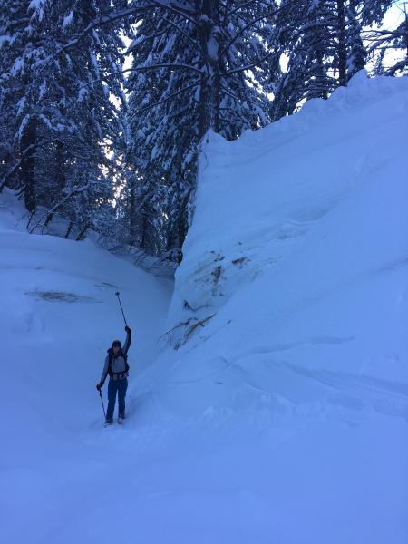
In general, we have a stable snow pack and a LOW avalanche danger. But avalanches can still be triggered in isolated places, and even a small slide can have bad consequences if you are in serious terrain. Evaluate steep terrain carefully. Are you above a cliff or in continuous steep terrain where you could go for a long ride? Or be pushed into trees or stopped on a bench where the snow could pile up? Huge cornices are still hanging along the ridgelines, and could break back much further than expected – onto what looks like the flat ridge line. Even if it doesn’t trigger a slide, you could be injured in the fall. Loose snow sluffs can be triggered in the weakening surface snow and are getting large enough to knock you off balance Wet loose sluffs – a few isolated wet sluffs could be triggered today in steep, sunny terrain Wild card – In very isolated places, generally in the high alpine terrain, a deeper slab avalanche could be triggered, perhaps in a shallow rocky snowpack area or on a more heavily wind drifted slope. This traveler a little too close to the cornice edge.... Also note the sparkling surface hoar Brandt photo
|
 |
weather High pressure remains firmly in control, and the mountains will have beautiful clear sunny skies, while the lower canyons will be bathed in fog and stratus. The north to northeasterly winds increased at the upper elevations, and could average to 25 to 30 with gusts in the 30s. Speeds at the mid and lower elevations should remain less than 15 mph at most stations. Temperatures will be a bit cooler today – near 30 at 8000’, and in the low 20s along the high ridge lines. A series of storms Thursday through Monday will bring periods of snow to the mountains. |
general announcements
|