25th Annual Black Diamond Fall Fundraising Party
Thursday, September 13; 6:00-10:00 PM; Black Diamond Parking Lot
25th Annual Black Diamond Fall Fundraising Party
Thursday, September 13; 6:00-10:00 PM; Black Diamond Parking Lot
| Advisory: Ogden Area Mountains | Issued by Paige Pagnucco for Friday - January 13, 2017 - 5:27am |
|---|

|
bottom line The avalanche danger is CONSIDERABLE, particularly for persistent slab avalanches in low and mid elevation terrain. Dangerous avalanche conditions exist - careful snowpack evaluation, cautious route-finding and conservative decision making are essential for safe travel today.
|
 |
special announcement Avalanche Education in the Ogden mountains CANCELLED!!! BUT WE WILL RESCHEDULE ...Friday January 13th – 12:30pm – FREE Beacon Clinic – POW! day at Powder Mountain STILL ON! Friday January 13th – 5-8pm – Companion Rescue Fundamentals Class (registration is required) Location: Snowbasin Ski Resort STILL ON! Friday January 13th – 6pm – FREE Know Before You Go Avalanche Awareness Presentation Location: AD Triple S Motorsports, West Haven, UT
|
 |
current conditions The storm is finally over! I say that in the nicest possible way, but, it will be good to give the snowpack time to adjust to the 8-9" of total water weight added this week as well as maybe get a chance to examine the avalanche "damage." Riding conditions are quite good with the recent cooler temps and calm wind. Observers in the Cutler Ridge area noted great powder conditions on lower angle slopes across most aspects. The snowpack is stabilizing though, with the magnitude of the recent storm, it'll be wise to stay conservative. As we head into a busy holiday weekend, with many backcountry travelers anxious to enjoy all the new snow, there will be lots more potential triggers. Conditions were very dangerous just a day and a half ago and, though the snow appears to be stabilizing, it is still a gradual process. More triggers + considerable danger = higher potential for avalanche accidents. Keep your slope angles low today to avoid this issue. This morning it is 21 F at Ben Lomond (8000'), 18 F at James Peak (9425'), and 19 F at Monte Cristo (8960'). Southeasterly winds were fairly mild overnight with only a few ridgetop gusts in the 15-20 mph range. Some areas received an inch or two of snow late yesterday.
|
 |
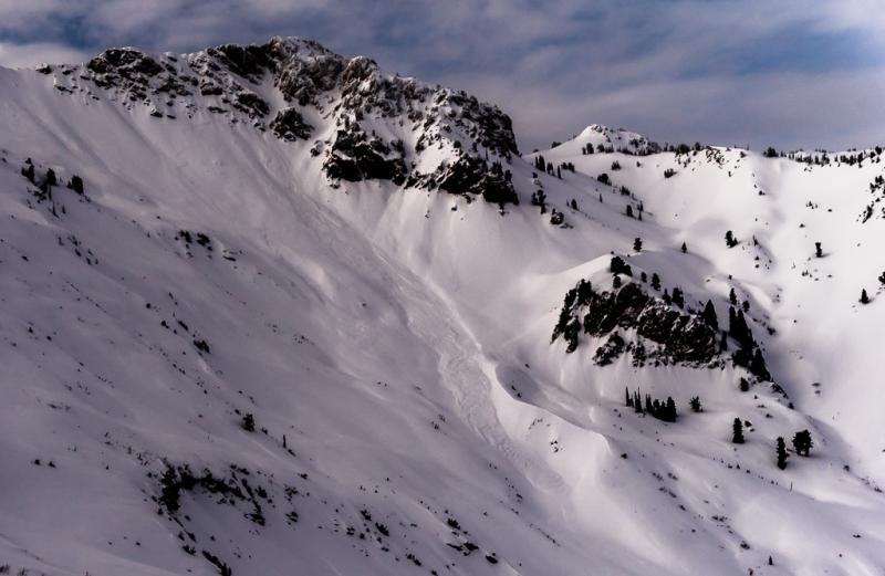
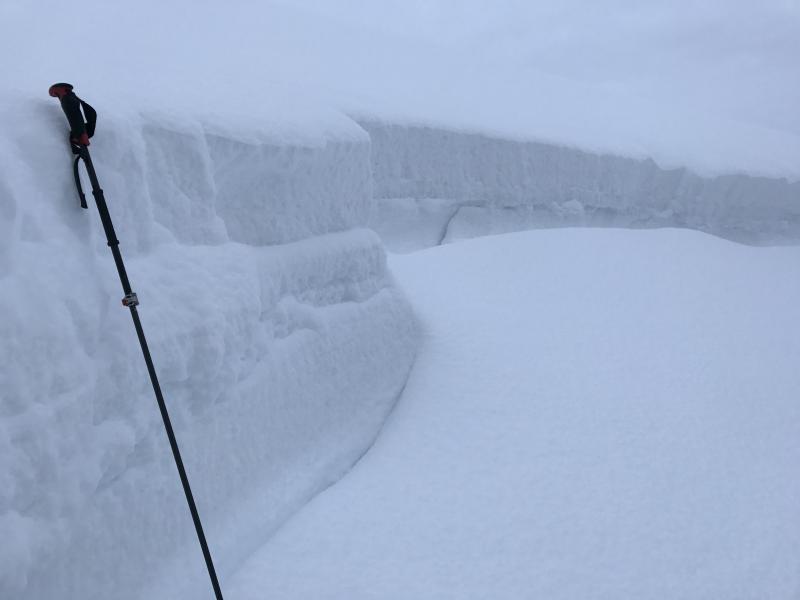
recent activity A widespread natural avalanche cycle occurred overnight Wednesday-Thursday in the Ogden zone. Numerous persistent slab avalanches up to 5' deep released on low and mid-elevation slopes. Many of these were in the Cutler Ridge area while one was reported in the backcountry near Snowbasin. Snowfall intensified overnight which likely overloaded the persistent weak layers present just above the mid-December rain crust and caused them to fail. Crowns of Cutler Ridge natural avalanches. (photo:Hardesty/Wewer)
One moderate size storm slab avalanche was observed on the southeast face of Willard Peak. (photos: Hardesty/Wewer) |
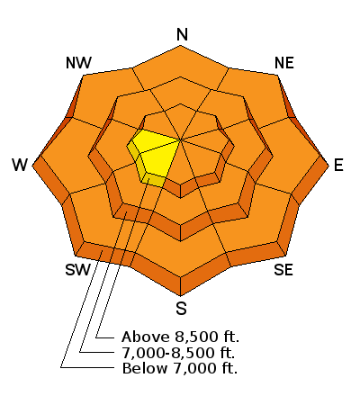
| type | aspect/elevation | characteristics |
|---|

|
|
LIKELIHOOD
 LIKELY
UNLIKELY
SIZE
 LARGE
SMALL
TREND
 INCREASING DANGER
SAME
DECREASING DANGER
|
|
description
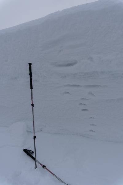
Persistent weak layers have been reactivated by the sheer volume and added water weight of the recent new snow. The tipping point seemed to occur Wednesday night when numerous deep, destructive avalanches released naturally on low and mid elevation, north through southeast facing slopes. They consistently failed on faceted weak snow just above the mid-December rain crust. These types of avalanches are not to be trifled with - they can lure you way out onto them before releasing. Taking a ride will lead to a bad outcome. You can easily avoid this problem by sticking to slopes less than 30 degrees and giving the snowpack a few more days to adjust to the new load. *Snowmobilers should pay particular attention today - snowmobiles weigh much more than a skier and, with the force they exert on the snowpack, might have an easier time triggering a deeper avalanche. Photos of natural avalanche cycle 1/11-1/12 near Cutler Ridge (photos: Hardesty/Wewer)
The deep crown of one of many natural avalanches in the Cutler Ridge area. (photo: M. Henderson) |
| type | aspect/elevation | characteristics |
|---|

|

|
LIKELIHOOD
 LIKELY
UNLIKELY
SIZE
 LARGE
SMALL
TREND
 INCREASING DANGER
SAME
DECREASING DANGER
|
|
description
The storm snow itself is stabilizing quickly with not very much activity reported. The snow is sitting right side up with lighter density surface conditions looking like real Utah powder. We did just get alot of snow though over the last week which theoretically needs time to settle and strengthen. There are weak layers within the new snow that may still be triggered with the weight of a skier. Look for red flags like cracking or collapsing in the upper snowpack - these are obvious signs to stay on slopes less than 30 degrees. At upper elevations, you might see some loose snow sluffs in the upper layers where the snow is drier. At lower elevations, where temperature highs are forecast to reach 32 F, keep on eye out for wet activity, like rollerballs, which indicates increasing instability. |
| type | aspect/elevation | characteristics |
|---|

|
|
LIKELIHOOD
LIKELY
UNLIKELY
SIZE
LARGE
SMALL
TREND
INCREASING DANGER
SAME
DECREASING DANGER
|
|
description
Cornices built up during the strong storm winds will still be sensitive and should be avoided. They may break back further than you expect. The weight of a cornice dropping on to a slope below may enough to trigger a subsequent avalanche. Winds have been relatively calm over the past 24 hours though they did crank during the storm. Most wind slabs will be at high elevations near ridgelines as well as other exposed terrain features like sub-ridges and gullies. Some of these wind slabs may be hard to see under the new snow so pay close attention to changes underfoot - avoid hollow-sounding or chalky feeling snow on steep slopes. |
 |
weather The weather for the holiday weekend looks just about perfect - cold nights, calm winds and sunny days. We'll have a few lingering clouds today before high pressure sets up until possibly mid-week. Temperatures in the mountains are forecast to reach the mid to high 20's F. |
general announcements
|