25th Annual Black Diamond Fall Fundraising Party
Thursday, September 13; 6:00-10:00 PM; Black Diamond Parking Lot
25th Annual Black Diamond Fall Fundraising Party
Thursday, September 13; 6:00-10:00 PM; Black Diamond Parking Lot
| Advisory: Ogden Area Mountains | Issued by Evelyn Lees for Thursday - January 12, 2017 - 7:36am |
|---|

|
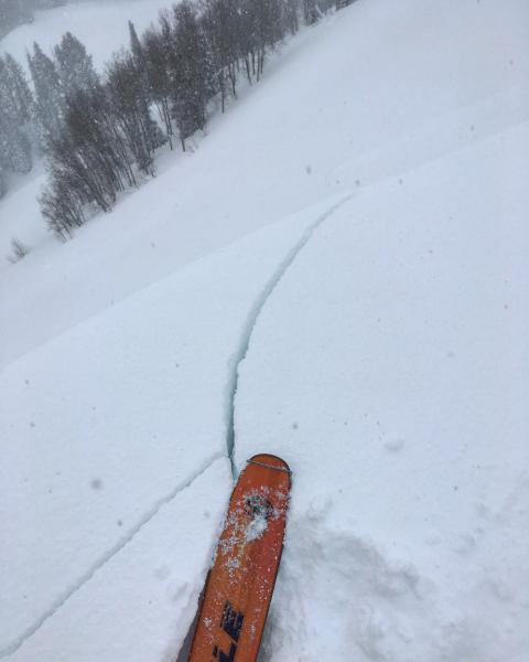
bottom line The avalanche danger is HIGH on steep upper elevation slopes where wind drifts, cornices and new snow avalanches can be easily triggered by a person. The avalanche danger is CONSIDERABLE on mid and low elevation slopes. Natural avalanches may occur this afternoon if we get a period of heavy snowfall. Travel in avalanche terrain is not recommended. If you do venture into the backcountry, you need expert snowpack and terrain evaluation skills and conservative decision-making. Look at a map, measure your slope angles and stay off of and out from under slopes steeper than about 30 degrees. Low angle turning and riding is fast, so you can still have fun out of the steep avalanche terrain.
|
 |
avalanche warning THE FOREST SERVICE UTAH AVALANCHE CENTER IN SALT LAKE CITY HAS ISSUED A BACKCOUNTRY AVALANCHE WARNING * TIMING...THE WARNING REMAINS IN EFFECT THROUGH 6 AM MST FRIDAY. * AFFECTED AREA...THE MOUNTAINS OF NORTHERN UTAH TO INCLUDE...THE WASATCH RANGE...THE BEAR RIVER RANGE...THE MOUNTAINS OF SOUTHEAST IDAHO...THE WESTERN UNITAS...AND THE MANTI-SKYLINE PLATEAU. * AVALANCHE DANGER...THE AVALANCHE DANGER IS HIGH. * REASON/IMPACTS...NUMEROUS DAYS OF HEAVY SNOWFALL AND STRONG WINDS HAVE CREATED WIDESPREAD AVALANCHE DANGER. BOTH HUMAN TRIGGERED AND NATURAL AVALANCHES ARE LIKELY. STAY OFF OF AND OUT FROM UNDER SLOPES STEEPER THAN 30 DEGREES. |
 |
special announcement Avalanche Education in the Ogden mountains Thursday January 12th – 6pm – Introduction to Avalanches Class (registration is required) Location: Amer Sports and Snowbasin (Field Day - Saturday January 14th) Friday January 13th – 12:30pm – FREE Beacon Clinic – POW! day at Powder Mountain Location: Main parking lot at Powder Mountain Friday January 13th – 5-8pm – Companion Rescue Fundamentals Class (registration is required) Location: Snowbasin Ski Resort Friday January 13th – 6pm – FREE Know Before You Go Avalanche Awareness Presentation Location: AD Triple S Motorsports, West Haven, UT Snowbird Speaker Series: Douglas Stoup is the world's leading polar adventurer and has skied to the North and South Poles more than anyone on the planet. He will be speaking at the Wildflower Lounge at Snowbird at 6 pm on Thursday night, Jan 12 with a raffle to benefit the Utah Avalanche Center. Details here. |
 |
current conditions The storm backed off a bit, with the Ogden area mountains receiving "only" 5 to 6 inches of snow overnight, putting 24-hour totals anywhere from 8 to 21”. Skies are overcast this morning, temperatures are in the low to mid 20s and the winds are very light, averaging less than 15 mph even across the higher peaks. For the 5-day storm totals since Saturday, the 7th, I’m focusing on inches of water, not snow. The Ogden area mountains are very variable, but with the largest water numbers around Ben Lomond and Powder mountain – 8 to 9” of water. The Provo area mountains are on the high end, with 5-7” of water in their storm total. The Cottonwoods and Park City area mountains have received 2 ½ to 4 ½ inches of water weight, with upper Big Cottonwood Canyon significantly more. |
 |
recent activity Yesterday, a very close call involving a group of motorized assisted snowboarders occurred in the Smith-Moorehouse area in the Uintas. Two snowboarders triggered a large slide, were buried, recovered, and sustained very serious injuries, but at the end of the day survived. Craig and Trent will visit the site today. Avalanche reduction work at the Ogden resorts and for the highway triggered numerous large avalanches, which mostly seemed to be new snow, especially in the areas that received the most snow. |
| type | aspect/elevation | characteristics |
|---|

|
|
LIKELIHOOD
 LIKELY
UNLIKELY
SIZE
 LARGE
SMALL
TREND
 INCREASING DANGER
SAME
DECREASING DANGER
|
|
description
Days of strong winds have created huge cornices along the ridge lines and deep drifts of snow on many at mid and upper elevation slopes. The drifts are widespread - along the ridge lines, in open bowls, at mid slope break overs and cross loaded along sub ridges – and becoming more stubborn. If you trigger one, it will be deep and dangerous. Perhaps 3 to 4 feet deep. Also, keep a sharp eye on today’s southeasterly winds – while forecast to be very light, if speeds increase, the avalanche danger will increase.
|
| type | aspect/elevation | characteristics |
|---|

|
|
LIKELIHOOD
 LIKELY
UNLIKELY
SIZE
 LARGE
SMALL
TREND
 INCREASING DANGER
SAME
DECREASING DANGER
|
|
description
Even out of the wind-affected terrain, triggering a new snow slab avalanche 1 to 2 feet deep on one of the mid-storm weak layers is possible on steep slopes. Buried low-density snow or graupel could serve as a weak layer. Sluffs can also be triggered, and could occur naturally during periods of heavy snowfall this afternoon |
| type | aspect/elevation | characteristics |
|---|

|
|
LIKELIHOOD
 LIKELY
UNLIKELY
SIZE
 LARGE
SMALL
TREND
INCREASING DANGER
SAME
DECREASING DANGER
|
|
description
At the mid and low elevations, there is a very variable rain crust, which in places is poorly bonded to facets beneath it in places. This layering is involved in some of the slides that closed Logan Canyon yesterday, and any slide breaking by this ice crust will be deep. A smaller new snow slide might be able to trigger a deeper slide on this layering. Also, the sheer weight of all the recent snow has probably triggered a few deeper slides, and a few more could still occur. Just too much snow, too fast, for the snowpack to adjust everywhere. |
 |
weather The models have broadened the extent of the next wave of snow, with heavier precipitation now expected in northern Utah. Snow should increase by late morning, becoming heavier this afternoon with an additional 4 to 8 inches possible. Temperatures will warm into the mid to upper 20s at 8,000’. The southeasterly winds are forecast to remain light, averaging 5 to 15 mph at all elevations, with gusts less than 25 mph. Snow is expected to become showery this evening through Friday, with a few more inches of snow possible tonight and tomorrow. Winds will remain light, and shift to the southwest. A dry northerly flow sets up this weekend as high pressure builds in from the west. Another potentially warm, wet event looks on tap for the latter half of next week. |
general announcements
|