25th Annual Black Diamond Fall Fundraising Party
Thursday, September 13; 6:00-10:00 PM; Black Diamond Parking Lot
25th Annual Black Diamond Fall Fundraising Party
Thursday, September 13; 6:00-10:00 PM; Black Diamond Parking Lot
| Advisory: Ogden Area Mountains | Issued by Greg Gagne for Wednesday - January 11, 2017 - 6:56am |
|---|

|
bottom line There is an avalanche warning today with strong winds and snowfall expected throughout the day. The avalanche danger is HIGH at mid and upper elevations, and CONSIDERABLE at lower elevations. Travel in avalanche terrain is not recommended today. For those that need to safely remedy their powder fever, Ogden Valley skiers and riders are blessed with world-class resorts with cracker-jack snow safety teams. For those that choose to venture into the backcountry today, avoid travel on and below slopes steeper than 30 degrees, and avoid avalanche runout zones. Pay attention to rapidly changing avalanche and weather conditions. Days such as today often remind me of what my mentor Tom Kimbrough once said: "Everyone knew you were an avalanche expert, except the avalanche."
|
 |
avalanche warning THE FOREST SERVICE UTAH AVALANCHE CENTER IN SALT LAKE CITY HAS CONTINUED THE BACKCOUNTRY AVALANCHE WARNING. * TIMING...THROUGH 6AM THURSDAY * AFFECTED AREA...THE MOUNTAINS OF NORTHERN UTAH, TO INCLUDE THE WASATCH RANGE, THE BEAR RIVER RANGE AND THE MOUNTAINS OF SOUTHEAST IDAHO, THE WESTERN UINTAS, AND THE MANTI-SKYLINE PLATEAU. * AVALANCHE DANGER...THE AVALANCHE DANGER IS HIGH. * REASON/IMPACTS...HEAVY SNOWFALL AND STRONG WINDS WILL CREATE WIDESPREAD DANGEROUS AVALANCHE CONDITIONS. BOTH HUMAN TRIGGERED AND NATURAL AVALANCHES ARE LIKELY. STAY OFF OF AND OUT FROM UNDER SLOPES STEEPER THAN 30 DEGREES. THIS WARNING DOES NOT APPLY TO SKI AREAS WHERE AVALANCHE HAZARD REDUCTION MEASURES ARE PERFORMED. |
 |
special announcement
Snowbird Speaker Series: Douglas Stoup is the world's leading polar adventurer and has skied to the North and South Poles more than anyone on the planet. He will be speaking at the Wildflower Lounge at Snowbird at 6 pm on Thursday night, Jan 12 with a raffle to benefit the Utah Avalanche Center. Details here. |
 |
current conditions As of 6 am snowfall totals overnight from the Ogden mountains are 12-15" with 1 - 1.8" of water. Winds are the big player. They have been out of the southwest and west, blowing in the teens with gusts to around 30 mph at the mid elevations, and gusts over 60 mph at the upper elevations. Moderate to strong gusts have even worked their way into lower elevation terrain. Temperatures are currently in the mid 20's at most stations and it is snowing. |
 |
recent activity UDOT reported results from control work yesterday in Little Cottonwood Canyon in the Salt Lake City mountains, with some large slides yielding impressive dust clouds. You can watch this video from UDOT's Instagram feed. Control work at Ogden resorts reported both soft and hard slab avalanches occurring within recent storm snow and wind drifts. Several backcountry observers noted the very large and sensitive cornices that have developed on leeward aspects from the strong westerly winds. You can find recent Ogden observations HERE. |
| type | aspect/elevation | characteristics |
|---|

|

|
LIKELIHOOD
 LIKELY
UNLIKELY
SIZE
 LARGE
SMALL
TREND
 INCREASING DANGER
SAME
DECREASING DANGER
|
|
description
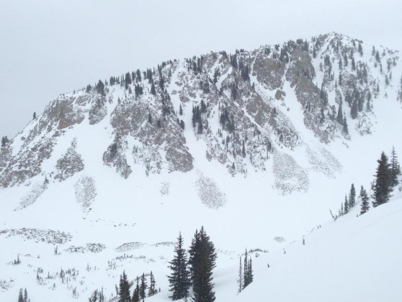
Moderate to strong winds from westerly directions have loaded many mid and upper elevation slopes. Such strong and persistent winds often load all aspects as they are channeled around terrain features. The photo below [Zimmerman-Wall] illustrates wind-scouring and cross-loading in Wolverine Cirque in the Salt Lake mountains. There is a HIGH avalanche danger today on wind loaded slopes, particularly at the mid and upper elevations.
|
| type | aspect/elevation | characteristics |
|---|

|
|
LIKELIHOOD
LIKELY
UNLIKELY
SIZE
LARGE
SMALL
TREND
INCREASING DANGER
SAME
DECREASING DANGER
|
|
description
With continued snowfall expected today, storm slabs will develop and may become quite sensitive, especially during any period of heavy precipitation. Additionally, loose snow sluffs may run fast and far, entraining large amounts of snow. There are a variety of more deeply buried weak layers in the snowpack, including rain crusts and facets. At mid to low elevations, the crusts are on all aspects. With the continued loading of snow, slides could start breaking into these deeper weak layers. |
| type | aspect/elevation | characteristics |
|---|

|
|
LIKELIHOOD
LIKELY
UNLIKELY
SIZE
LARGE
SMALL
TREND
INCREASING DANGER
SAME
DECREASING DANGER
|
|
description
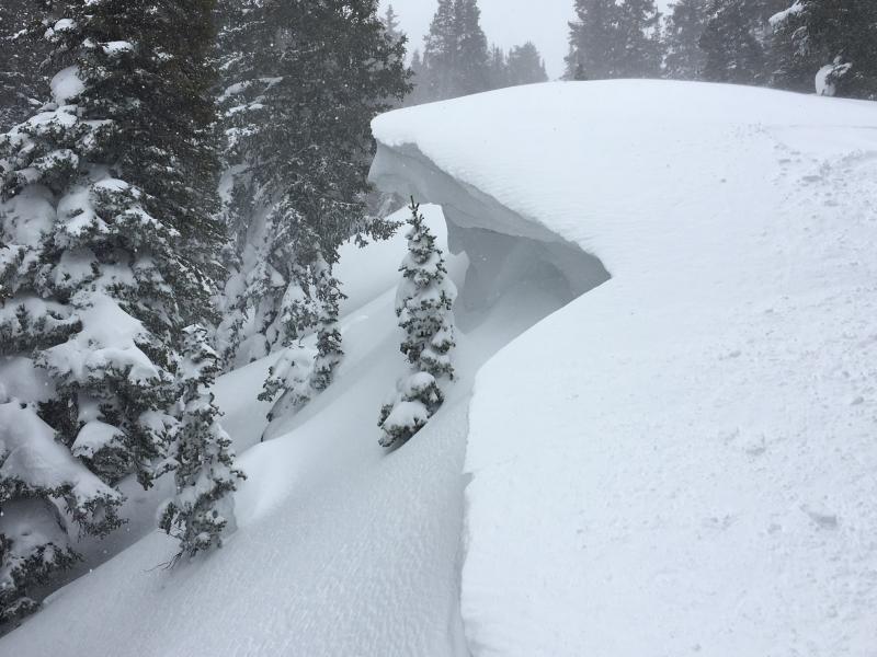
On Tuesday many observers noted the increasingly large and sensitive cornices that have developed, especially along upper elevation ridgelines. I heard more than one person comment "These are the largest cornices I have ever seen at this location!". These cornices are overhanging, and some have grown to 10'. They were quite sensitive on Tuesday, and were breaking back further than expected. Two observations noted class 1 slides that ran down into trees from large cornice drops. Stay well-away from the edge if traveling along a ridgeline.
|
 |
weather The National Weather Service has issued a Winter Storm Warning through this evening. Snowfall amounts of 7-12" are forecasted throughout the day, with continued moderate to strong winds at the mid and upper elevations. A cold front arrives about mid-day, which should shift the winds from the southwest to the west. Temperatures are currently in the 20's F and are expected to drop throughout the day. Continued snowfall overnight with diminishing winds. |
general announcements
|