25th Annual Black Diamond Fall Fundraising Party
Thursday, September 13; 6:00-10:00 PM; Black Diamond Parking Lot
25th Annual Black Diamond Fall Fundraising Party
Thursday, September 13; 6:00-10:00 PM; Black Diamond Parking Lot
| Advisory: Ogden Area Mountains | Issued by Evelyn Lees for Tuesday - January 10, 2017 - 5:27am |
|---|


|
bottom line More avalanches will occur today and the avalanche danger is rated HIGH at the upper elevations, and CONSIDERABLE at mid and low elevations. Natural avalanches are likely, and human triggered slides very likely. The avalanche danger will continue to INCREASE later today and tonight with additional heavy snow and continuing strong winds. Travel in avalanche terrain is not recommended.
|
 |
avalanche warning THE FOREST SERVICE UTAH AVALANCHE CENTER IN SALT LAKE CITY HAS CONTINUED THE BACKCOUNTRY AVALANCHE WARNING. * TIMING...THROUGH 6PM WEDNESDAY * AFFECTED AREA...THE MOUNTAINS OF NORTHERN UTAH, TO INCLUDE THE WASATCH RANGE, THE BEAR RIVER RANGE AND THE MOUNTAINS OF SOUTHEAST IDAHO, THE WESTERN UINTAS, AND THE MANTI-SKYLINE PLATEAU. * AVALANCHE DANGER...THE DANGER IS HIGH * REASON/IMPACTS...HEAVY SNOWFALL AND STRONG WINDS, COMBINED WITH RAIN ON SNOW AT THE LOWER ELEVATIONS WILL CREATE WIDESPREAD DANGEROUS AVALANCHE CONDITIONS. AVOID BEING ON OR BENEATH STEEP SLOPES. AVALANCHES RELEASING OFF STEEP ROOFS MAY BE DANGEROUS IN THE URBAN AND MOUNTAIN VALLEYS. THIS WARNING DOES NOT APPLY TO SKI AREAS WHERE AVALANCHE HAZARD REDUCTION MEASURES ARE PERFORMED. |
 |
special announcement Avalanche Education in the Ogden mountains Thursday January 12th – 6pm – Introduction to Avalanches Class (registration is required) Friday January 13th – 12:30pm – FREE Beacon Clinic – POW! day at Powder Mountain Friday January 13th – 5-8pm – Companion Rescue Fundamentals Class (registration is required) Friday January 13th – 6pm – FREE Know Before You Go Avalanche Awareness Presentation |
 |
current conditions A wall of cold air and moisture came marching into the valley around the dinner hour yesterday. This cold front dropped temperatures in a hurry and most trail heads this morning have seen a 10-15 degree F. drop in temperatures. Upper elevation temperatures are in the mid teens at most stations. Winds, mainly from the southwest, are beginning to increase once again ahead of another storm system. Only three Ogden area wind stations are working this morning - Mt Ogden is averaging 50 to 55, with gusts 60 to 79 mph, speeds at 9,000' are around 35 mph, gusts 45 to 50, and at 8,000' 15 mph, with gusts to 35 mph. Storm totals in the Ogden area mountains are in the 17 to 21" range, with about 3 inches of water weight. This new snow is dense and supportable, and even very low angle slopes have fast riding. |
 |
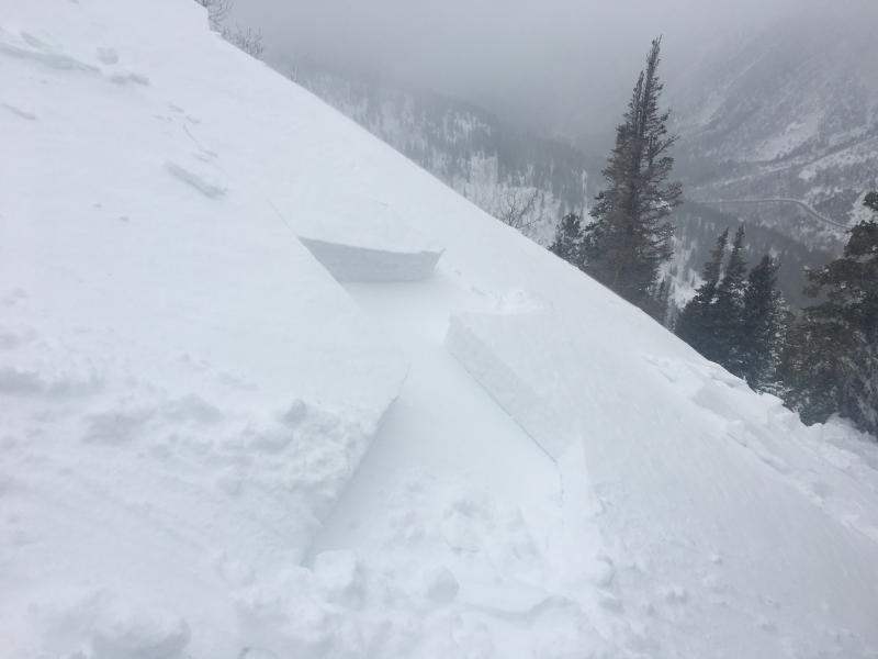
recent activity Yesterday, there was very poor visability and travel conditions in the Ogden area mountains, but there was a report of a natural avalanche cycle at the lower elevations, and we can assume there was also natural avalanche activity in the backcountry at the mid and upper elevations, too. Info from the SLC/PC mountains below: Many backcountry travelers reported very sensitive and touchy conditions, even at mid elevations. Most avalanches were failing within the new storm snow about a foot deep and up to a hundred feet wide - deep enough to bury a person. Avalanche workers reported widespread class 2 avalanches (class 2 is large enough to catch, carry and bury a person) released with ski cuts and explosives. Some avalanches started as new snow soft slabs, that had characteristics of a wet avalanche as they ran. There were reports of some slides propagating wider than usual and very sensitive. Some class 3 avalanches (class 3 is large enough to bury and destroy a car, truck or break trees) were released with explosives at upper elevations on a variety of aspects in backcountry-like terrain. One very experienced snow safety worker was caught and carried while working yesterday. He was caught in an avalanche that was roughly 2-5 ft deep and at this it is unknown how wide the avalanche was. He was carried and deployed an airbag.
|
| type | aspect/elevation | characteristics |
|---|

|
|
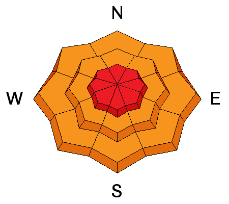
LIKELIHOOD
 LIKELY
UNLIKELY
SIZE
 LARGE
SMALL
TREND
 INCREASING DANGER
SAME
DECREASING DANGER
|
|
description
Natural and human triggered avalanches occurred again yesterday, and reported avalanches are steadily getting larger through out the range. With continued strong winds and more snow, expect more avalanches today, especially on slopes where the wind has drifted the snow. Cornices have been growing and may start falling and triggering slides as well. |
| type | aspect/elevation | characteristics |
|---|

|
|
LIKELIHOOD
 LIKELY
UNLIKELY
SIZE
LARGE
SMALL
TREND
INCREASING DANGER
SAME
DECREASING DANGER
|
|
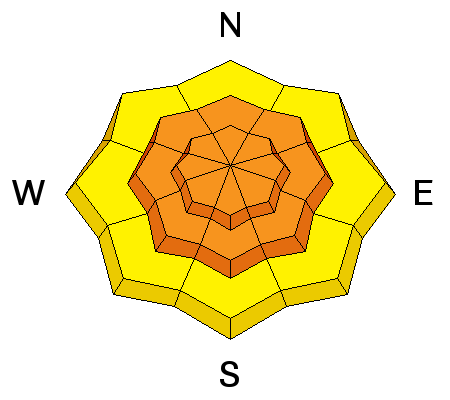
description
There are a variety of more deeply buried weak layers in the snowpack, including rain crusts and facets. At mid to low eleavations, the crusts are on all aspects. With the continued loading of snow, slides could start breaking into these deeper weak layers. Review the Ogden area avalanche observations to get a feel for the variety of buried weak layers. It's complex. |
| type | aspect/elevation | characteristics |
|---|

|

|
LIKELIHOOD
 LIKELY
UNLIKELY
SIZE
 LARGE
SMALL
TREND
 INCREASING DANGER
SAME
DECREASING DANGER
|
|
description
With more snow expected today and tonight, avalanches can be triggered in the new snow, even in wind sheltered terrain. The new snow will be especially sensitive during squalls and periods of heavy, intense snowfall. At the low elevations, the snow may not have completely cooled, and there could be weak wet snow beneath the new powder. |
 |
weather Warming temperatures and strong southwesterly winds are expected today ahead of the next storm system. The northern Wasatch mountains are expected to do well both today and tonight on the southwest flow - 6 to 12" of snow possible each 12 hour period. The rain/snow line will once again rise - perhaps to 6,500' later today and overnight. 8,000' temperatures will warm to near 30 today and tonight. The southwesterly winds will average 55 mph, with gusts to 80 possible for periods today and tonight. The cold front should pass through tomorrow afternoon, dropping temperatures once again. Finally a break later in the week, with a warming trend forecast Thursday through early next week. |
general announcements
|