25th Annual Black Diamond Fall Fundraising Party
Thursday, September 13; 6:00-10:00 PM; Black Diamond Parking Lot
25th Annual Black Diamond Fall Fundraising Party
Thursday, September 13; 6:00-10:00 PM; Black Diamond Parking Lot
| Advisory: Ogden Area Mountains | Issued by Paige Pagnucco for Saturday - January 7, 2017 - 5:24am |
|---|

|
bottom line The avalanche danger is MODERATE. Heightened avalanche conditions exist for wind slabs, loose dry snow and persistent slab avalanches. Human triggered avalanches are possible in steep terrain. Evaluate snow and terrain carefully. Re-evaluate your route when you encounter signs of instability like cracking, collapsing or recent avalanches. Special note: With forecast warming temperatures and rain in the next few days, pay very close attention to snow and ice falling from roofs. We received a ton of snow this week that is currently locked in place with the frigid air. Once the warm front moves into the area, a massive meltdown will occur. Do not stand, work, park your car or let your kids or pets play anywhere near where snow and ice could fall from above. These types of "avalanches" create deep piles quickly, can cause serious injury and, perhaps, even be fatal.
(pc: carscoops.com)
|
 |
special announcement Ogden Avalanche Education TODAY! Saturday January 7th – 1:30pm (NOTE TIME CHANGE) – FREE Know Before You Go Avalanche Awareness Presentation Thursday January 12th – 6pm – Introduction to Avalanches Class (registration is required) Friday January 13th – 12:30pm – FREE Beacon Clinic – POW! day at Powder Mountain Friday January 13th – 5-8pm – Companion Rescue Fundamentals Class (registration is required) Friday January 13th – 6pm – FREE Know Before You Go Avalanche Awareness Presentation _____________________________________________________________________ The Salt Lake City premier of The Fourth Phase from the creators of The Art of Flight will at Brewvies at 7 pm on Monday, Jan 9 |
 |
current conditions This morning's temperatures are warmer than yesterday's, but still quite brisk - Ben Lomond Peak is 19 F, Monte Cristo 15 F, and James Peak 11F. Winds picked up last night with Ogden Peak seeing generally southerly winds at 25-45 MPH with gusts up to 50 MPH. Riding conditions are still pretty good for skiers and snowmobilers alike. Safe, good riding conditions exist on sheltered slopes less than 30 degrees. The storm snow is soft and supportable though some areas are hard and windpacked - they will be obvious by their textured surface (see photo below). Conditions are going to start changing quickly as a warm, wet and windy system moves into the area during the day. Changing weather = changing avalanche conditions so pay attention to red flags like wind loading and cracking.
Wind art on the snow surface. (pc: D. DeBruin) |
 |
recent activity There were no reports of avalanche activity from the backcountry yesterday. Observers found good riding conditions where the wind had not wreaked havoc. One party near Rodeo Ridge reported two large collapses at very low elevations which could have been the result of brushy undergrowth and a shallower snowpack. |
| type | aspect/elevation | characteristics |
|---|

|
|
LIKELIHOOD
 LIKELY
UNLIKELY
SIZE
 LARGE
SMALL
TREND
 INCREASING DANGER
SAME
DECREASING DANGER
|
|
description
There is a ton of light powder snow available for transport so be mindful today of increased wind activity. Winds were fairly calm yesterday but picked up overnight and are now steady out of the south around 20 MPH with gusts much stronger on ridge tops. They will continue to transport snow today as the weather system moves in. Avoid steep slopes with fresh deposits of wind-drifted snow. Keep in mind that wind can transport snow up to 10X faster than actual snowfall so it doesn't have to be snowing for avalanche danger to increase. |
| type | aspect/elevation | characteristics |
|---|

|

|
LIKELIHOOD
LIKELY
UNLIKELY
SIZE
LARGE
SMALL
TREND
 INCREASING DANGER
SAME
DECREASING DANGER
|
|
description
The cold air has already had a profound weakening effect on the new snow. There are now weak crystals both on the surface and below. Observer's noted loose dry snow sluffs yesterday in steep terrain. These types of avalanches are usually manageable but, if you get knocked off your feet, you could end up taking a ride. Pay close attention to consequences like trees, gullies and cliffs when choosing your route and continue to practice safe travel protocols by only exposing one person at a time while everyone else watches from a safe spot. With the incoming warmer temperatures, loose snow on steep slopes may start to display more slab-like qualities. |
| type | aspect/elevation | characteristics |
|---|

|

|
LIKELIHOOD
 LIKELY
UNLIKELY
SIZE
LARGE
SMALL
TREND
INCREASING DANGER
SAME
DECREASING DANGER
|
|
description
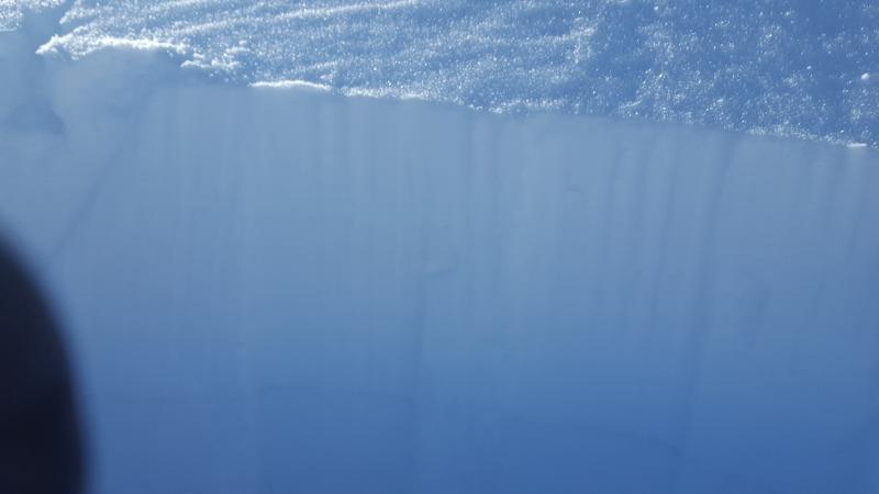
With the weight of new snow from this week's storms, deeper layers in the snowpack are stressed. An observer in the North Ogden Divide area found buried surface hoar about 1.5' feet down in the snowpack, similar to that found in the Monte Cristo area Thursday, while another party noted collapsing at low elevations. This is exactly the type of weak layer that, when overloaded by new snow or rain, can fail and cause a large avalanche. Observations suggest that it is more reactive the shallower the snowpack. This problem exists in many areas so the best way to identify the hazard is to dig pits and look for the buried weaknesses. It might take the weight of the upcoming warm and wet storm to really activate this layer, but it's still worth keeping in the back of your mind as you travel today.
Buried surface hoar, again, near the North Ogden Divide. (pc: Davis) |
 |
weather The National Weather Service in Salt Lake City has issued a Winter Storm Warning for the Ogden area mountains effective 8 pm tonight through 10 pm Monday. Today will be a transition day with mountain temperatures forecast around 20 F. Southerly winds will continue to blow 10-20 MPH with gusts near 30 MPH. It is not expected to snow much today with maybe an inch or two accumulating. The big changes start tonight with a warm up and increase in snowfall intensity. Snow levels are expected to rise to 7000-8000 feet tomorrow before getting cold again. We could see 1-2 feet of heavy snow by Monday night. . |
general announcements
|