25th Annual Black Diamond Fall Fundraising Party
Thursday, September 13; 6:00-10:00 PM; Black Diamond Parking Lot
25th Annual Black Diamond Fall Fundraising Party
Thursday, September 13; 6:00-10:00 PM; Black Diamond Parking Lot
| Advisory: Ogden Area Mountains | Issued by Mark Staples for Thursday - January 5, 2017 - 7:02am |
|---|

|
bottom line Today with an Avalanche Warning in effect, the avalanche danger is HIGH at upper elevations and CONSIDERABLE at mid elevations due to wind slabs, storm slabs and persistent slab avalanche problems. So much new snow from this storm and one early this week has created dangerous avalanche conditions.
|
 |
avalanche warning THE FOREST SERVICE UTAH AVALANCHE CENTER IN SALT LAKE CITY HAS CONTINUED A BACKCOUNTRY AVALANCHE WARNING. * TIMING...IN EFFECT FROM 6 AM MST THIS MORNING TO 6 AM MST FRIDAY * AFFECTED AREA...FOR THE MOUNTAINS OF NORTHERN UTAH INCLUDING THE WASATCH RANGE...BEAR RIVER RANGE AND THE WESTERN UINTA MOUNTAINS. * AVALANCHE DANGER...THE AVALANCHE DANGER FOR THE WARNING AREA IS HIGH. * REASON/IMPACTS...HEAVY SNOW HAS CREATED WIDESPREAD AREAS OF UNSTABLE SNOW. BOTH HUMAN TRIGGERED AND NATURAL AVALANCHES ARE LIKELY OR OCCURRING. STAY OFF OF AND OUT FROM UNDER SLOPES STEEPER THAN 30 DEGREES. THIS WARNING DOES NOT APPLY TO SKI AREAS WHERE AVALANCHE HAZARD REDUCTION MEASURES ARE PERFORMED. |
 |
special announcement The Salt Lake City premier of The Fourth Phase from the creators of The Art of Flight will at Brewvies at 7 pm on Monday, Jan 9 as a fundraiser for the Utah Avalanche Center. For tickets and details, go to https://utahavalanchecenter.org/event/fourth-phase |
 |
current conditions Temperatures have dropped into the single digits and low teens F this morning as the storm is ending and skies are clearing. Wind speeds appear to have decreased as they have shifted to the NW and are blowing about 10 mph with gusts of 15 mph. This storm started late Tuesday night and is ending this morning. It started warm with lots of graupel and finished cold with some light snow; therefore, its hard to say exactly how much snow fell. What we know for sure is how much water this snow contained, thus how much weight was added to the snowpack which is a more important number in terms of avalanche danger. More water weight = more stress = more avalanches. Snow water equivalent numbers for this storm (36 hour total) range from 1.8 inches water near Farmington and Lookout Peak to 2.5 inches of water near Powder Mountain to 3.2 inches of water at Ben Lomond Peak. Snow totals are roughly 10-20 inches. Video of Craig Gordon explaining why the storm increased the avalanche danger. |
 |
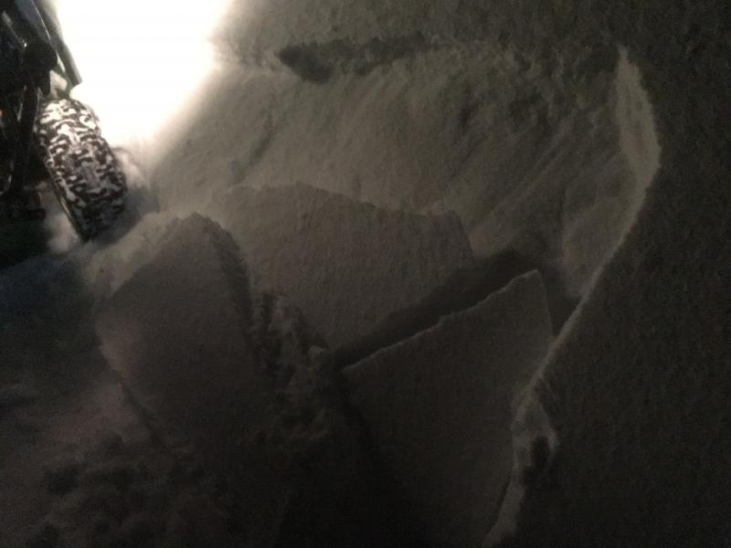
recent activity The only reported avalanche yesterday was a wind slab in someone's driveway last night in the Ogden valley. We don't have other reports of avalanche activity in the backcountry, but I'm certain there was some from the strong westerly winds and heavy snowfall. The peak instability likely occurred sometime late yesterday or last night. We may see evidence of these slides today. When small slides are happening in driveways, it's usually a good clue that avalanches are happening i the mountains.
Photo - D. Wewer |
| type | aspect/elevation | characteristics |
|---|

|
|
LIKELIHOOD
 LIKELY
UNLIKELY
SIZE
 LARGE
SMALL
TREND
 INCREASING DANGER
SAME
DECREASING DANGER
|
|
description
Strong westerly winds blew yesterday during the storm. An observer on Cutler Ridge of Ben Lomond Peak observed winds transporting snow yesterday at both mid and high elevations. Even though I think the peak instability occurred last night, I'm being conservative today with the danger rating simply based on the amount of new snow from this storm coupled with the storm from Monday/Tuesday. |
| type | aspect/elevation | characteristics |
|---|

|

|
LIKELIHOOD
LIKELY
UNLIKELY
SIZE
 LARGE
SMALL
TREND
INCREASING DANGER
SAME
DECREASING DANGER
|
|
description
Monday/Tuesday's storm was cold and produced light snow which is now capped by dense snow from this storm. Another observer on Ben Lomond Peak yesterday got very easy fractures within the new snow about a foot deep with just one light tap from his wrist. Dense, cohesive snow on top of light snow is always a good recipe for avalanches. This type of instability can heal in 24 hours. Unfortunately the weight of this new snow may keep deeper layers unstable for a longer period (see the next avalanche problem below). |
| type | aspect/elevation | characteristics |
|---|

|
|
LIKELIHOOD
 LIKELY
UNLIKELY
SIZE
LARGE
SMALL
TREND
 INCREASING DANGER
SAME
DECREASING DANGER
|
|
description
With the weight of new snow from both early this week and yesterday, deeper layers in the snowpack will be stressed and can cause larger avalanches. Last Thursday on Ben Lomond Peak, Drew and I consistently found a layer of facets on all aspects below 7500 feet above a thick ice crust that formed during rain in mid-December. We also found weak, faceted snow crystals on the snow surface but this layer was likely destroyed by strong winds before getting buried. I'm unsure how reactive these layers will be today, but don't trust them with so much weight on top. |
 |
weather With cold air descending from the north, today shouldn't warm at all and temperatures may even continue to drop a few more degrees. The good news is that winds should steadily decrease through the day and the sun may break through cloudy skies by afternoon. |
general announcements
|