25th Annual Black Diamond Fall Fundraising Party
Thursday, September 13; 6:00-10:00 PM; Black Diamond Parking Lot
25th Annual Black Diamond Fall Fundraising Party
Thursday, September 13; 6:00-10:00 PM; Black Diamond Parking Lot
| Advisory: Ogden Area Mountains | Issued by Evelyn Lees for Tuesday - January 3, 2017 - 7:21am |
|---|

|
bottom line The avalanche danger is MODERATE today on steep, wind drifted slopes at the mid and upper elevations. MODERATE means human triggered slides are possible. If winds speeds increase where you are, the avalanche danger will also increase on the wind-drifted slopes. Out of the wind-affected terrain, the avalanche danger will remain LOW to MODERATE. The most likely place to trigger a shallow new snow slab or sluff would be on a steep, northwest through easterly facing slope. If you head through a gate or out-of-bounds from a ski resort, you are in the backcountry and in avalanche terrain. You need to be prepared with a beacon, shovel and probe, and the avalanche education to use them and to evaluate the snowpack and terrain. There are LOTS of avalanche classes in the Ogden area mountains this month.
|
 |
special announcement Ogden Avalanche Education Saturday January 7th – 3pm – FREE Know Before You Go Avalanche Awareness Presentation Thursday January 12th – 6pm – Introduction to Avalanches Class (registration is required) Friday January 13th – 12:30pm – FREE Beacon Clinic – POW! day at Powder Mountain Friday January 13th – 5-8pm – Companion Rescue Fundamentals Class (registration is required) Friday January 13th – 6pm – FREE Know Before You Go Avalanche Awareness Presentation |
 |
current conditions The Ogden area mountains received no snow overnight, ended up with a nice 6 to 12” storm total. Skies are partly cloudy to overcast this morning, temperatures are in the single digits to mid teens, and the southwesterly winds are averaging 10 to 15 mph. Mount Ogden is averaging 30 mph, with gusts close to 40. |
 |
recent activity Easily triggered small soft slabs and sluffs were reported from the Ogden area mountains yesterday - new snow only. Bill Hunt photo - a sluff that ran 100 yards in steep terrain, 8600', N facing.
|
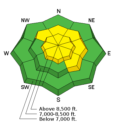
| type | aspect/elevation | characteristics |
|---|

|
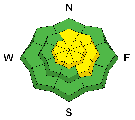
|
LIKELIHOOD
 LIKELY
UNLIKELY
SIZE
 LARGE
SMALL
TREND
 INCREASING DANGER
SAME
DECREASING DANGER
|
|
description
The new wind slabs will still be sensitive today, most widespread in upper elevation terrain. If the wind speeds increase where you are, sensitive drifts will rapidly develop and human triggered slides will be likely on steep slopes. Use small test slopes to gauge the sensitivity of the wind drifts. |
| type | aspect/elevation | characteristics |
|---|

|
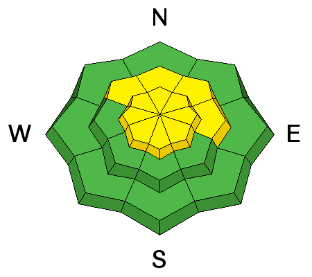
|
LIKELIHOOD
LIKELY
UNLIKELY
SIZE
 LARGE
SMALL
TREND
 INCREASING DANGER
SAME
DECREASING DANGER
|
|
description
Even out of the wind-affected terrain, the new snow will bond poorly to some of the old snow surfaces, though well to others. Be prepared to trigger new snow sluffs and shallow soft slabs on steep slopes , especially on sheltered, shady slopes. |
| type | aspect/elevation | characteristics |
|---|

|
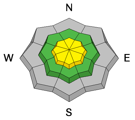
|
LIKELIHOOD
 LIKELY
UNLIKELY
SIZE
LARGE
SMALL
TREND
INCREASING DANGER
SAME
DECREASING DANGER
|
|
description
Any of the buried faceted weak layers should still be dormant, but a smaller new snow slide might be able to trigger a deeper slide in the snowpack, especially in a shallower snowpack area. These weak layers can be found around the compass, including some southerly facing slopes with facet-crust sandwiches., and mostly at the upper elevations. They also exist at the mid elevations in the Ogden area mountains around the buried rain crusts. |
 |
weather Skies will be mostly cloudy today, with a few snow flurries possible this morning. Temperatures will warm into the low 20s at 8,000’, and mid-teens along the high ridge lines. The southwesterly winds will be light at the mid elevations, averaging 10 to 15 mph. Across the higher terrain, wind speeds could increase to 25 to 35 mph with gusts in the 40s and 50s. The next storm will arrive by tomorrow morning, lasting into Thursday morning, with increasing temperatures, wind and heavy dense snow. |
general announcements
|


.jpg)