25th Annual Black Diamond Fall Fundraising Party
Thursday, September 13; 6:00-10:00 PM; Black Diamond Parking Lot
25th Annual Black Diamond Fall Fundraising Party
Thursday, September 13; 6:00-10:00 PM; Black Diamond Parking Lot
| Advisory: Ogden Area Mountains | Issued by Paige Pagnucco for Saturday - December 31, 2016 - 5:04am |
|---|


|
bottom line The avalanche danger is MODERATE on upper elevation slopes for wind slabs. Heightened avalanche conditions exist so evaluate the snow and terrain carefully.
|
 |
special announcement Ogden Avalanche Education Saturday January 7th – 3pm – FREE Know Before You Go Avalanche Awareness Presentation Thursday January 12th – 6pm – Introduction to Avalanches Class (registration is required) Friday January 13th – 12:30pm – FREE Beacon Clinic – POW! day at Powder Mountain Friday January 13th – 5-8pm – Companion Rescue Fundamentals Class (registration is required) Friday January 13th – 6pm – FREE Know Before You Go Avalanche Awareness Presentation |
 |
current conditions Happy New Year's Eve! Temperatures are a bit cooler on this last morning of 2016 with 17 F at the 8960' Monte Cristo weather station, 20 F at Ben Lomond (8000') and 14 F at James Peak (9425'). Winds shifted to the northwest overnight and are blowing 10-15 mph with ridge top gusts around 20+ mph. . Not much has changed since yesterday. The snow surface is continuing to weaken which, for now, makes for fun riding conditions, especially on lower angle terrain, but, in the long term, creates our next potential weak layer. You might still find soft conditions in sheltered mid and low elevation terrain where either surface hoar and/or recrystallized snow has developed. |
 |
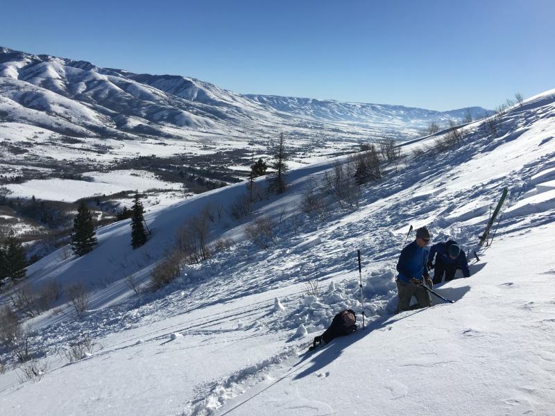
recent activity On Tuesday, skiers on Ben Lomond Peak triggered multiple fresh wind slabs 1-2 feet deep including a few that were remotely triggered or released sympathetically when they triggered another slide. Natural winds slabs were observed as well. Photo below shows UAC staff investigating a wind slab avalanche near Cutler Ridge.
Another slide was intentionally triggered by a skier in the southern end of Cache Valley near Paradise at 7900 feet. It broke 1 foot deep and 300 feet wide on facets near an ice crust on a non-wind loaded northeast facing slope.
|
| type | aspect/elevation | characteristics |
|---|

|
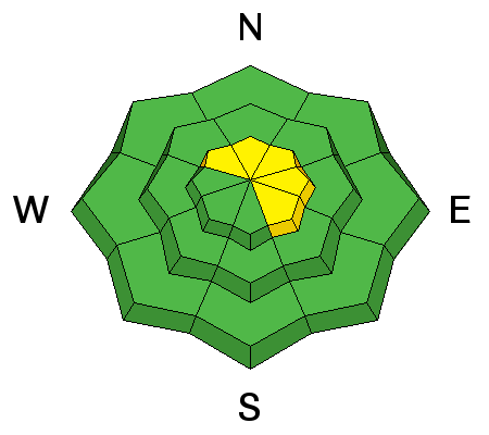
|
LIKELIHOOD
 LIKELY
UNLIKELY
SIZE
 LARGE
SMALL
TREND
 INCREASING DANGER
SAME
DECREASING DANGER
|
|
description
Wind slabs are getting harder and harder to trigger. Forecast calmer winds today should keep new formation in check. There are still soft and hard wind slabs in isolated areas so keep your avalanche eyes turned on. Avoid wind drifted, steep slopes, especially those with high consequences like cliffs, gullies and trees. |
| type | aspect/elevation | characteristics |
|---|

|
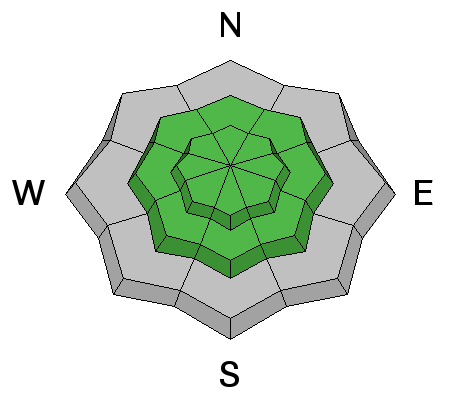
|
LIKELIHOOD
LIKELY
UNLIKELY
SIZE
LARGE
SMALL
TREND
INCREASING DANGER
SAME
DECREASING DANGER
|
|
description
There is still a sliver of a chance of triggering a persistent slab. Weak snow still exists within the snowpack, the most suspect of which is faceted snow just above the stout rain crust (or pencil density snow in some areas). This layer is obvious when you dig a pit and perform a shovel shear test but shows little enthusiasm for propagation. It's worth taking the time to dig in a variety of aspects and elevations to check how well this snow is bonding. Because this weak snow still gives me pause, I'd be leery of "going for it" today on the big, steep lines. |
| type | aspect/elevation | characteristics |
|---|

|
|
LIKELIHOOD
 LIKELY
UNLIKELY
SIZE
 LARGE
SMALL
TREND
 INCREASING DANGER
SAME
DECREASING DANGER
|
|
description
Finish off 2016 by testing out your avalanche rescue skills and equipment. Or better yet, your partner's. Take time to do a beacon drill - bury a pack a couple of feet deep with a beacon inside (remember to turn it on) and take turns going through the search process, including probing and shoveling. It doesn't take long and you'll feel better knowing you have the skills that could save someone's life. If you need a refresher, check out BCA's Companion Rescue Series. |
 |
weather Today will be a mix of sun and clouds with temperatures at 8500' nearing the mid to low 20's F. Westerly winds are forecasted to be light though probably a bit stronger on the high ridges. Change is on the way for the new year with a nice looking storm set to arrive Sunday. With it will come not only snow but very cold air. Time to restock the toe warmers. |
general announcements
|