25th Annual Black Diamond Fall Fundraising Party
Thursday, September 13; 6:00-10:00 PM; Black Diamond Parking Lot
25th Annual Black Diamond Fall Fundraising Party
Thursday, September 13; 6:00-10:00 PM; Black Diamond Parking Lot
| Advisory: Ogden Area Mountains | Issued by Paige Pagnucco for Friday - December 30, 2016 - 5:36am |
|---|

|
bottom line The avalanche danger is MODERATE on upper and mid-elevation slopes for wind slabs and persistent slabs. Heightened avalanche conditions exist so evaluate the snow and terrain carefully.
|
 |
special announcement The Forest Service National Avalanche Center just released this new video on avalanche problems. They serve as an extension of the avalanche danger scale and your understanding of them will allow you to better visualize the specific dangers you may face as well as make more informed decisions about your backcountry travel plans. |
 |
current conditions Temperatures at 5am are 31 F at the 8960' Monte Cristo weather station, 25 F at Ben Lomond (8000') and 25 F at James Peak (9425'). Winds are out of the southwest at 10-20 mph with gusts on the highest ridge tops up to 50 mph. . Expect a variety of snow conditions today. In spite of the strong winds earlier in the week, you might still find soft conditions in sheltered mid and low elevation terrain where surface hoar and/or recrystallized snow has developed making the riding fast and fun. |
 |
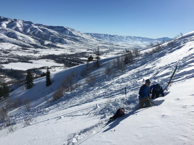
recent activity On Tuesday, skiers on Ben Lomond Peak triggered multiple fresh wind slabs 1-2 feet deep including a few that were remotely triggered or released sympathetically when they triggered another slide. Natural winds slabs were observed as well. Photo below shows UAC staff investigating a wind slab avalanche near Cutler Ridge.
Another slide was intentionally triggered by a skier in the southern end of Cache Valley near Paradise at 7900 feet. It broke 1 foot deep and 300 feet wide on facets near an ice crust on a non-wind loaded northeast facing slope.
|
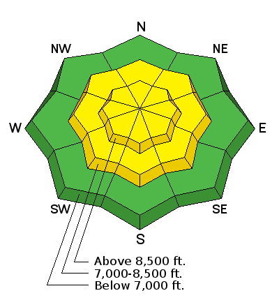
| type | aspect/elevation | characteristics |
|---|

|
|
LIKELIHOOD
 LIKELY
UNLIKELY
SIZE
 LARGE
SMALL
TREND
 INCREASING DANGER
SAME
DECREASING DANGER
|
|
description
Southwest winds continue to transport snow and create wind slabs along exposed ridge lines.Avoid areas of recently drifted snow at or near ridges or other prominent terrain features. Also, strong winds from earlier in the week formed hard wind slabs that are becoming more difficult to trigger. Avoid hollow sounding, pillowy looking drifts of wind blown snow on steep slopes. These wind slabs are failing on weak, faceted snow just above a solid crust buried about a foot deep. Though they are stubborn, once triggered, these hard slabs are difficult to get off of and could take you for a dangerous ride. Be mindful of consequences like cliffs, gullies and trees when choosing where to travel. |
| type | aspect/elevation | characteristics |
|---|

|
|
LIKELIHOOD
 LIKELY
UNLIKELY
SIZE
LARGE
SMALL
TREND
INCREASING DANGER
SAME
DECREASING DANGER
|
|
description
With additional wind loading, there is still a chance, albeit a small one, of triggering a persistent slab. Observers noted weak snow above (and below) the stout crust particularly at mid and low elevations. Of particular interest is the lack of propagation when the weak layers are tested. That does not mean it will not fail. A skier recently triggered a persistent slab that failed on facets above the crust near Paradise (south end of Cache Valley) at 7900 feet on a northeast facing slope. The best way to find this buried weak snow is to dig snow pits on a variety of aspects and elevations on small test slopes to see how well the snow near the crust is bonding before moving into steeper terrain. Slopes that have held snow since November or repeater slopes that have already avalanched but still harbor weak snow are also suspect. |
 |
weather It'll be another fairly mild day in the mountains with temperatures expected to reach near to just above freezing and light to moderate winds out of the southwest. Ridge top winds may be a bit gustier. Valley inversions will remain in place across northern Utah at least through Saturday. A stronger and colder system is forecasted to affect the zone for much of next week. |
general announcements
|