25th Annual Black Diamond Fall Fundraising Party
Thursday, September 13; 6:00-10:00 PM; Black Diamond Parking Lot
25th Annual Black Diamond Fall Fundraising Party
Thursday, September 13; 6:00-10:00 PM; Black Diamond Parking Lot
| Advisory: Ogden Area Mountains | Issued by Mark Staples for Wednesday - December 28, 2016 - 5:36am |
|---|

|
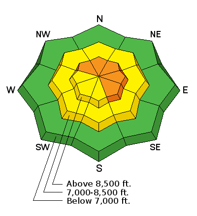
bottom line Today the avalanche danger is CONSIDERABLE on upper elevation, wind loaded slopes. Wind slabs are not the only concern. In places there is a weak, faceted layer of snow near an ice crust making avalanches possible and the danger MODERATE at mid elevations. At elevations below 7000 feet, the avalanche danger is LOW.
|
 |
current conditions Strong winds from yesterday continue this morning blowing westerly 15-20 mph gusting 40 mph with stronger winds in places like Ogden Peak. Under cloudy skies, temperatures are mostly in the low 20's F with a few snowflakes falling but not accumulating. |
 |
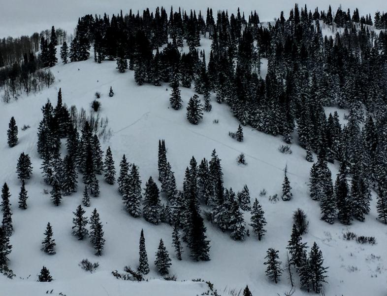
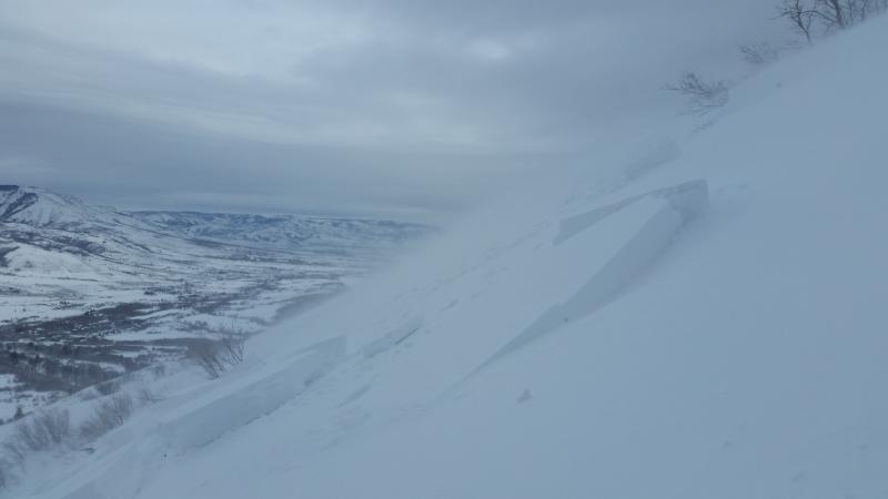
recent activity Explosives and ski cuts triggered wind slabs at ski areas yesterday up to 3 feet thick. Some were stubborn while some were very easy to trigger. Skiers on Ben Lomond Peak triggered many fresh wind slabs yesterday 1-2 feet deep including a few that were remotely triggered or released sympathetically when they triggered another slide (observation, avalanche1, avalanche2, avalanche3). These are major red flags. Remotely triggered avalanches are ones triggered from some distance without being on the slope that avalanches. Another slide was intentionally triggered by a skier in the southern end of Cache Valley near Paradise at 7900 feet. It broke 1 foot deep and 300 feet wide on facets near an ice crust on a non-wind loaded slope.
Photo below of a slide that a skier triggered on Ben Lomond Peak while descending lower angle terrain adjacent to the slide path (photo D. DeBruin & B. Bauter).
See the video (D. DeBruin & B. Bauter) showing these slides and winds yesterday on Ben Lomond Peak. |
| type | aspect/elevation | characteristics |
|---|

|
|
LIKELIHOOD
 LIKELY
UNLIKELY
SIZE
 LARGE
SMALL
TREND
 INCREASING DANGER
SAME
DECREASING DANGER
|
|
description
Strong winds have blown from the SW and W and may start shifting to the NW by the end of today. These winds transported snow yesterday and overnight forming many fresh wind slabs. Conditions today may be more tricky than yesterday because some wind slabs will be stubborn while others will remain easy to trigger. Wind slabs that were breaking on low density snow should start stabilizing today. Some were breaking near an ice crust buried about a foot deep. In places this ice crust may have small, faceted snow crystals either above or below it. These faceted crystals combined with continued strong winds will keep some wind slabs very sensitive today. |
| type | aspect/elevation | characteristics |
|---|

|
|
LIKELIHOOD
 LIKELY
UNLIKELY
SIZE
LARGE
SMALL
TREND
INCREASING DANGER
SAME
DECREASING DANGER
|
|
description
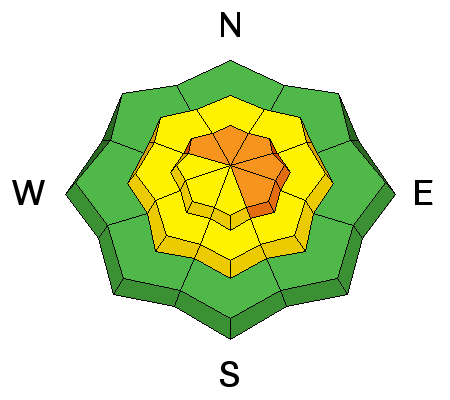
There is a rain/ice crust buried about a foot deep that has facets either above or below it. A skier near north Ogden Pass found this layering between 7000 and 8000 feet. A skier intentionally triggered a slide on this layering near Paradise, UT at 7900 feet. This slide was 300 feet wide. I am unsure of how widespread this layering is, but it should be easy to find. Dig only a foot or two deep and evaluate bonding of snow around this ice crust. Also, at upper elevations on NW, N, NE, and E aspects there remains a possibility of triggering a slide breaking at the ground on old snow from early November. |
 |
weather Today will have cloudy skies for the morning that should give way to sunshine by afternoon. A few snowflakes could fall this morning but not accumulation is expected. Temperatures will rise into the upper 20's F. Winds should slowly shift direction and blow from the NW by late afternoon at 10-15 mph. |
general announcements
|