25th Annual Black Diamond Fall Fundraising Party
Thursday, September 13; 6:00-10:00 PM; Black Diamond Parking Lot
25th Annual Black Diamond Fall Fundraising Party
Thursday, September 13; 6:00-10:00 PM; Black Diamond Parking Lot
| Advisory: Ogden Area Mountains | Issued by Evelyn Lees for Tuesday - December 27, 2016 - 7:11am |
|---|

|
bottom line As the winds increase today, the avalanche danger will rise to CONSIDERABLE on steep, upper elevation slopes with new drifts of wind blown snow. In upper elevation, wind drifted terrain there also continues to be an isolated chance of triggering a deeper slide, breaking to the ground. Out of the wind-affected terrain, the avalanche danger will remain LOW to MODERATE. Smaller wind drifts, dry sluffs and wet loose sluffs could be triggered on steep slopes.
|
 |
special announcement Once again this winter, our partners at the Wasatch Mountain Club are matching WMC member donations to the Utah Avalanche Center. If you are a WMC member and value avalanche forecasting and education, please send a check made out to the Utah Avalanche Center to the WMC at 1390 South 1100 East #103, Salt Lake City, UT 84105 |
 |
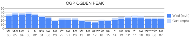
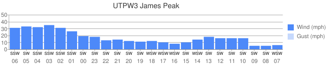
current conditions Skies are clear and temperatures in the Ogden area mountains are in the single digits and teens. Unfortunately, the southwesterly winds are increasing. Speeds across the highest peaks are averaging 30 to 35 mph, with gusts to 40. The mid elevation stations are reasonable – 15 to 25 mph averages. Wind graphs from the Ogden area mountains. Most recent is to the left
|
 |
recent activity Cracky, hollow wind slabs were found in the Ogden area backcountry yesterday. Avalanche work at the resorts triggered a few wind slabs and longer running sluffs in the loose snow. |
| type | aspect/elevation | characteristics |
|---|

|
|
LIKELIHOOD
 LIKELY
UNLIKELY
SIZE
 LARGE
SMALL
TREND
 INCREASING DANGER
SAME
DECREASING DANGER
|
|
description
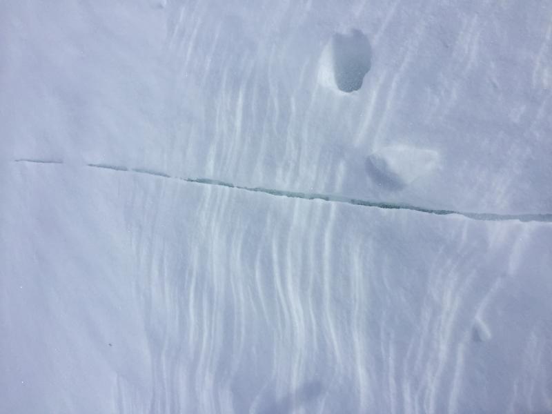
The southwesterly winds are increasing at the high elevations and expected to average 30 to 40 mph, with gusts to 60, by noon. There is abundant powder snow available for transport, so sensitive wind drifts will build and become easy to trigger. A laminar flow may keep most of the damaging wind transport to upper elevations, with mid elevation terrain remaining more wind-sheltered. Wind can change the landscape and increase the avalanche danger faster than any other weather factor, so be alert to the changing conditions and reevaluate often. Natural avalanches may become possible today, so be aware of what’s above you even when you are in wind-sheltered terrain. Plumes off the peaks, cracking of denser snow or your tracks filling in are signs of wind drifting Yesterday's small wind drifts will be deeper and more widespread today. Bill Brandt photo.
|
| type | aspect/elevation | characteristics |
|---|

|

|
LIKELIHOOD
 LIKELY
UNLIKELY
SIZE
 LARGE
SMALL
TREND
INCREASING DANGER
SAME
DECREASING DANGER
|
|
description
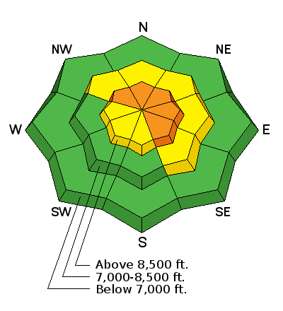
The combination of recent snow and additional loading from today’s wind, the facets near the ground on upper elevation slopes facing northwest through easterly remain suspect. In isolated places a person or a smaller new snow avalanche could trigger a slide to the ground. On most slopes, the mid and upper snow pack weaknesses are stabilizing. |
| type | aspect/elevation | characteristics |
|---|

|

|
LIKELIHOOD
LIKELY
UNLIKELY
SIZE
 LARGE
SMALL
TREND
 INCREASING DANGER
SAME
DECREASING DANGER
|
|
description
Out of the wind-affected terrain, smaller soft wind drifts, dry sluffs and maybe even a few wet loose sluffs could be triggered if warm temperatures and sun could dampen the snow on steep, sunny slopes. |
 |
weather An approaching weather system will graze northern Utah, bringing increasing clouds and wind through tonight, but very little snow. The southwesterly winds will ramp up by noon today along the higher ridgelines – 30 to 40 mph averages, with gusts to 60. Speeds at mid elevations could average 20 mph. 8000’ temperatures will warm to near 30. A few inches of snow are possible tonight, mostly north of I-80. High pressure will rebuild tomorrow, and the next chance for snow in northern Utah looks to be around Sunday. |
general announcements
|