25th Annual Black Diamond Fall Fundraising Party
Thursday, September 13; 6:00-10:00 PM; Black Diamond Parking Lot
25th Annual Black Diamond Fall Fundraising Party
Thursday, September 13; 6:00-10:00 PM; Black Diamond Parking Lot
| Advisory: Ogden Area Mountains | Issued by Evelyn Lees for Monday - December 26, 2016 - 7:12am |
|---|

|
bottom line There is a CONSIDERABLE avalanche danger today on steep upper elevation wind drifted slopes. The avalanche danger is MODERATE out of the wind effected terrain and on mid elevation slopes for triggering a new snow sluff, soft slab or smaller wind drift. There continues to be an isolated chance of triggering a deeper slide, breaking mid pack or to the ground. There is amazing turning and riding in untracked powder on slopes that are less steep than about 35 degrees and not connected to or below steep terrain, so give the snow on steep slopes another day to stabilize.
|
 |
special announcement Once again this winter, our partners at the Wasatch Mountain Club are matching WMC member donations to the Utah Avalanche Center. If you are a WMC member and value avalanche forecasting and education, please send a check made out to the Utah Avalanche Center to the WMC at 1390 South 1100 East #103, Salt Lake City, UT 84105 UDOT's draft backcountry closure policy can be found here and comments are welcome through January 6th. |
 |
current conditions The third major storm of December has once again filled in the old tracks with a blanket of incredible Utah powder. Storm totals:
This morning, skies are partly cloudy and temperatures icy cold – in the single digits to low teens. The southwesterly winds very light, averaging 10 - 15 mph, and even windy Mt Ogden is only averaging 25 mph. |
 |
recent activity No backcountry reports form the Ogden areas mountains, but info from the avalanche mitigation teams. The new snow was sensitive yesterday, with shallow soft slabs and lots of sluffs that were easily triggered on all aspects and elevations. In areas with the old rain crust, it acted as a slick bed surface, and the sluffs ran faster and further. |
| type | aspect/elevation | characteristics |
|---|

|
|
LIKELIHOOD
 LIKELY
UNLIKELY
SIZE
 LARGE
SMALL
TREND
 INCREASING DANGER
SAME
DECREASING DANGER
|
|
description
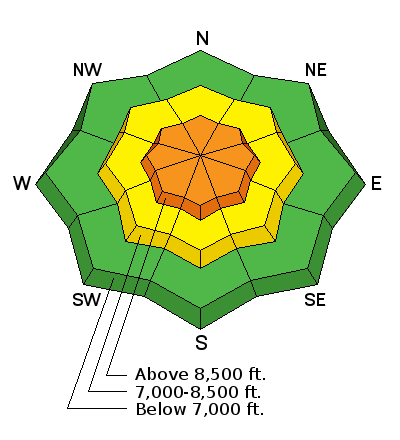
The upper elevations, wind affected terrain has the greatest hazard today – there are several layers of winds drifts, both soft and hard, that can be triggered by a person. Over the past 2 days, winds have blown from southeast through west through northwest, so drifts will be more widespread than usual and found on both mid an upper elevations slopes. Cornices tend to break back further than expected, so stay well back from the edges. Video of yesterday’s winds by Chad Brackelsberg from the Park City mountains. |
| type | aspect/elevation | characteristics |
|---|

|
|
LIKELIHOOD
 LIKELY
UNLIKELY
SIZE
LARGE
SMALL
TREND
 INCREASING DANGER
SAME
DECREASING DANGER
|
|
description
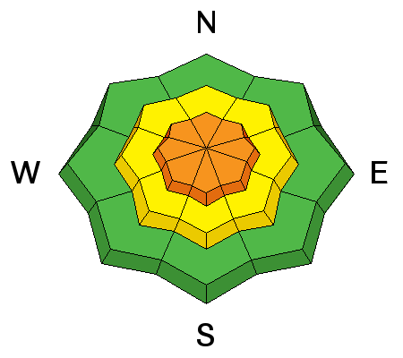
The new snow will be less sensitive today, but it will still be possible to trigger soft slabs and long running loose sluffs on steep slopes. Slope cuts on smaller features or test slopes will be useful. But triggering a soft slab in continuously steep terrain, above cliffs or where you get funneled into a gully could result in a long ride or burial. Because of the widespread rain crust beneath the snow snow, these sluffs can run further and faster than expected. |
| type | aspect/elevation | characteristics |
|---|

|
|
LIKELIHOOD
LIKELY
UNLIKELY
SIZE
 LARGE
SMALL
TREND
INCREASING DANGER
SAME
DECREASING DANGER
|
|
description
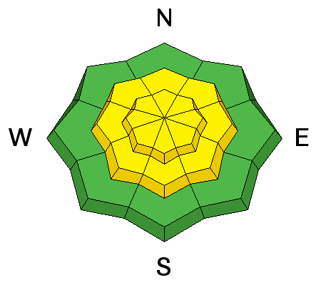
There are a few less predictable layers in the snow pack – two layers of small facets in the upper snow pack, including on wind sheltered mid elevation slopes, facet crust sandwiches and basal facets (limited to the very upper elevation northwest through northeasterly facing slopes). A slide triggered in the new snow could step down to one of these layers in isolated places or just run on the old snow/new snow interface, with long running, super sensitive gully-filling avalanches possible in areas where the surface hoar was preserved. These slides can be triggered from a distance. Doug Wewer photo of surface hoar/facets on the snow surface before the recent storm in the Ogden area mountains.
|
 |
weather High pressure is slowly building into the area and clouds will gradually decrease today. It will stay cold though, only warming to 10 degrees along the high ridge lines. The southwesterly winds will remain light, averaging about 10 mph in the terrain, and around 20 - 30 mph along the highest ridgelines. Cold and clear tonight, with light southwesterly winds. There’s a chance for a few inches of snow Tuesday night into Wednesday. |
| general announcements Remember your information can save lives. If you see anything we should know about, please help us out by submitting snow and avalanche conditions. You can also call us at 801-524-5304, email by clicking HERE, or include #utavy in your tweet or Instagram. To get help in an emergency (to request a rescue) in the Wasatch, call 911. Be prepared to give your GPS coordinates or the run name. Dispatchers have a copy of the Wasatch Backcountry Ski map. Backcountry Emergencies. It outlines your step-by-step method in the event of a winter backcountry incident. If you trigger an avalanche in the backcountry, but no one is hurt and you do not need assistance, please notify the nearest ski area dispatch to avoid a needless response by rescue teams. Thanks.
EMAIL ADVISORY If you would like to get the daily advisory by email you will need to subscribe here. DAWN PATROL Hotline updated daily by 5-530am - 888-999-4019 option 8. TWITTER Updates for your mobile phone - DETAILS UDOT canyon closures: LINK TO UDOT, or on Twitter, follow @UDOTavy, @CanyonAlerts or @AltaCentral Utah Avalanche Center mobile app - Get your advisory on your iPhone along with great navigation and rescue tools. Powderbird Helicopter Skiing - Blog/itinerary for the day Lost or Found something in the backcountry? - http://nolofo.com/ To those skinning uphill at resorts: it is critical to know the resort policy on uphill travel. You can see the uphill travel policy for each resort here. Benefit the Utah Avalanche Center when you shop from Backcountry.com or REI: Click this link for Backcountry.com or this link to REI, shop, and they will donate a percent of your purchase price to the UAC. Both offer free shipping (with some conditions) so this costs you nothing! Benefit the Utah Avalanche Center when you buy or sell on ebay - set the Utah Avalanche Center as a favorite non-profit in your ebay account here and click on ebay gives when you buy or sell. You can choose to have your seller fees donated to the UAC, which doesn't cost you a penny. This information does not apply to developed ski areas or highways where avalanche control is normally done. This advisory is from the U.S.D.A. Forest Service, which is solely responsible for its content. This advisory describes general avalanche conditions and local variations always exist. |