25th Annual Black Diamond Fall Fundraising Party
Thursday, September 13; 6:00-10:00 PM; Black Diamond Parking Lot
25th Annual Black Diamond Fall Fundraising Party
Thursday, September 13; 6:00-10:00 PM; Black Diamond Parking Lot
| Advisory: Ogden Area Mountains | Issued by Mark Staples for Wednesday - December 14, 2016 - 7:42am |
|---|

|
bottom line This morning the danger is MODERATE at mid and upper elevations and LOW at low elevations with wind slabs being the primary problem. A few inches of new snow and increased winds are expected today which will make this problem more prevalent. Additionally, avalanches can break deeper in the snowpack on buried layers of weak facets. These two avalanche problems combined with changing weather will make conditions tricky today.
|
 |
special announcement Discount lift tickets for Alta, Snowbird, Brighton, Solitude, Sundance, Snowbasin, Powder Mountain, and Beaver Mountain are now available, donated by the resorts to benefit the Utah Avalanche Center. Details and order information here. These make a great holiday gift and all proceeds go towards paying for avalanche forecasting and education!
Come join your local Avalanche Community to talk to friends and meet new ones at Gear:30 on Friday December 16th. |
 |
current conditions Snowfall started this morning with only a trace of snow in most places. Temperatures are in the mid teens to mid 20's F with winds blowing 10 mph from the W. Yesterday and last night, winds blew 20-30 mph from the SW. Great powder still exists on slopes sheltered from sun and wind. The last few days of clear weather (relatively warm sunny days and cold clear nights) has weakened the snow surface and formed a few small facets which may become buried today. There is also a thin crust on the snow surface in places. |
 |
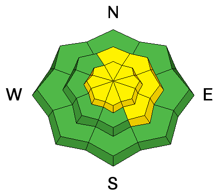
recent activity No new avalanche activity was reported in the Ogden Backcountry. Skiers near Salt Lake City in Big and Little Cottonwood Canyons triggered two wind slabs yesterday. These occurred on N and NE facing slopes. One of these slides didn't release until the second skier entered the slope. The other slide released when the party was making their third lap on the slope but entered about 50 feet higher. |
| type | aspect/elevation | characteristics |
|---|

|
|
LIKELIHOOD
 LIKELY
UNLIKELY
SIZE
 LARGE
SMALL
TREND
 INCREASING DANGER
SAME
DECREASING DANGER
|
|
description
Today's snowfall will provide more ammunition for winds which should increase today. Recent avalanches are bull's eye information. The combination of two wind slab avalanches yesterday and more snow and wind today, is a clear sign that we should expect more wind slabs and a rising danger. The good news about wind slabs is that they are easy to see and avoid. See the video illustration of wind slab formation below or click here. |
| type | aspect/elevation | characteristics |
|---|

|

|
LIKELIHOOD
LIKELY
UNLIKELY
SIZE
LARGE
SMALL
TREND
INCREASING DANGER
SAME
DECREASING DANGER
|
|
description
While wind slabs are easy to see and avoid, the persistent slab avalanche problem is much more tricky. This problem is caused by a slab of snow resting on a persistent weak layer of faceted snow crystals. We can't see if this problem exists or not without digging in the snow. This layer formed on the old surface snow prior to last weekend's wet and wild storm. This weak layer produced natural avalanches up to a couple feet deep. This problem has been more suspect in areas loaded by wind, but the snow structure exists on many aspects. Since last weekend's storm, the odds of triggering an avalanche on one of these faceted layers has decreased; HOWEVER, today's snow and wind will increase the odds slightly on wind loaded slopes. Additionally there is a faceted layer near the ground that produced several slides in the Ogden mountains on Saturday and Sunday. Unfortunately assessing the stability of facets near the ground is very difficult. The only strategy is look for this layer and avoid slopes that have it or choose slopes less than 30 degrees in steepness. |
 |
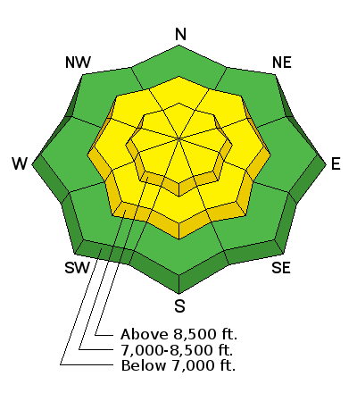
weather Today's snowfall should produce 3-6 inches of snow by tomorrow morning. Both winds and temperatures will be increasing today. By afternoon temperatures at 9000 feet should be near 30 degrees F and the rain/snow line will be near 7000 ft. Winds will be blowing 20 mph and gusting to 30 mph from the W and SW. Another storm with stronger winds and significantly more snow should arrive Thursday night. |
| general announcements Remember your information can save lives. If you see anything we should know about, please help us out by submitting snow and avalanche conditions. You can also call us at 801-524-5304, email by clicking HERE, or include #utavy in your tweet or Instagram. To get help in an emergency (to request a rescue) in the Wasatch, call 911. Be prepared to give your GPS coordinates or the run name. Dispatchers have a copy of the Wasatch Backcountry Ski map. Backcountry Emergencies. It outlines your step-by-step method in the event of a winter backcountry incident. If you trigger an avalanche in the backcountry, but no one is hurt and you do not need assistance, please notify the nearest ski area dispatch to avoid a needless response by rescue teams. Thanks.
EMAIL ADVISORY If you would like to get the daily advisory by email you will need to subscribe here. DAWN PATROL Hotline updated daily by 5-530am - 888-999-4019 option 8. TWITTER Updates for your mobile phone - DETAILS UDOT canyon closures: LINK TO UDOT, or on Twitter, follow @UDOTavy, @CanyonAlerts or @AltaCentral Utah Avalanche Center mobile app - Get your advisory on your iPhone along with great navigation and rescue tools. Powderbird Helicopter Skiing - Blog/itinerary for the day Lost or Found something in the backcountry? - http://nolofo.com/ To those skinning uphill at resorts: it is critical to know the resort policy on uphill travel. You can see the uphill travel policy for each resort here. Benefit the Utah Avalanche Center when you shop from Backcountry.com or REI: Click this link for Backcountry.com or this link to REI, shop, and they will donate a percent of your purchase price to the UAC. Both offer free shipping (with some conditions) so this costs you nothing! Benefit the Utah Avalanche Center when you buy or sell on ebay - set the Utah Avalanche Center as a favorite non-profit in your ebay account here and click on ebay gives when you buy or sell. You can choose to have your seller fees donated to the UAC, which doesn't cost you a penny.
|


 This information does not apply to developed ski areas or highways where avalanche control is normally done. This advisory is from the U.S.D.A. Forest Service, which is solely responsible for its content. This advisory describes general avalanche conditions and local variations always exist.