25th Annual Black Diamond Fall Fundraising Party
Thursday, September 13; 6:00-10:00 PM; Black Diamond Parking Lot
25th Annual Black Diamond Fall Fundraising Party
Thursday, September 13; 6:00-10:00 PM; Black Diamond Parking Lot
| Advisory: Ogden Area Mountains | Issued by Drew Hardesty for Monday - December 12, 2016 - 7:23am |
|---|

|
bottom line It's a complicated avalanche picture out there as not only the new storm takes its time to adjust but the pre-existing snow structure takes time to adjust. Areas of CONSIDERABLE danger still exists on steep mid and upper elevation wind drifted terrain. This will be most pronounced on mid and upper elevation easterly facing slopes, but certainly not limited to this terrain. Uncertainty, however, is high. A word to the wise: with great complexity and great uncertainty, great caution is required. Remember that terrain is your friend: excellent riding conditions can be found on sheltered slopes that are well less than 35 degrees in steepness.
|
 |
special announcement Fireside Chat - This Wednesday December 14th 7-8:30pm @ Black Diamond retail store: Matt McKee from UDOT and Evelyn Lees from the Utah Avalanche Center. Matt will review UDOT's new Avalanche Explosives Work Backcountry Closure Procedures for Provo, Little and Big Cottonwood Canyons and answer questions. Evelyn will discuss the current early winter snow pack and take a look at the concerns of buried crusts in the snowpack if there is time. Take this simple backcountry survey here. Help out my pal Jay Whitacre - he's getting his PhD on risk, decision-making and technology. Thanks - Snowbasin will be doing control work in Strawberry this morning - please avoid entering into this area until they have it open for the public. |
 |
current conditions Skies are partly to mostly cloudy this morning with temperatures warming through the night to the upper teens and low 20s. The westerly winds are blowing 20-25 along the high ridgelines. Snow surface conditions host some breakable wind and sun crust though protected terrain still hosts excellent soft powder. Maybe 3 stars. Quite the storm. Plenty of snow, westerly wind, rain to 7800' Saturday eve, rime, natural avalanches, close calls - it had it all. But first the numbers: Rough estimate of storm totals since Thursday night: Little Cottonwood: 20"/2.5" SWE Big Cottonwood: 20-30"/2.2-4.0" SWE PC ridgeline: 14-20"/1.6-2.0" SWE Ogden mountains: 36"/4.5" SWE Provo mountains: 16"/1.7" SWE |
 |
recent activity Many natural avalanches roared down overnight Saturday into early Sunday across the Wasatch range with reports coming in from Elk Point on Timpanogos, Box Elder peak, the upper Cottonwoods, the Park City ridgeline, north to the Ogden skyline and Ben Lomond. I understand that Toby and Paige in Logan reported a natural cycle in the mountains in their backyard as well. The complexity of these avalanches over the past couple days is not to be taken lightly:
Photos of the new, mid-pack, and deeper releases in order: (Falk, Hoffman, Logan J.)
|
| type | aspect/elevation | characteristics |
|---|

|
|
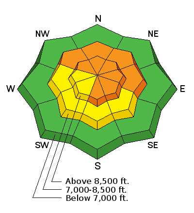
LIKELIHOOD
 LIKELY
UNLIKELY
SIZE
 LARGE
SMALL
TREND
 INCREASING DANGER
SAME
DECREASING DANGER
|
|
description
These persistent slabs are due to the weak snow grains formed in the old surface snow prior to the weekend's deluge and have produced natural avalanches up to a couple feet deep. They've been more suspect in areas loaded by wind, but the snow structure exists on many aspects. Propagation snow tests yesterday produced failures - albeit stubborn failures - along this plane. |
| type | aspect/elevation | characteristics |
|---|

|
|
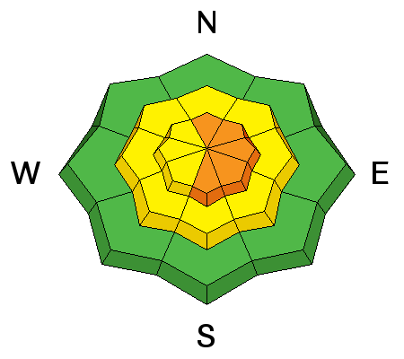
LIKELIHOOD
LIKELY
UNLIKELY
SIZE
 LARGE
SMALL
TREND
 INCREASING DANGER
SAME
DECREASING DANGER
|
|
description
On Saturday, two slides broke to the ground in the backcountry with a few more pulling out naturally in the Ogden mountains early Sunday morning - a warning that the depth hoar is active once again, overloaded by the new snow. Avalanche control work in upper LCC also produced slides to the ground yesterday in high northerly terrain. Slides can break directly on this layer, or a slide triggered in the new snow could step down to the facets as it moves down slope. The trouble here is that the warning signs are not obvious anymore - cracking and collapsing and natural activity won't be warning signs for this problem right now. Lots of snow analysis is required for entering the suspect terrain - or - best of all - avoid this habitat altogether or choose lower angle slopes. |
| type | aspect/elevation | characteristics |
|---|

|
|
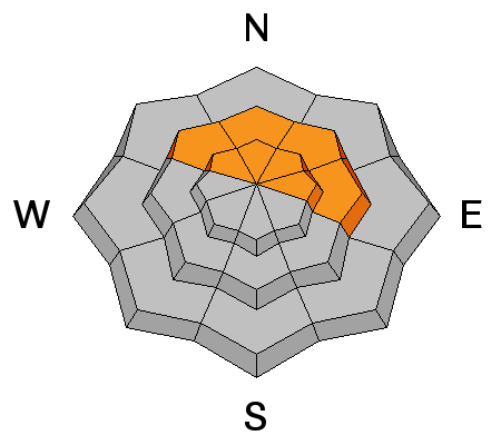
LIKELIHOOD
LIKELY
UNLIKELY
SIZE
LARGE
SMALL
TREND
 INCREASING DANGER
SAME
DECREASING DANGER
|
|
description
Lingering and developing wind drifts may be found on a variety of aspects and elevations. Test slopes and cornice drops should be reliable indicators. Watch for cross-loaded terrain features in steeper terrain. Even southerly aspects harbored natural wind slabs yesterday morning. |
 |
weather We'll have mostly becoming partly cloudy skies with breezy westerly winds expected to blow in the 20-25 mph range today. Temps will rise to the mid-20s. We can expect another round of precip with a warm front mid-week with a large trof developing for the weekend. |
| general announcements Remember your information can save lives. If you see anything we should know about, please help us out by submitting snow and avalanche conditions. You can also call us at 801-524-5304, email by clicking HERE, or include #utavy in your tweet or Instagram. To get help in an emergency (to request a rescue) in the Wasatch, call 911. Be prepared to give your GPS coordinates or the run name. Dispatchers have a copy of the Wasatch Backcountry Ski map. Backcountry Emergencies. It outlines your step-by-step method in the event of a winter backcountry incident. If you trigger an avalanche in the backcountry, but no one is hurt and you do not need assistance, please notify the nearest ski area dispatch to avoid a needless response by rescue teams. Thanks.
EMAIL ADVISORY If you would like to get the daily advisory by email you will need to subscribe here. DAWN PATROL Hotline updated daily by 5-530am - 888-999-4019 option 8. TWITTER Updates for your mobile phone - DETAILS UDOT canyon closures: LINK TO UDOT, or on Twitter, follow @UDOTavy, @CanyonAlerts or @AltaCentral Utah Avalanche Center mobile app - Get your advisory on your iPhone along with great navigation and rescue tools. Powderbird Helicopter Skiing - Blog/itinerary for the day Lost or Found something in the backcountry? - http://nolofo.com/ To those skinning uphill at resorts: it is critical to know the resort policy on uphill travel. You can see the uphill travel policy for each resort here. Benefit the Utah Avalanche Center when you shop from Backcountry.com or REI: Click this link for Backcountry.com or this link to REI, shop, and they will donate a percent of your purchase price to the UAC. Both offer free shipping (with some conditions) so this costs you nothing! Benefit the Utah Avalanche Center when you buy or sell on ebay - set the Utah Avalanche Center as a favorite non-profit in your ebay account here and click on ebay gives when you buy or sell. You can choose to have your seller fees donated to the UAC, which doesn't cost you a penny.
|


.JPG)


 This information does not apply to developed ski areas or highways where avalanche control is normally done. This advisory is from the U.S.D.A. Forest Service, which is solely responsible for its content. This advisory describes general avalanche conditions and local variations always exist.