25th Annual Black Diamond Fall Fundraising Party
Thursday, September 13; 6:00-10:00 PM; Black Diamond Parking Lot
25th Annual Black Diamond Fall Fundraising Party
Thursday, September 13; 6:00-10:00 PM; Black Diamond Parking Lot
| Advisory: Ogden Area Mountains | Issued by Evelyn Lees for Sunday - December 11, 2016 - 7:17am |
|---|


|
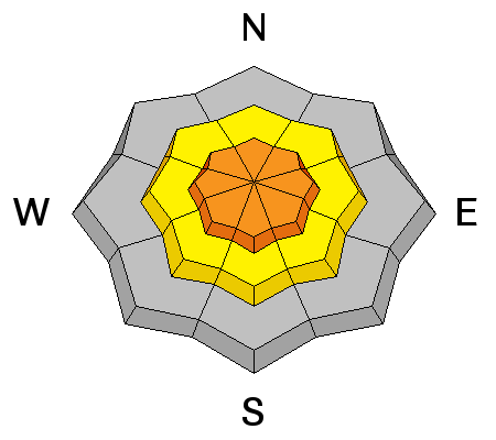
bottom line The Avalanche Danger is HIGH today on all steep upper elevation slopes and CONSIDERABLE on all steep mid elevation slopes. Natural avalanches are possible during periods of strong wind and human triggered slides certain. Travel in avalanche terrain is not recommended. Those with excellent avalanche and terrain evaluation skills who do head out should stay on lower angle terrain - slopes of about 30 degrees or less, without steep slopes above you. Long running natural avalanches occurred as recently as 4 am this morning.
|
 |
avalanche warning THE FOREST SERVICE UTAH AVALANCHE CENTER IN SALT LAKE CITY HAS EXTENDED THE BACKCOUNTRY AVALANCHE WARNING. * TIMING...IN EFFECT THROUGH 600 AM MONDAY. * AFFECTED AREA...THE NORTHERN WASATCH MOUNTAINS EAST OF OGDEN AND LOGAN...AND THE BEAR RIVER RANGE. * AVALANCHE DANGER...THE AVALANCHE DANGER REMAINS HIGH AT THE UPPER AND MID ELEVATIONS...AND WILL REMAIN ELEVATED THROUGH EARLY MONDAY MORNING. * REASON/IMPACTS...DENSE HEAVY SNOW COMBINED WITH STRONG WINDS HAVE CREATED WIDESPREAD AREAS OF UNSTABLE SNOW AT THE MID AND UPPER ELEVATIONS. BOTH HUMAN TRIGGERED AND NATURAL AVALANCHES ARE CERTAIN. STAY OFF OF AND OUT FROM UNDER SLOPES STEEPER THE 30 DEGREES. |
 |
current conditions After spending two days flirting along the Idaho border, the storm track finally dropped further south. The Ogden area mountains got pummeled again overnight, with the mountains south of I-80 picking up 5 to 10” of snow. 24-hour totals are now:
Light snow is still falling in the mountains, and temperatures have dropped into the upper teens to mid 20s. Winds have remained from a westerly direction, and are averaging 10 to 20 mph, with gusts to 30. Many of the wind sensors in the Ogden area mountains are probably rimed, and not reading properly. Guess is the highest peaks are ramping up for a few hours this morning, and could be gusting in the 50s and 60s. |
 |
recent activity Yesterday, in the Ogden area mountains explosives triggered Class 2 and class 3 slides in un-skied terrain and large collapses on upper elevation northeast facing slopes. Natural cornice falls were noted. Check the Logan area forecast for avalanche activity to the north, below is significant avalanche activity to the south.
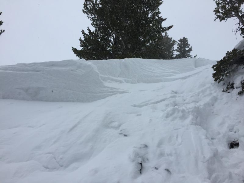
Days Fork hard slab avalanche
|
| type | aspect/elevation | characteristics |
|---|

|

|
LIKELIHOOD
 LIKELY
UNLIKELY
SIZE
 LARGE
SMALL
TREND
 INCREASING DANGER
SAME
DECREASING DANGER
|
|
description
The new snow did not bond well to the old snow, and both natural and human triggered new snow avalanches are likely today on steep mid and upper elevation slopes of all aspects. You may be able to trigger the new snow on just about any steep slope, but the snow will be especially sensitive in wind-drifted areas – yesterday people were able to trigger these new snow slides from a distance. If the winds pick up where you are or above you today, a natural avalanche cycle could occur. Avoid travel below avalanche paths and in avalanche run out zones. If you travel in the backcountry, use small test slopes to check the sensitivity and depth of the cracking drifts. At and below the rain/snow line, it will be possible to trigger small wet sluffs in the wet new snow and rain soaked old snow. Avoid travel in terrain traps, such as gullies, creek beds and below road banks, where even a small side can pile up debris. |
| type | aspect/elevation | characteristics | ||
|---|---|---|---|---|

|
|
LIKELIHOOD
 LIKELY
UNLIKELY
SIZE
LARGE
SMALL
TREND
INCREASING DANGER
SAME
DECREASING DANGER
|
||
|
description
Mid pack weak layers of buried facets, wind crusts and sun crusts could produce a few deeper slides today. Carefully read the recent Ogden area observations.
|
| type | aspect/elevation | characteristics |
|---|

|

|
LIKELIHOOD
 LIKELY
UNLIKELY
SIZE
LARGE
SMALL
TREND
INCREASING DANGER
SAME
DECREASING DANGER
|
|
description
Yesterday two human triggered slides broke to the ground in the backcountry to the south in the Cottonwoods and there was a natural to the ground in the Bear River range to the north - a warning that the depth hoar is active once again, overloaded by the new snow. Slides can break directly on this layer, or a slide triggered in the new snow could step down to the facets a it moves down slope. The facets seemed confined to upper elevation, shady slopes in the Ogden area mountains. |
 |
weather Today will be mostly cloudy, with light snow showers adding up to another inch or two. Temperatures will continue to cool, into the mid teens at the higher elevations in the Ogden area mountains. Winds will remain from a westerly direction, averaging 10 to 20 mph, with gusts to 30 mph. The highest peaks may occasionally gust to 50 mph, mostly before noon. Another stormy period is forecast to start on Tuesday. |
| general announcements Remember your information can save lives. If you see anything we should know about, please help us out by submitting snow and avalanche conditions. You can also call us at 801-524-5304, email by clicking HERE, or include #utavy in your tweet or Instagram. To get help in an emergency (to request a rescue) in the Wasatch, call 911. Be prepared to give your GPS coordinates or the run name. Dispatchers have a copy of the Wasatch Backcountry Ski map. Backcountry Emergencies. It outlines your step-by-step method in the event of a winter backcountry incident. If you trigger an avalanche in the backcountry, but no one is hurt and you do not need assistance, please notify the nearest ski area dispatch to avoid a needless response by rescue teams. Thanks.
EMAIL ADVISORY If you would like to get the daily advisory by email you will need to subscribe here. DAWN PATROL Hotline updated daily by 5-530am - 888-999-4019 option 8. TWITTER Updates for your mobile phone - DETAILS UDOT canyon closures: LINK TO UDOT, or on Twitter, follow @UDOTavy, @CanyonAlerts or @AltaCentral Utah Avalanche Center mobile app - Get your advisory on your iPhone along with great navigation and rescue tools. Powderbird Helicopter Skiing - Blog/itinerary for the day Lost or Found something in the backcountry? - http://nolofo.com/ To those skinning uphill at resorts: it is critical to know the resort policy on uphill travel. You can see the uphill travel policy for each resort here. Benefit the Utah Avalanche Center when you shop from Backcountry.com or REI: Click this link for Backcountry.com or this link to REI, shop, and they will donate a percent of your purchase price to the UAC. Both offer free shipping (with some conditions) so this costs you nothing! Benefit the Utah Avalanche Center when you buy or sell on ebay - set the Utah Avalanche Center as a favorite non-profit in your ebay account here and click on ebay gives when you buy or sell. You can choose to have your seller fees donated to the UAC, which doesn't cost you a penny.
|


 This information does not apply to developed ski areas or highways where avalanche control is normally done. This advisory is from the U.S.D.A. Forest Service, which is solely responsible for its content. This advisory describes general avalanche conditions and local variations always exist.