25th Annual Black Diamond Fall Fundraising Party
Thursday, September 13; 6:00-10:00 PM; Black Diamond Parking Lot
25th Annual Black Diamond Fall Fundraising Party
Thursday, September 13; 6:00-10:00 PM; Black Diamond Parking Lot
| Advisory: Ogden Area Mountains | Issued by Paige Pagnucco for Saturday - December 10, 2016 - 6:25am |
|---|


|
bottom line The avalanche danger is CONSIDERABLE this morning and dangerous avalanche conditions exist on steep mid and upper elevation slopes, especially on northwest through east facing slopes. Human triggered avalanches are likely so careful snowpack evaluation, cautious route-finding and conservative decision making are essential in the backcountry today. Avalanche danger will increase as continued snowfall and strong winds will combine to create widespread areas of unstable snow at mid and upper elevations today. Stay off of and out from under slopes steeper than 30 degrees. To stay safe today, your best bet is to find low angle, sheltered terrain.
|
 |
current conditions The National Weather Service has continued the Winter Storm Warning through tomorrow morning. The Ogden area mountains picked up another few inches of heavy snow since yesterday morning and it is currently still snowing. Ben Lomond Snotel shows .9" of SWE in the past 24 hrs while further south Parrish Creek shows only .2". Powder Mountain is reporting 5" of new snow in the past 24 hrs. Currently at 8000' temperatures are in the low 30's. West winds continue to blow averaging in the 20mph range overnight with gusts into the 40's at the highest elevations. Observer's report a variety of riding conditions in the Ogden backcountry, mostly based on elevation but found the best riding conditions in sheltered, low angle terrain.The higher up the drier the snow but the wind made exposed terrain a bit funky.The snow at lower elevations was reportedly "sopping wet."
|
 |
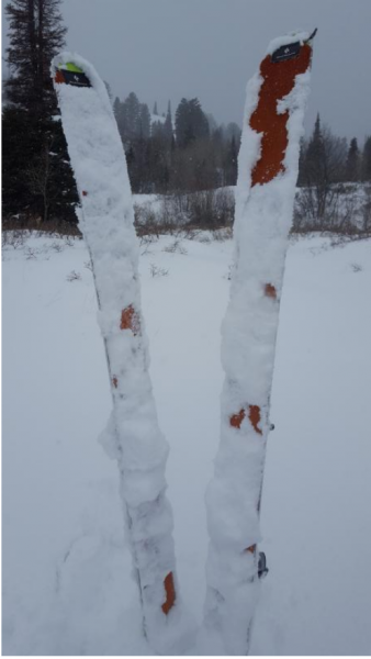
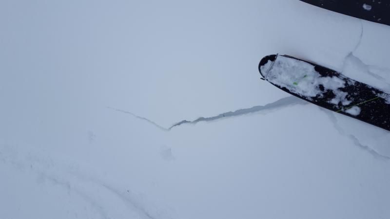
recent activity An Ogden observer noted a collapse while skinning under a short, steep rollover yesterday. Another observer found an active weak layer about 25cm down from the surface near a buried crust but also noted the difficulty in getting the layer to actually fail on nearby test slopes. They also noted cracking in wind affected areas.
Cracking. (pc: K. Davis) |
| type | aspect/elevation | characteristics |
|---|

|
|
LIKELIHOOD
 LIKELY
UNLIKELY
SIZE
 LARGE
SMALL
TREND
 INCREASING DANGER
SAME
DECREASING DANGER
|
|
description
Snow will continue to fall today and is forecasted to pick up intensity in the afternoon. The newly added water weight might be just enough to activate weaknesses in the snowpack. Best to avoid steep slopes today at the mid and high elevations as the snowpack adjusts. This is still early season so taking a ride in an avalanche will put you in danger of hitting rocks, stumps and downfall. If you are excited to get your sled out, sticking to the roads or grassy meadows may be your best option today. The snowpack is still too shallow to wander too far as rocks and stumps are lurking just beneath the surface. |
| type | aspect/elevation | characteristics |
|---|

|
|
LIKELIHOOD
LIKELY
UNLIKELY
SIZE
LARGE
SMALL
TREND
INCREASING DANGER
SAME
DECREASING DANGER
|
|
description
Westerly winds continue to be strong at the highest peaks and ridge lines. Avoid steep, wind-loaded slopes that have a smooth, rounded appearance or perhaps have a hollow sound. Watch for cross loaded slopes where wind might have deposited snow in gullies or along the lee of ridges. The strong winds have the potential to form widespread wind slabs in all open, exposed areas at mid and high elevations. |
 |
weather A moist westerly flow aloft will remain focused on the northern half of Utah throughout the weekend. Expect continued snowfall and windy ridge-top conditions in the Ogden area mountains today. The mountains could pick up another 3-6", certainly more in favored areas. Snowfall is forecasted to intensify this evening. Temps are expected to drop a bit in the late afternoon as colder air arrives ahead of the next impulse. The storm moves on by Sunday morning leaving lingering showers. High pressure aloft will produce a short break from active weather early next week. The next series of storms will arrive for the latter half of the week. |
| general announcements Remember your information can save lives. If you see anything we should know about, please help us out by submitting snow and avalanche conditions. You can also call us at 801-524-5304, email by clicking HERE, or include #utavy in your tweet or Instagram. To get help in an emergency (to request a rescue) in the Wasatch, call 911. Be prepared to give your GPS coordinates or the run name. Dispatchers have a copy of the Wasatch Backcountry Ski map. Backcountry Emergencies. It outlines your step-by-step method in the event of a winter backcountry incident. If you trigger an avalanche in the backcountry, but no one is hurt and you do not need assistance, please notify the nearest ski area dispatch to avoid a needless response by rescue teams. Thanks.
EMAIL ADVISORY If you would like to get the daily advisory by email you will need to subscribe here. DAWN PATROL Hotline updated daily by 5-530am - 888-999-4019 option 8. TWITTER Updates for your mobile phone - DETAILS Utah Avalanche Center mobile app - Get your advisory on your iPhone along with great navigation and rescue tools. Lost or Found something in the backcountry? - http://nolofo.com/ To those skinning uphill at resorts: it is critical to know the resort policy on uphill travel. You can see the uphill travel policy for each resort here. Benefit the Utah Avalanche Center when you shop from Backcountry.com or REI: Click this link for Backcountry.com or this link to REI, shop, and they will donate a percent of your purchase price to the UAC. Both offer free shipping (with some conditions) so this costs you nothing! Benefit the Utah Avalanche Center when you buy or sell on ebay - set the Utah Avalanche Center as a favorite non-profit in your ebay account here and click on ebay gives when you buy or sell. You can choose to have your seller fees donated to the UAC, which doesn't cost you a penny.
|


 This information does not apply to developed ski areas or highways where avalanche control is normally done. This advisory is from the U.S.D.A. Forest Service, which is solely responsible for its content. This advisory describes general avalanche conditions and local variations always exist.