25th Annual Black Diamond Fall Fundraising Party
Thursday, September 13; 6:00-10:00 PM; Black Diamond Parking Lot
25th Annual Black Diamond Fall Fundraising Party
Thursday, September 13; 6:00-10:00 PM; Black Diamond Parking Lot
| Advisory: Ogden Area Mountains | Issued by Evelyn Lees for Friday - November 25, 2016 - 7:10am |
|---|

|
bottom line Most terrain still has a LOW danger in the Ogden area mountains. A MODERATE danger exists in steep wind-drifted terrain primarily in the upper elevations along the highest ridge lines, though look for and avoid any smaller drifts that develop in open bowls at the mid elevations. Getting caught even in a small slide can result in injury from hitting rocks due to the very thin coverage.
|
 |
special announcement Generally speaking, if you're heading to a ski area please check in with the individual ski resort and find out their uphill traffic policies. More info and links to the resorts here. |
 |
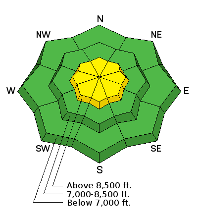
current conditions Under clear skies, there is a slight temperature inversion in the mountains - the low elevations in the Ogden area mountains have temperatures near 20, while the mid elevations are in the low 30s. The southwesterly winds are averaging 15 to 20 mph, with the high Ogden ridge lines and peaks averaging 25 to 35 mph, with gusts to 45 mph. The early season snow pack is still very shallow, and there really isn't enough snow to recreate yet in the Ogden area mountains unless you can get up very high. The sunny, southerly facing slopes are crusted. Approximate upper elevation snow depths through out the Wasatch:
|
 |
recent activity None |
| type | aspect/elevation | characteristics |
|---|

|

|
LIKELIHOOD
 LIKELY
UNLIKELY
SIZE
 LARGE
SMALL
TREND
 INCREASING DANGER
SAME
DECREASING DANGER
|
|
description
Today, new drifts of wind blown snow are the number one concern. There is snow available for transport, and the increasing southwesterly winds will drift snow both along the high ridge lines and down into mid slope open bowls. Plumes of snow blowing off the ridge lines and new cornices mean the wind is transporting snow. Shooting cracks in the snow indicate a sensitive wind slab, to be avoided on steep slopes. |
| type | aspect/elevation | characteristics |
|---|

|

|
LIKELIHOOD
 LIKELY
UNLIKELY
SIZE
 LARGE
SMALL
TREND
 INCREASING DANGER
SAME
DECREASING DANGER
|
|
description
The Ogden area mountains have a couple inches of weak faceted snow near the base of the snow pack, but this is limited to the highest, shady locations. It's possible that any new snow slide may step down into this older layering. |
 |
weather High pressure will bring sunny skies and warm temperatures to the mountains today. 8,000’ temperatures will reach the low 40s, and ridge line temperatures will warm into the low 30s. The southwesterly winds will slowly increase today - by afternoon, averages to 20 mph will be common along most ridge lines, with the highest peaks averaging40 mph, with gusts in the 50s by evening. Saturday, look for increasing clouds and southwesterly winds, with the next storm slated for Saturday night into Sunday morning. Utah stays in the fast moving storm track, with more snow next week. |
| general announcements Remember your information can save lives. If you see anything we should know about, please help us out by submitting snow and avalanche conditions. You can also call us at 801-524-5304, email by clicking HERE, or include #utavy in your tweet or Instagram. To get help in an emergency (to request a rescue) in the Wasatch, call 911. Be prepared to give your GPS coordinates or the run name. Dispatchers have a copy of the Wasatch Backcountry Ski map. Backcountry Emergencies. It outlines your step-by-step method in the event of a winter backcountry incident. If you trigger an avalanche in the backcountry, but no one is hurt and you do not need assistance, please notify the nearest ski area dispatch to avoid a needless response by rescue teams. Thanks.
EMAIL ADVISORY If you would like to get the daily advisory by email you will need to subscribe here. DAWN PATROL Hotline updated daily by 5-530am - 888-999-4019 option 8. TWITTER Updates for your mobile phone - DETAILS UDOT canyon closures: LINK TO UDOT, or on Twitter, follow @UDOTavy, @CanyonAlerts or @AltaCentral Utah Avalanche Center mobile app - Get your advisory on your iPhone along with great navigation and rescue tools. Powderbird Helicopter Skiing - Blog/itinerary for the day Lost or Found something in the backcountry? - http://nolofo.com/ To those skinning uphill at resorts: it is critical to know the resort policy on uphill travel. You can see the uphill travel policy for each resort here. Benefit the Utah Avalanche Center when you shop from Backcountry.com or REI: Click this link for Backcountry.com or this link to REI, shop, and they will donate a percent of your purchase price to the UAC. Both offer free shipping (with some conditions) so this costs you nothing! Benefit the Utah Avalanche Center when you buy or sell on ebay - set the Utah Avalanche Center as a favorite non-profit in your ebay account here and click on ebay gives when you buy or sell. You can choose to have your seller fees donated to the UAC, which doesn't cost you a penny.
|


 This information does not apply to developed ski areas or highways where avalanche control is normally done. This advisory is from the U.S.D.A. Forest Service, which is solely responsible for its content. This advisory describes general avalanche conditions and local variations always exist.