25th Annual Black Diamond Fall Fundraising Party
Thursday, September 13; 6:00-10:00 PM; Black Diamond Parking Lot
25th Annual Black Diamond Fall Fundraising Party
Thursday, September 13; 6:00-10:00 PM; Black Diamond Parking Lot
| Advisory: Moab Area Mountains | Issued by Eric Trenbeath for Sunday - April 8, 2018 - 7:06am |
|---|

|
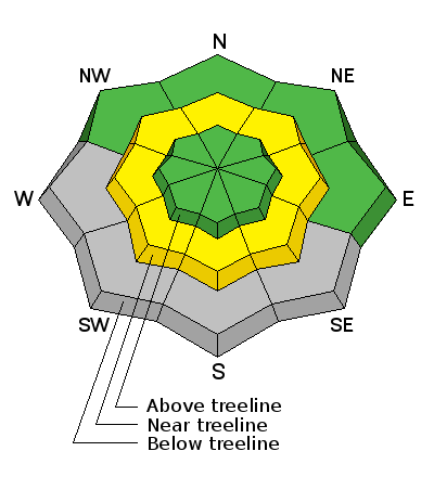
bottom line The avalanche danger is generally LOW this morning but could rise to MODERATE today as daytime heating increases the danger for loose, wet avalanches. Areas of concern can be found in steep, rocky terrain, right around treeline and below where the snowpack is unconsolidated and we haven't seen a solid refreeze. Stay off of steep slopes that feel punchy, or sloppy and wet.
|
 |
special announcement This will be our last regularly scheduled advisory. |
 |
current conditions Clouds are lingering over the mountains but skies are already clearing to the west as the "atmospheric river" storm event moves eastward. Ridge top NW winds are averaging 15-20 mph and 10,000' temps dipped below freezing at 6:00 a.m. Though the storm produced more than an inch of rain above 10,000' in the Wasatch and Uintah mountains, the event proved rather underwhelming for the La Sals and that's probably a good thing. We received no snow, and barely measureable precipitiaton, just enough to dampen the snow and form a thin ice crust with last night's minor freeze. Needless to say, turning and riding condtions won't be great. New snow totals in Gold Basin. Snow totals at the Geyser Pass Trailhead, (9600') Wind, temperature, and humidity on Pre Laurel Peak (11,700') |
 |
recent activity |
| type | aspect/elevation | characteristics |
|---|

|

|
LIKELIHOOD
 LIKELY
UNLIKELY
SIZE
 LARGE
SMALL
TREND
 INCREASING DANGER
SAME
DECREASING DANGER
|
|
description
We didn't receive enough moisture from this storm to saturate the snowpack and create dangerous avalanche conditions. Nevertheless, the snowpack has weathered above freeezing temperatures for a couple of days now and we did add a little water. With daytime heating, it may be possible to trigger loose, wet avalanches, particulalry in areas where the snow is unconsolidated. The most suspect terrain is steep and rocky, right around treeline. If the snow is punchy, wet, or sloppy, and if you se pinwheels, rollerballs, or loose snow sloughing, it's time to get off of steep terrain. |
 |
weather Forecast is for clouds and lingering showers this morning but skies area already clearing. NW winds will average 20-25 mph along ridge tops with gusts as high as 40. 10,000' temps will be in the high 30's.
|
| general announcements The UAC has new support programs with Outdoor Research and Darn Tough. Support the UAC through your daily shopping. When you shop at Smith's, or online at Outdoor Research, REI, Backcountry.com, Darn Tough, Patagonia, NRS, Stio, Amazon, and eBay a portion of your purchase will be donated to the FUAC. See our Donate Page for more details on how you can support the UAC when you shop. Benefit the Utah Avalanche Center when you buy or sell on eBay - set the Utah Avalanche Center as a favorite non-profit in your eBay account here and click on eBay gives when you buy or sell. You can choose to have your seller fees donated to the UAC, which doesn't cost you a penny. This information does not apply to developed ski areas or highways where avalanche control is normally done. This advisory is from the U.S.D.A. Forest Service, which is solely responsible for its content. This advisory describes general avalanche conditions and local variations always occur. |


