25th Annual Black Diamond Fall Fundraising Party
Thursday, September 13; 6:00-10:00 PM; Black Diamond Parking Lot
25th Annual Black Diamond Fall Fundraising Party
Thursday, September 13; 6:00-10:00 PM; Black Diamond Parking Lot
| Advisory: Moab Area Mountains | Issued by Eric Trenbeath for Thursday - March 29, 2018 - 6:57am |
|---|

|
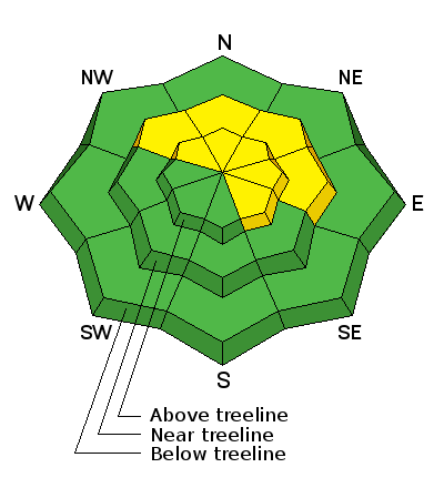
bottom line Areas of isolated or MODERATE danger still exist on steep, wind drifted slopes right around treeline and above that face NW-N-E where it may be possible to trigger a deep persistent slab avalanche up to 4' deep, particularly in areas of rocky or more radical terrain. Steep wooded areas are also suspect. Choose slopes wisely and avoid steep convexities and blind break-overs. Most other terrain in the La Sals currently offers LOW danger.
|
 |
special announcement Episode 7 of the UAC Podcast "Mastery and False Mastery - An Interview with 'Big' Don Sharaf" is live. With a snow career spanning over 30 years, Don has enough mileage in the mountains to have learned a thing or two, including the profound value of humility when staring into the face of the dragon. Listen in on our conversation about the idea of mastery and if such a thing can exist in the avalanche world. Check it out on the UAC blog, ITunes, Stitcher, or wherever you get your podcasts. The UAC Marketplace is still open. Our online marketplace still has deals on skis, packs, airbag packs, beacons, snowshoes, soft goods and much more. INSTAGRAM! We now have a UAC-Moab Instagram page. You can find it here....but better yet follow us on your smartphone. Confused? Ask a teenager. |
 |
current conditions Skies are clear, 10,000' temps are in the mid teens, and northwesterly winds are cranking in the 30-40 mph range. It's been a week since our last snowfall, and snow surfaces are typical mixed bag, spring conditions. New snow totals in Gold Basin. Snow totals at the Geyser Pass Trailhead, (9600') Wind, temperature, and humidity on Pre Laurel Peak (11,700') |
 |
recent activity |
| type | aspect/elevation | characteristics |
|---|

|
|
LIKELIHOOD
 LIKELY
UNLIKELY
SIZE
 LARGE
SMALL
TREND
 INCREASING DANGER
SAME
DECREASING DANGER
|
|
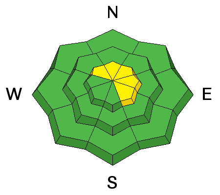
description
There isn't much snow available for transport, but there may be some isolated fresh wind drifts formed by the strong NW winds, or a few old hard wind slabs about. Suspect smooth rounded deposits of wind drifted snow, or areas that have a hollow sound or feel to them. Even a small wind slab triggered in areas of more extreme terrain could sweep you off your feet and take you for a ride over a cliff. |
| type | aspect/elevation | characteristics |
|---|

|
|
LIKELIHOOD
LIKELY
UNLIKELY
SIZE
 LARGE
SMALL
TREND
INCREASING DANGER
SAME
DECREASING DANGER
|
|
description
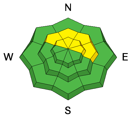
We've entered the low probability - high consesquence phase with our persistent slab problem. Weak snow still exists right around treeline and above on slopes that face NW-N-E and it may still be possible to trigger an avalanche up to 4' deep in these areas. Slopes with an easterly component are the most suspect, as are areas of rocky and more radical terrain. Choose slopes wisely and be leary of steep convexities and blind breakovers. |
 |
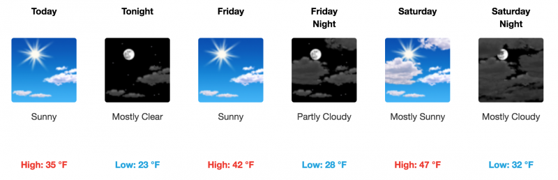
weather
|
| general announcements The UAC has new support programs with Outdoor Research and Darn Tough. Support the UAC through your daily shopping. When you shop at Smith's, or online at Outdoor Research, REI, Backcountry.com, Darn Tough, Patagonia, NRS, Stio, Amazon, and eBay a portion of your purchase will be donated to the FUAC. See our Donate Page for more details on how you can support the UAC when you shop. Benefit the Utah Avalanche Center when you buy or sell on eBay - set the Utah Avalanche Center as a favorite non-profit in your eBay account here and click on eBay gives when you buy or sell. You can choose to have your seller fees donated to the UAC, which doesn't cost you a penny. This information does not apply to developed ski areas or highways where avalanche control is normally done. This advisory is from the U.S.D.A. Forest Service, which is solely responsible for its content. This advisory describes general avalanche conditions and local variations always occur. |