25th Annual Black Diamond Fall Fundraising Party
Thursday, September 13; 6:00-10:00 PM; Black Diamond Parking Lot
25th Annual Black Diamond Fall Fundraising Party
Thursday, September 13; 6:00-10:00 PM; Black Diamond Parking Lot
| Advisory: Moab Area Mountains | Issued by Eric Trenbeath for Thursday - February 22, 2018 - 6:41am |
|---|

|
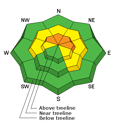
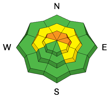
bottom line The avalanche danger is CONSIDERABLE today on steep slopes that face NW-N-E right around treeline and above, especially on slopes that have recent deposits of wind drifted snow. Human triggered wind slabs, and deeper persistent slab avalanches up to 3' deep are likely in these areas. The avalanche danger is MODERATE on steep, northerly aspects slopes at mid elevations. Low elevation, and south facing terrain offers mostly LOW danger.
|
 |
special announcement Episode 5 of the UAC podcast "To Hell in a Heartbeat - A Conversation With Tom Diegel and Matt Clevenger About the 12.26.08 Full Burial on Little Water" is live. Matt and Tom talk about the avalanche documented in To Hell in a Heartbeat. Check it out on ITunes, Stitcher, the UAC blog. The UAC Marketplace is still open. Our online marketplace still has deals on skis, packs, airbag packs, beacons, snowshoes, soft goods and much more. |
 |
current conditions Winter will continue in the La Sal Mountains today. 2" of snow has fallen overnight, SW winds are averaging 15-20 mph along ridge tops with gusts into the 30's, and it's a chilly 10 degrees at 10,000'. Soft settled power conditions exist below treeline while above winds have scoured surfaces and drifted snow on leeward slopes. The snowpack is still thin but we now have a skiable and rideable base with 40" on the ground at 10,000' in Gold Basin. Use caution and tread lightly as there are many obstacles lying just below the surface. Base depth in Gold Basin: 40" Base depth at Geyser Pass Trailhead: 27" New snow totals in Gold Basin. Snow totals at the Geyser Pass Trailhead, (9600') Wind, temperature, and humidity on Pre Laurel Peak (11,700') Road conditions to Geyser Pass Trailhead: Grand County plowed on Tuesday. The road will be snowpacked with possibly a few inches accumulating today. 4wd is recommended. Grooming conditions: Trails were groomed through Gold Basin on Tuesday. |
| type | aspect/elevation | characteristics |
|---|

|
|
LIKELIHOOD
 LIKELY
UNLIKELY
SIZE
 LARGE
SMALL
TREND
 INCREASING DANGER
SAME
DECREASING DANGER
|
|
description
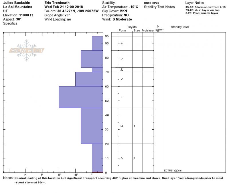
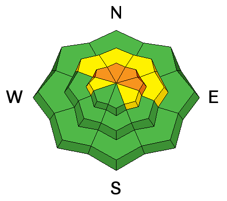
Monday's storm did not provide enough of a load to produce a natural avalache cycle but underlying weak, sugary, faceted snow still exists, particularly at the base of the snowpack. The danger for triggering a persistent slab avalanche up to 3' deep is greatest on steep, upper elevation slopes that face NW-N-E, especially if these slopes are overloaded with recent deposits of wind drifted snow. Human triggered avalanches remain likely in these areas. Addtional snow over the next couple of days will continue to keep the pressure on the snowpack, and backcountry travelers should stick to lower angle terrain. The snowpit below illustrates the unstable base we are dealing with. An extended column test produced propagation failure on weak, faceted snow at the ground. ECTP 21
|
| type | aspect/elevation | characteristics |
|---|

|
|
LIKELIHOOD
LIKELY
UNLIKELY
SIZE
 LARGE
SMALL
TREND
INCREASING DANGER
SAME
DECREASING DANGER
|
|
description
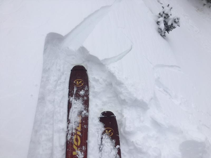
Southerly winds have been blowing and drifting snow since before the storm on Monday and wind slabs are scattered liberally through the high country. Older, harder slabs, covered by more recent snow exist further down slope, while recent fresh drifts continue to form on the leeward sides of upper elevation ridge crests and terrain features. I was able to crack out several drifts yesterday and this trend will continue today with more snow and wind in the forecast. Backcountry travelers should avoid any slope where the snow has a smooth, rounded appearance, or where you can detect recent deposits of wind drifted snow. The danger is greatest in steep slopes right around treeline and above that face NW-N-E. A triggered wind slab has the very real potential to step down causing a deeper and more dangerous persistent slab avalanche.
Frequent cracking in the snow surface was observed yesterday above tree line. |
 |
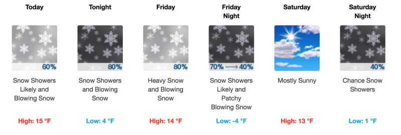
weather We'll be in an active pattern for the next couple of days. 3"-5" of snow are possible today with upwards of a foot accumulation by Saturday morning. High temps at 10,000' today will be in the mid teens, and SW winds will average 15-20 mph with gusts into the 30's along ridge tops.
|
| general announcements The UAC has new support programs with Outdoor Research and Darn Tough. Support the UAC through your daily shopping. When you shop at Smith's, or online at Outdoor Research, REI, Backcountry.com, Darn Tough, Patagonia, NRS, Amazon, eBay a portion of your purchase will be donated to the FUAC. See our Donate Page for more details on how you can support the UAC when you shop. Benefit the Utah Avalanche Center when you buy or sell on eBay - set the Utah Avalanche Center as a favorite non-profit in your eBay account here and click on eBay gives when you buy or sell. You can choose to have your seller fees donated to the UAC, which doesn't cost you a penny This information does not apply to developed ski areas or highways where avalanche control is normally done. This advisory is from the U.S.D.A. Forest Service, which is solely responsible for its content. This advisory describes general avalanche conditions and local variations always occur. |