25th Annual Black Diamond Fall Fundraising Party
Thursday, September 13; 6:00-10:00 PM; Black Diamond Parking Lot
25th Annual Black Diamond Fall Fundraising Party
Thursday, September 13; 6:00-10:00 PM; Black Diamond Parking Lot
| Advisory: Moab Area Mountains | Issued by Eric Trenbeath for Wednesday - February 14, 2018 - 6:45am |
|---|


|
bottom line The avalanche danger remains CONSIDERABLE today on steep slopes facing W-N-E at mid and upper elevations. New snow combined with winds have created dangerous avalanche conditions and human triggered avalanches, 1-3' deep, breaking on buried weak layers are likely in these areas. Cautious route finding and conservative decision making are essential. Stick to low angle slopes, ridge crests, and avoid areas with recently deposited, wind drifted snow.
|
 |
special announcement https://utahavalanchecenter.org/observations/36601 Episode 3 of the UAC podcast is live. We talk with UDOT Avalanche Program Supervisor Bill Nalli on how he and his teams keep the Greatest Snow on Earth from avalanching over the open roads and highways of the state. Check it out on ITunes, Stitcher, the UAC blog, or wherever you get your podcasts. The UAC Marketplace is online. The holiday auction is closed, but our online marketplace still has deals on skis, packs, airbag packs, beacons, snowshoes, soft goods and much more. |
 |
current conditions Skies are cloudy this morning and southerly ridge top winds continue to blow in the 20-25 mph range with gusts into the 30's. It looks like an inch of snow has accumulated at the Geyser Pass Trailhead overnight though Gold Basin is not reporting any new snow. It's currently 29 degrees at Geyser Pass Trailhead, and 19 on Pre Laurel Peak. Yesterday was a bonafide winter day in the mountains with 4-8" of new, heavy, dense snow which is just what we needed for base building. The high density snow made turning possible on lower angle terain and kept us riding high in the snowpack. Conditions are still quite thin, but it finally seems as if we are on our way. Winds have had their way with the high country, and lower angled, sheltered terrain provides the best, and safest source for amusement. For a detailed report on our travels go here. Base depth at Geyser Pass Trailhead: 21" Base depth in Gold Basin: 35" New snow totals in Gold Basin. Snow totals at the Geyser Pass Trailhead, (9600') Wind, temperature, and humidity on Pre Laurel Peak (11,700') Road conditions to Geyser Pass Trailhead: Grand Country plowed yesterday and the road is snowpacked. 4wd is still recommended. Grooming conditions: Matt rolled out the trails into Gold Basin and over Geyser Pass yesterday.
It's finally starting to look like winter up there! |
| type | aspect/elevation | characteristics |
|---|

|

|
LIKELIHOOD
 LIKELY
UNLIKELY
SIZE
 LARGE
SMALL
TREND
 INCREASING DANGER
SAME
DECREASING DANGER
|
|
description
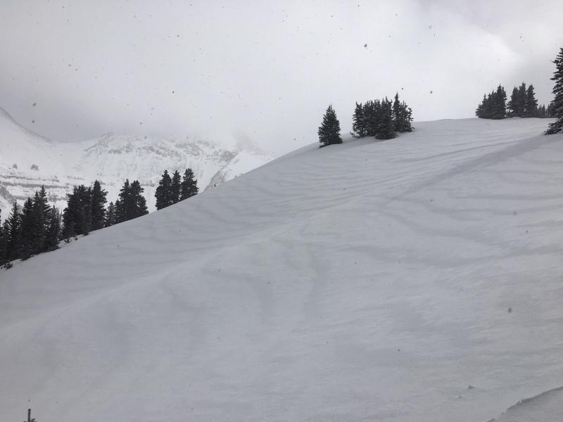
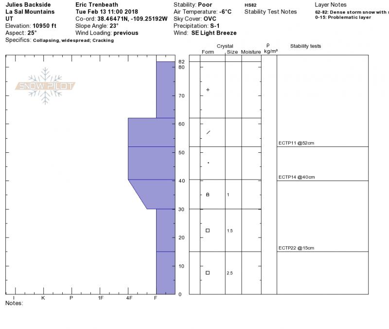
The recent heavy snow combined with strong southerly winds has put the first significant load on our fragile snowpack.Though we haven't yet seen any significant natural activiity, collapsing was widespread yesterday and the addtional weight of a skier or rider is all that is needed today to tip the balance. Areas with weak, unstable snow exist on W-N-E facing slopes at mid and upper elevations, and human triggered avalanches from 1-3' deep are likely in these areas. Addtionally, stability tests yesterday showed that the new snow load has stressed multiple weak layers higher up in the snowpack. It's not a pretty picture, and steep, northerly facing terrain will need to be avoided for the forseeable future.
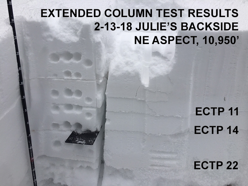
This photo illustrates the layers that propagated with an extended column test.
|
| type | aspect/elevation | characteristics |
|---|

|

|
LIKELIHOOD
LIKELY
UNLIKELY
SIZE
LARGE
SMALL
TREND
INCREASING DANGER
SAME
DECREASING DANGER
|
|
description
Strong winds over the past couple of days have blown the new snow into drifts, often depositing them further down slope than usual. Avoid areas that have a smooth, rounded appearance, and look for signs of instability such as cracking in the snow surface. A triggered wind slab also has the potential to step down creating a deeper, more dangerous, persistent slab avalanche. |
 |
weather Another storm will move into the area this evening bringing snowfall to the mountains overnight. The mountains of central Colorado are favored but it looks like we will pick up another 4-8". Today we'll see a chance for snow, SW winds in the 15-25 mph range, and a high temperature near 30 degrees at 10,000'.
|
| general announcements The UAC has new support programs with Outdoor Research and Darn Tough. Support the UAC through your daily shopping. When you shop at Smith's, or online at Outdoor Research, REI, Backcountry.com, Darn Tough, Patagonia, NRS, Amazon, eBay a portion of your purchase will be donated to the FUAC. See our Donate Page for more details on how you can support the UAC when you shop. Benefit the Utah Avalanche Center when you buy or sell on eBay - set the Utah Avalanche Center as a favorite non-profit in your eBay account here and click on eBay gives when you buy or sell. You can choose to have your seller fees donated to the UAC, which doesn't cost you a penny This information does not apply to developed ski areas or highways where avalanche control is normally done. This advisory is from the U.S.D.A. Forest Service, which is solely responsible for its content. This advisory describes general avalanche conditions and local variations always occur. |