25th Annual Black Diamond Fall Fundraising Party
Thursday, September 13; 6:00-10:00 PM; Black Diamond Parking Lot
25th Annual Black Diamond Fall Fundraising Party
Thursday, September 13; 6:00-10:00 PM; Black Diamond Parking Lot
| Advisory: Moab Area Mountains | Issued by Eric Trenbeath for Friday - January 12, 2018 - 6:42am |
|---|
 |
special announcement This advisory will be updated intermittently with a general conditions report until snow coverage is sufficient for winter travel. Plowing: Grand County plowed the road on Thursday, Jan 11. Grooming: Matt ran the roller on Thursday and will be setting track today. We've scheduled our annual Backcountry 101 avalanche course for Feb 2,3. For more information or to register go here. We've also scheduled a Motorized Backcountry 101 for snowmobiles and snowbikes. For more information or to register go here. |
 |
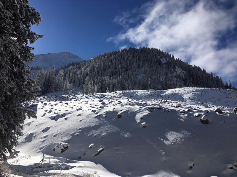
current conditions
It is finally starting to look like winter in the mountains with accumulated snow since Monday totaling 12" at 1.2" of water. Base depth at Geyser Pass Trailhead is 11" and 16" in gold Basin. On Thursday, my partners and I ventured beyond the road into Gold Basin. It was a beautiful day with fresh snow around, but coverage remains exceedingly thin and we never took our skins off. For now, cross country skiing, and snowmobiling on roadways remain the best form of winter recreation and travel. New snow totals in Gold Basin. Snow totals at the Geyser Pass Trailhead, (9600') Wind, temperature, and humidity on Pre Laurel Peak (11,700')
Coverage remains exceedingly thin, and it's going to take at least a couple good storms to make travel conducive in this kind of terrain. |
| type | aspect/elevation | characteristics |
|---|


|

|
LIKELIHOOD
 LIKELY
UNLIKELY
SIZE
 LARGE
SMALL
TREND
 INCREASING DANGER
SAME
DECREASING DANGER
|
|
description
The overall thin coverage, and lack of accessibility to avalanche terrain, do not warrant a danger rating at this time. In most areas the snowpack is simply too shallow and well anchored by brush and rocks to produce an an avalanche. However, the underlying snowpack has already been demonstrating it's inability to support a new load and collapsing and cracking over small areas has been a regular occurrence since our most recent storm cycle. What this means is that we have a developing persistent slab problem where weak, sugary, faceted snow near the ground is providing an unstable base for future snow loads. Most of this weak, faceted snow can be found on northerly facing slopes between about 9500' and 11,500'. The extreme upper elevations were mostly blown clean prior to this last storm, but a few gullies harbor buried, weaker snow. For now, the potential for triggering an avalanche is very remote however, travelers wandering into steep sided gullies, could possibly trigger a shallow avalanche down to the rocks. This condition will only worsen with the next snow load. |
 |
weather Read it and weep... |
| general announcements Support the UAC through your daily shopping. When you shop at Smith's, or online at REI, Backcountry.com, Patagonia, NRS, Amazon, eBay a portion of your purchase will be donated to the FUAC. See our Donate Page for more details on how you can support the UAC when you shop. Benefit the Utah Avalanche Center when you buy or sell on eBay - set the Utah Avalanche Center as a favorite non-profit in your eBay account here and click on eBay gives when you buy or sell. You can choose to have your seller fees donated to the UAC, which doesn't cost you a penny This information does not apply to developed ski areas or highways where avalanche control is normally done. This advisory is from the U.S.D.A. Forest Service, which is solely responsible for its content. This advisory describes general avalanche conditions and local variations always occur. |


 .
.