25th Annual Black Diamond Fall Fundraising Party
Thursday, September 13; 6:00-10:00 PM; Black Diamond Parking Lot
25th Annual Black Diamond Fall Fundraising Party
Thursday, September 13; 6:00-10:00 PM; Black Diamond Parking Lot
| Advisory: Moab Area Mountains | Issued by Eric Trenbeath for Tuesday - March 28, 2017 - 6:42am |
|---|


|
bottom line The avalanche danger is MODERATE this morning, but will rise throughout the day, likely reaching CONSIDERABLE by this afternoon. Human triggered storm snow and wind slab avalanches are possible and backcountry travelers need to be alert to changing conditions. Watch for fresh drifting from wind blown snow, and look for signs of increasing instability such as cracking in the snow surface. The danger will be greatest on steep, upper elevation slopes that face N-E-SE. Duck out of the wind zone and dial back your slope angle as the day progresses.
|
 |
current conditions Last night's welcome rain in town translated to about 7" of new snow up in the mountains. On top of Sunday night's 3"-5" we're now at about a foot of new snow and conditions should be be quite good today. Another 3"-5" is possible today. Northerly winds are suspiciously calm this morning, blowing in the single digits on Pre Laurel Peak. They were also pretty well behaved during the storm averaging only about 10-15 mph and shifting from SE-SW-W. But I'm afraid that's not going to last, expect them to increase into the 20 - 25 mph range with higher gusts as the day progresses. It's currenty 18 degrees on Pre Laurel Peak and 27 at the Geyser Pass Trailhead. Snow totals, temperature and snow/water equivalent at the Geyser Pass Trailhead. (9600') Winds, temperature and humidity on Pre Laurel Peak (11,700')
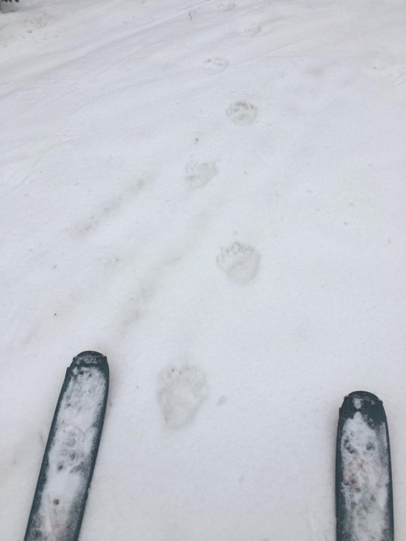
Nice Tracks! It must be spring when the bears are out and about. |
 |
recent activity |
| type | aspect/elevation | characteristics |
|---|

|
|
LIKELIHOOD
 LIKELY
UNLIKELY
SIZE
 LARGE
SMALL
TREND
 INCREASING DANGER
SAME
DECREASING DANGER
|
|
description
With winds expected to increase, watch for a rising wind slab danger today in upper elevation, wind exposed terrain. The danger will be greatest on steep, upper elevation slopes that face N-E-SE. Be alert to changing conditions and look for signs of instability such as cracking in the snow surface. As the day progresses, think about avoiding steep slopes with smooth rounded deposits of wind drifted snow. |
| type | aspect/elevation | characteristics |
|---|

|

|
LIKELIHOOD
LIKELY
UNLIKELY
SIZE
 LARGE
SMALL
TREND
 INCREASING DANGER
SAME
DECREASING DANGER
|
|
description
Today we may see loose, dry sluffs, or cohesive soft slabs running within the new snow on slopes steeper than about 35 degrees. They won't pack a huge punch but they could entrain a fair amount of snow once they get moving. Try your luck on smaller test slopes to se how the snow reacts before jumping into larger terrain. |
 |
weather Today Snow. Patchy blowing snow after 1pm. High near 26. Blustery, with a north wind 5 to 15 mph increasing to 15 to 25 mph in the afternoon. Winds could gust as high as 40 mph. Chance of precipitation is 80%. Total daytime snow accumulation of 3 to 7 inches possible. Tonight A 40 percent chance of snow, mainly before midnight. Widespread blowing snow, mainly between 10pm and 5am. Cloudy during the early evening, then gradual clearing, with a low around 18. Windy, with a north wind 25 to 30 mph, with gusts as high as 50 mph. Wednesday Areas of blowing snow before 1pm. Sunny, with a high near 33. Breezy, with a north northeast wind 15 to 25 mph, with gusts as high as 40 mph. Wednesday Night Mostly clear, with a low around 25. North wind 10 to 15 mph becoming west after midnight. Thursday A chance of snow before 2pm, then a chance of rain and snow between 2pm and 5pm, then a chance of rain after 5pm. Mostly sunny, with a high near 38. Southwest wind 10 to 15 mph, with gusts as high as 25 mph. Chance of precipitation is 30%. Thursday Night Rain and snow likely, becoming all snow after 7pm. Patchy blowing snow after 10pm. Mostly cloudy, with a low around 23. Breezy. Chance of precipitation is 70%. Friday Snow. The snow could be heavy at times. Patchy blowing snow before 8am. High near 29. Chance of precipitation is 80%. |
| general announcements
If you are getting out into the mountains, we love to hear from you! You can SUBMIT OBSERVATIONS ONLINE If you would like to have avalanche advisories emailed to you, SIGN UP HERE Support the Utah Avalanche Center just by buying groceries! Do you buy groceries at City Market? When you register your Kroger rewards card with their Community Rewards program, they will donate to the Utah Avalanche Center whenever you make a purchase. It's easy, only takes a minute, and doesn't cost you anything. Details here. Benefit the Utah Avalanche Center when you shop from Backcountry.com or REI: Click this link for Backcountry.com or this link to REI, shop, and they will donate a percent of your purchase price to the UAC. Both offer free shipping (with some conditions) so this costs you nothing! The information in this advisory is from the US Forest Service which is solely responsible for its content. This advisory describes general avalanche conditions and local variations always occur. |