25th Annual Black Diamond Fall Fundraising Party
Thursday, September 13; 6:00-10:00 PM; Black Diamond Parking Lot
25th Annual Black Diamond Fall Fundraising Party
Thursday, September 13; 6:00-10:00 PM; Black Diamond Parking Lot
| Advisory: Moab Area Mountains | Issued by Eric Trenbeath for Saturday - March 11, 2017 - 6:32am |
|---|

|
bottom line The avalanche danger is generally LOW and mostly stable snow conditions exist. But low danger doesn't mean no danger and we still have a few things to consider. With daytime heating, the potential exists for loose, wet avalanches on steep, sun exposed slopes. If you feel the snow getting wet and sloppy, or if you notice signs of instability such as roller balls or pinwheels, get off of, and out from under steep slopes. it may still be possible to trigger an isolated wind slab, or persistent slab avalanche in areas of more extreme, upper elevation, northerly facing terrain. Carefully evaluate individual slopes for smooth hard slabs, with weak, underlying snow if you venture into this type of terrain.
|
 |
special announcement Banff Mountain Film Festival World Tour Returns to Moab, March 13, 14. Featuring the year’s best films on mountain sport, culture and adventure, this will be the 14th season the festival has come to Moab. Proceeds support the Utah Avalanche Center - Moab and Second Chance Wildlife Rehabilitation. For more info and to purchase tickets, go here. |
 |
current conditions
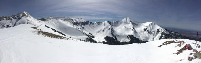
A weak disturbance to the north has spread a few residual clouds over our area this morning. We've had a pretty good re-freeze above 10,000' and temperatures are in the high 20's, but it's a warm 36 degrees at the Geyser Pass Trailhead. NW winds are in the 20 mph range along ridge tops. Snow conditions are a mixed bag though the dedicated enthusiast can still find something to get excited about. Corn-like snow can be found on SE-W aspects - work the sun for best results and finish up before the snow becomes wet an sloppy - while northerly aspects offer a variety of conditions from wind affected to soft, settled powder. Wind, temperature and humidity on Pre Laurel Peak. (11,700') Storm totals and temperature in Gold Basin. (10,000') Snow totals, temperature and snow/water equivalent at the Geyser Pass Trailhead. (9600')
Decent turning conditons can still be found amongst the wind affected snow in the high country. |
 |
recent activity |
| type | aspect/elevation | characteristics |
|---|

|
|
LIKELIHOOD
 LIKELY
UNLIKELY
SIZE
 LARGE
SMALL
TREND
 INCREASING DANGER
SAME
DECREASING DANGER
|
|
description
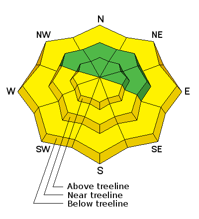
With soaring temperatures today, the danger for loose wet slide activity will increase on sun exposed slopes. Look for signs of instability such as roller balls or pinwheels, and of course, natural, loose wet slide activity. Stay off of and out from under steep, sun exposed slopes if any of these signs are present, or if the snow is wet and sloppy over your boot tops. |
| type | aspect/elevation | characteristics |
|---|

|
|
LIKELIHOOD
 LIKELY
UNLIKELY
SIZE
 LARGE
SMALL
TREND
 INCREASING DANGER
SAME
DECREASING DANGER
|
|
description
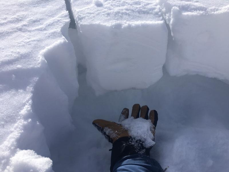
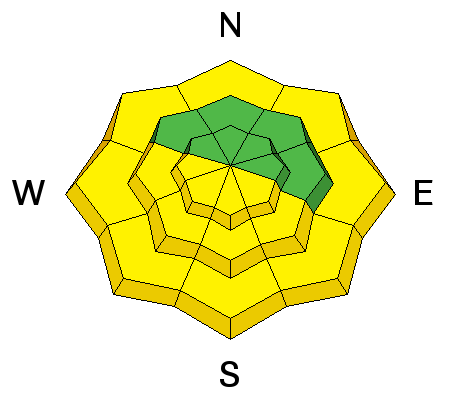
In our travels through the high country on Thursday, Manti-Skyline forecaster Brett Kobernik and I found generally stable snow conditons. As always however, low danger doens't mean no danger and here are a few things to consider when traveling in avalanche terrain. Wind Slab: Extreme, upper elevation, wind exposed terrain still harbors the occasional wind slab. If you push into this type of terrain, carefully evaluate wind rolls, and hard, hollow feeling slabs. Persistent Slab: In general, snowpits and stabilty tests have shown a stabilization of the early February, faceted weak layer. We did however, run across an area of very weak snow on a NE aspect around 11,500'. The slope was a repeat running slide path in an alpine bowl, and it appeared to be the exception rather than the rule. But if you find yourself contemplating a steep line on a northerly facing aspect, probe around with your pole for underlying weak facets. If you find them, and there is a slab on top, reconsider your slope selection.
Weak, faceted snow still exists in isolated areas. Close up photo by Brett Kobernik. |
 |
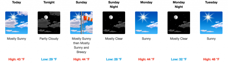
weather A few clouds will move through the area this morning as a shortwave trough passes by to the north. Today we'll see mostly sunny skies, light NW winds, and high temperatures in the mid 40's at 10,000'. A second shortwave will move through to the north early Sunday morning followed by high pressure for the up coming week.
|
| general announcements
Grooming: Trails have not been groomed. If you are getting out into the mountains, we love to hear from you! You can SUBMIT OBSERVATIONS ONLINE If you would like to have avalanche advisories emailed to you, SIGN UP HERE Support the Utah Avalanche Center just by buying groceries! Do you buy groceries at City Market? When you register your Kroger rewards card with their Community Rewards program, they will donate to the Utah Avalanche Center whenever you make a purchase. It's easy, only takes a minute, and doesn't cost you anything. Details here. Benefit the Utah Avalanche Center when you shop from Backcountry.com or REI: Click this link for Backcountry.com or this link to REI, shop, and they will donate a percent of your purchase price to the UAC. Both offer free shipping (with some conditions) so this costs you nothing! The information in this advisory is from the US Forest Service which is solely responsible for its content. This advisory describes general avalanche conditions and local variations always occur. |


 .
.