25th Annual Black Diamond Fall Fundraising Party
Thursday, September 13; 6:00-10:00 PM; Black Diamond Parking Lot
25th Annual Black Diamond Fall Fundraising Party
Thursday, September 13; 6:00-10:00 PM; Black Diamond Parking Lot
| Advisory: Moab Area Mountains | Issued by Eric Trenbeath for Tuesday - February 28, 2017 - 7:02am |
|---|

|
bottom line The avalanche danger is MODERATE on steep wind drifted slopes. It may also be possible to trigger an avalanche on a buried persistent weak layer. The danger is most prominent on slopes that face the north half of the compass, but with gusty winds in excess of 40 mph, cross loading will be a factor on all aspects at upper elevations. Suspect the leeward sides of terrain features such as gully walls and sub ridges, and be wary of steep convexities, and blind break-overs. Avoid steep slopes with smooth rounded deposits of wind drifted snow.
|
 |
special announcement Earlier this month, Colorado experienced a snowbike fatality. This is the newest user group to venture into avalanche terrain, and we have several snowbikes here in Moab. It's a tragic story, and a complex situation where the victim had an airbag but wasn't wearing a beacon. Read the story in the official report from the Colorado Avalanche Information Center. |
 |
current conditions Rather than finding fresh powder this morning, you are more likely to encounter a surface representing craters of the moon, especially in wind exposed terrain. For all the pomp and circumstance surrounding this latest storm, Gold Basin is only reporting about 4" of new snow, most of which fell yesterday afternoon. Adding insult to injury, SW winds nuked all day yesterday in the 30-40 mph with gusts to 50. They've backed off a little this morning and are beginning to shift to the NW. 10,000' temperatures are in the mid to upper teens. For recent observations go here. Wind, temperature and humidity on Pre Laurel Peak. (11,700') Storm totals and temperature in Gold Basin. (10,000') Snow totals, temperature and snow/water equivalent at the Geyser Pass Trailhead. (9600') |
 |
recent activity |
| type | aspect/elevation | characteristics |
|---|

|

|
LIKELIHOOD
 LIKELY
UNLIKELY
SIZE
 LARGE
SMALL
TREND
 INCREASING DANGER
SAME
DECREASING DANGER
|
|
description
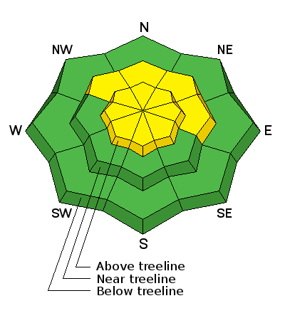
Wind slab, wind slab, wind slab. A combination of wind slabs old and new will be your primary concern out there today. Expect to find them liberally scattered throughout the high country on the leeward sides of ridge crests and terrain features such as sub ridges, gully walls or rock buttresses. A subtle variation in terrain can make all the difference, and in some cases, a stiff wind slab may exist adjacent to a scoured surface or even exposed ground. Upwards of a foot of snow has been lying around, available for transport, and with winds of this intensity, drifts will have formed farther down slope than usual. Suspect any steep slope with smooth rounded deposits of wind drifted snow, and avoid slopes with steep convexities and blind break-overs. |
| type | aspect/elevation | characteristics |
|---|

|
|
LIKELIHOOD
 LIKELY
UNLIKELY
SIZE
LARGE
SMALL
TREND
INCREASING DANGER
SAME
DECREASING DANGER
|
|
description
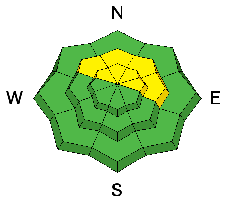
Weak, faceted snow layers in the upper portion of the snowpack have begun to turn up in some areas. So far they have primarily been found on Northwesterly aspects right around treeline. In some cases, it may be possible to trigger a wind slab down to this buried weak layer. Slopes to avoid remain those that have wind slab concerns, or those that have a northerly aspect. I'll be working on determining how widespread this problem is over the next several days. |
 |
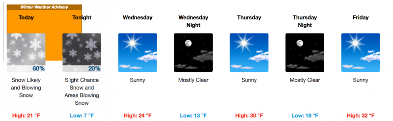
weather Today look for lingering snow showers and cloudy skies with maybe and inch or two possible. WNW winds will be on the increase today blowing in the 15-20 mph. High temperature at 10,000' will be near 20 degrees. This system will exit the area tonight with sunny weather and warming conditions on tap for the rest of the week.
|
| general announcements Road conditions: Grand County plans to plow the road on Wednesday. It has been passable for vehicles with all wheel drive, but you may encounter fresh drifts across the road today. Longtime local skier Craig Bigler lost a ski in the North Woods on Thursday. If you run across it please give him a call at 435-260-1007. If you are getting out into the mountains, we love to hear from you! You can SUBMIT OBSERVATIONS ONLINE If you would like to have avalanche advisories emailed to you, SIGN UP HERE Support the Utah Avalanche Center just by buying groceries! Do you buy groceries at City Market? When you register your Kroger rewards card with their Community Rewards program, they will donate to the Utah Avalanche Center whenever you make a purchase. It's easy, only takes a minute, and doesn't cost you anything. Details here. Benefit the Utah Avalanche Center when you shop from Backcountry.com or REI: Click this link for Backcountry.com or this link to REI, shop, and they will donate a percent of your purchase price to the UAC. Both offer free shipping (with some conditions) so this costs you nothing! The information in this advisory is from the US Forest Service which is solely responsible for its content. This advisory describes general avalanche conditions and local variations always occur. |