25th Annual Black Diamond Fall Fundraising Party
Thursday, September 13; 6:00-10:00 PM; Black Diamond Parking Lot
25th Annual Black Diamond Fall Fundraising Party
Thursday, September 13; 6:00-10:00 PM; Black Diamond Parking Lot
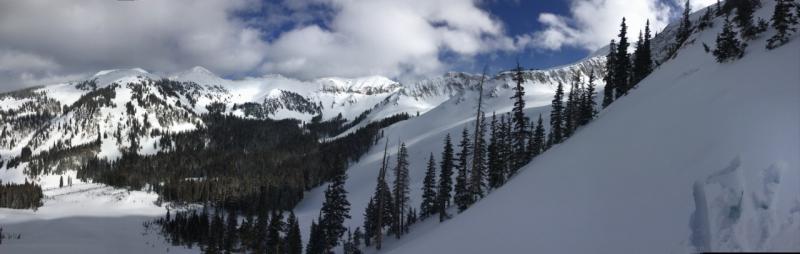
| Advisory: Moab Area Mountains | Issued by Eric Trenbeath for Monday - February 27, 2017 - 6:57am |
|---|


|
bottom line The avalanche danger is MODERATE on steep wind drifted slopes. It may also be possible to trigger an avalanche on a buried persistent weak layer. With a storm on the horizon, expect the danger to rise over the next 24 hours. The danger is most prominent on slopes that face the north half of the compass, but with gusty winds in excess of 40 mph, cross loading may be a factor on all aspects at upper elevations. Suspect the leeward sides of terrain features such as gully walls and sub ridges, and be wary of steep convexities, and blind break-overs.
|
 |
special announcement Earlier this month, Colorado experienced a snowbike fatality. This is the newest user group to venture into avalanche terrain, and we have several snowbikes here in Moab. It's a tragic story, and a complex situation where the victim had an airbag but wasn't wearing a beacon. Read the story in the official report from the Colorado Avalanche Information Center. |
 |
current conditions
Snow totals since Wednesday are up to around a foot above 10,000'. Southerly winds have been cranking overnight averaging 3-40 mph with gusts as high as 50 mph along ridge tops. In my travels into the alpine on Saturday, I found dense, slightly wind affected powder that is starting to pile up enough to make the bottom disappear. Sheltered, low angle, north facing terrain offered the best turning condiitons. For other recent observations go here. Wind, temperature and humidity on Pre Laurel Peak. (11,700') Storm totals and temperature in Gold Basin. (10,000') Snow totals, temperature and snow/water equivalent at the Geyser Pass Trailhead. (9600') |
 |
recent activity |
| type | aspect/elevation | characteristics |
|---|

|
|
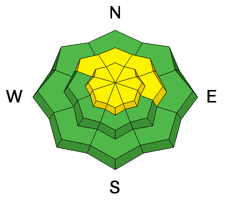
LIKELIHOOD
 LIKELY
UNLIKELY
SIZE
 LARGE
SMALL
TREND
 INCREASING DANGER
SAME
DECREASING DANGER
|
|
description
South and westerly winds have continued to move snow around, and wind slabs old and new exist on the leeward sides of ridge crests and terrain features in wind exposed terrain. Today you will need to be alert to changing conditions as fresh drifts continue to from. Look for signs of instability such as cracking in the snow surface, and avoid steep slopes that have smooth, rounded deposits of wind drifted snow. |
| type | aspect/elevation | characteristics |
|---|

|

|
LIKELIHOOD
 LIKELY
UNLIKELY
SIZE
LARGE
SMALL
TREND
INCREASING DANGER
SAME
DECREASING DANGER
|
|
description
The snowpack is starting to show some signs of weakness, and on Sunday, a party reported a collapse on a mid elevation, west facing slope. See their report here. And on Friday, Dave Garcia identified a buried, one finger slab on top of a weak faceted layer a little over a foot below the surface. This was on a NW aspect at about 11,000'. This weak layer hasn't yet proven to be reactive, but in some areas the foot or so of snow we've received over the past several days, combined with the weight of a skier or rider, may be enough to trigger an avalanche. I'm not certain how widespread this weak layer is. The only way to know for sure is to dig down and look for it if you plan to venture into suspect terrain. |
 |
weather An approaching storm will begin to impact the area Monday morning with weather impacts through Tuesday bringing more widespread snowfall to the region. Winter Storm Highlights are currently in effect for Monday morning through Tuesday evening. The weather pattern will remain cooler than normal with an unsettled northwest flow through much of next week. Monday Snow showers likely, mainly after 3pm. Cloudy, with a high near 30. Windy, with a south southwest wind 20 to 30 mph, with gusts as high as 50 mph. Chance of precipitation is 70%. New snow accumulation of 2 to 4 inches possible. Monday Night Snow showers likely. Widespread blowing snow, mainly before 10pm. Cloudy, with a low around 13. Windy, with a west wind 25 to 30 mph decreasing to 15 to 20 mph after midnight. Winds could gust as high as 55 mph. Chance of precipitation is 70%. New snow accumulation of 3 to 5 inches possible. Tuesday Snow showers likely, mainly before 11am. Patchy blowing snow between 10am and 11am. Cloudy, with a high near 15. Blustery, with a west wind 10 to 20 mph, with gusts as high as 30 mph. Chance of precipitation is 60%. New snow accumulation of 1 to 3 inches possible. Tuesday Night A 20 percent chance of snow showers before 11pm. Partly cloudy, with a low around 7. Blustery, with a northwest wind 15 to 20 mph. Wednesday Sunny, with a high near 20. |
| general announcements Road conditions: The road to Geyser Pass Trailhead has not been plowed this week but vehicles with all wheel drive shouldn't enounter any problems. Expect snow packed conditions. Longtime local skier Craig Bigler lost a ski in the North Woods on Thursday. If you run across it please give him a call at 435-260-1007. If you are getting out into the mountains, we love to hear from you! You can SUBMIT OBSERVATIONS ONLINE If you would like to have avalanche advisories emailed to you, SIGN UP HERE Support the Utah Avalanche Center just by buying groceries! Do you buy groceries at City Market? When you register your Kroger rewards card with their Community Rewards program, they will donate to the Utah Avalanche Center whenever you make a purchase. It's easy, only takes a minute, and doesn't cost you anything. Details here. Benefit the Utah Avalanche Center when you shop from Backcountry.com or REI: Click this link for Backcountry.com or this link to REI, shop, and they will donate a percent of your purchase price to the UAC. Both offer free shipping (with some conditions) so this costs you nothing! The information in this advisory is from the US Forest Service which is solely responsible for its content. This advisory describes general avalanche conditions and local variations always occur. |