25th Annual Black Diamond Fall Fundraising Party
Thursday, September 13; 6:00-10:00 PM; Black Diamond Parking Lot
25th Annual Black Diamond Fall Fundraising Party
Thursday, September 13; 6:00-10:00 PM; Black Diamond Parking Lot
| Advisory: Moab Area Mountains | Issued by Eric Trenbeath for Friday - February 10, 2017 - 6:06am |
|---|


|
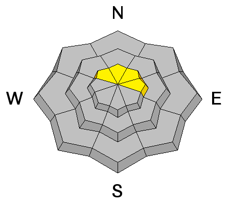
bottom line Today there remains a MODERATE danger for wet slide activity on slopes that received significant heating yesterday. Cloud cover today will help keep the threat at bay, but the lack of an overnight refreeze has complicated the issue. Avoid steep, "punchy" slopes that have sloppy wet snow, and look for signs of instability such as roller balls, pinwheels, or loose snow sluffing beneath you. There is also a MODERATE danger for triggering a recently deposited wind slab on upper elevation, northerly aspects.
|
 |
special announcement |
 |
current conditions Conditions continue to be a mixed bag out there with warm temperatures being the biggest factor of late. Yesterday I found very sloppy snow conditions on sun exposed slopes while Dave Garcia reported finding a brief window with corn-like conditions over on the SE face of Mount Peale. Cloud cover today will help keep the threat of loose wet slide activity at bay, but the lack of an overnight freeze at mid and lower elevations will complicate the issue, and slopes that were sloppy yesterday will be punchy this morning. Upper elevation, northerly aspects experienced a little refresh from Tuesday night's couple of inches of new snow. Southwest winds overnight have been on the increase averaging 20-30 mph with gusts into the 40's along ridge tops. It's currently 32 degrees on Pre Laurel Peak, 40 in Gold Basin, and 44 at the Geyser Pass Trailhead. Wind, temperature and humidity on Pre Laurel Peak. (11,700') Storm totals and temperature in Gold Basin. (10,000') Snow totals, temperature and snow/water equivalent at the Geyser Pass Trailhead. (9600')
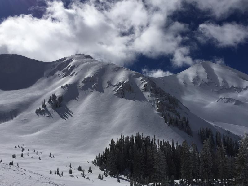
Upper elevation, northerly aspects, in addition to being very filled in, have the smooth, pillowy appearance of recently deposited, wind drifted snow. South and westerly aspects, like the slope in the foreground, are sun baked and wind scoured. |
 |
recent activity |
| type | aspect/elevation | characteristics |
|---|

|

|
LIKELIHOOD
 LIKELY
UNLIKELY
SIZE
 LARGE
SMALL
TREND
 INCREASING DANGER
SAME
DECREASING DANGER
|
|
description
Cloud cover today will help keep the threat of loose wet slide activity at bay, but the lack of an overnight refreeze at mid and lower elevations will complicate the issue. Avoid steep slopes where you punch through into sloppy wet snow underneath, and look for signs of instability such as roller balls, pinwheels, or loose snow sluffing beneath you.
If you find yourself cutting trenches in the slop and sending roller balls down the hill, you are at risk for triggering a loose wet slide. |
| type | aspect/elevation | characteristics |
|---|

|
|
LIKELIHOOD
LIKELY
UNLIKELY
SIZE
LARGE
SMALL
TREND
 INCREASING DANGER
SAME
DECREASING DANGER
|
|
description
In my travels yesterday, I was surprised to observe pillowy looking surfaces, indicative of fresh wind slabs, on upper elevation northerly aspects. Tuesday night's "storm" deposited less then 2" of snow at the Gold Basin study plot, but there must have been a little more up high. Warm temperatures over the past couple of days will have helped stabilize these shallow, fresh wind slabs, but approach any smooth, rounded pillow with caution, particularly in areas of high consequence terrain.
Pillowy snow in Talking Mountain Cirque. (Dave Garcia photo) |
 |
weather A warm, moist storm system will move into the region this evening with our best chance for snow coming on Saturday. Though it looks like significant snow for the San Juan Mountains, models disagree on what we'll see here. I'll keep you posted. Today Cloudy, with a high near 42. Breezy, with a southwest wind 20 to 25 mph, with gusts as high as 45 mph. Tonight Snow likely, mainly after 11pm. Areas of blowing snow after 11pm. Cloudy, with a low around 26. Breezy, with a west southwest wind 15 to 25 mph, with gusts as high as 40 mph. Chance of precipitation is 70%. New snow accumulation of 2 to 4 inches possible. Saturday Snow. The snow could be heavy at times. Patchy blowing snow before 10am. High near 31. Breezy, with a west southwest wind 10 to 20 mph. Chance of precipitation is 90%. New snow accumulation of 5 to 9 inches possible. Saturday Night Snow likely, mainly before 11pm. Mostly cloudy, with a low around 20. North northeast wind around 10 mph. Chance of precipitation is 70%. New snow accumulation of 3 to 5 inches possible. Sunday Snow likely, mainly after 11am. The snow could be heavy at times. Partly sunny, with a high near 29. East wind around 10 mph becoming south in the afternoon. Chance of precipitation is 60%. |
| general announcements Road conditions: The road to Geyser Pass Trailhead is plowed with a mix of packed snow, dirt, and mud at lower elevations. If you are getting out into the mountains, we love to hear from you! You can SUBMIT OBSERVATIONS ONLINE If you would like to have avalanche advisories emailed to you, SIGN UP HERE Support the Utah Avalanche Center just by buying groceries! Do you buy groceries at City Market? When you register your Kroger rewards card with their Community Rewards program, they will donate to the Utah Avalanche Center whenever you make a purchase. It's easy, only takes a minute, and doesn't cost you anything. Details here. Benefit the Utah Avalanche Center when you shop from Backcountry.com or REI: Click this link for Backcountry.com or this link to REI, shop, and they will donate a percent of your purchase price to the UAC. Both offer free shipping (with some conditions) so this costs you nothing! The information in this advisory is from the US Forest Service which is solely responsible for its content. This advisory describes general avalanche conditions and local variations always occur. |