25th Annual Black Diamond Fall Fundraising Party
Thursday, September 13; 6:00-10:00 PM; Black Diamond Parking Lot
25th Annual Black Diamond Fall Fundraising Party
Thursday, September 13; 6:00-10:00 PM; Black Diamond Parking Lot
| Advisory: Moab Area Mountains | Issued by Eric Trenbeath for Saturday - January 28, 2017 - 6:31am |
|---|

|
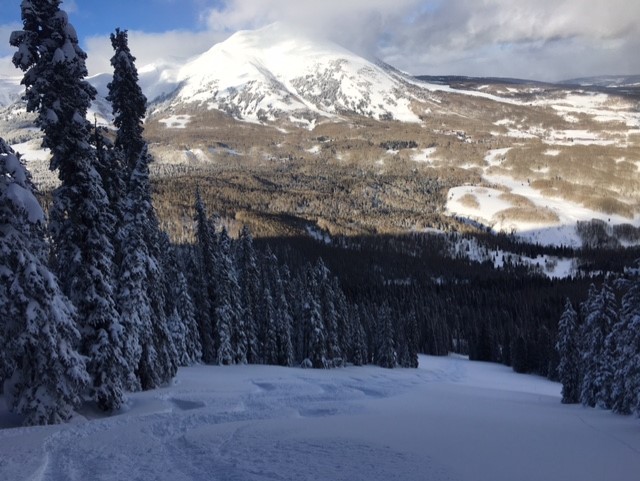
bottom line Today there is a MODERATE avalanche danger for wind slabs old and new on all aspects in steep, wind exposed terrain. Avoid steep slopes that have areas of wind drifted snow. There is also a MODERATE danger for triggering a deeper, persistent slab avalanche. Upper-mid elevation, northerly facing aspects are the most suspect, particularly in areas of steep, rocky, heavily featured terrain. Low elevation terrain offers mostly LOW danger.
|
 |
special announcement
Do you buy groceries at City Market? When you register your Kroger rewards card with their Community Rewards program, they will donate to the Utah Avalanche Center whenever you make a purchase. It's easy, only takes a minute, and doesn't cost you anything. Details here. Road Conditions: Grand County pushed through one lane up to the trailhead on Monday and the road is passable. Backcountry 101 Avalanche Class We will be offering a Backcountry 101 avalanche class on Feb 3, 4. This course will include a night classroom session and a day in the field. Cost is $125 with proceeds to benefit the Utah Avalanche Center Moab. For more information or to sign up go here. |
 |
current conditions The main story over the past 24 hours has been the NE winds, and plumes of snow streaming off the peaks have been clearly visible from town. Blowing mostly in the 10-20 mph range along ridge tops, gusts have reached into the 30's and even high 40's. These blasts have unfortunately taken a toll on the snow surface on exposed, northerly facing slopes, while depositing shallow drifts and wind slabs on southerly aspects. Best bet today will be to seek out sheltered mid, and lower elevation terrain. Mountain temperatures are about 10 degrees warmer this morning and it's currently 18 degrees at the Geyser Pass Trailhead, and 14 on Pre Laurel Peak. Wind, temperature and humidity on Pre Laurel Peak.(11,700') Storm totals and temperature in Gold Basin.(10,000') Snow totals, temperature and snow/water equivalent at the Geyser Pass Trailhead. (9600')
On Thursday, we found excellent powder conditions over on South Mountain. Sheltered mid and lower elevation slopes will be the ticket today. |
 |
recent activity |
| type | aspect/elevation | characteristics |
|---|

|
|
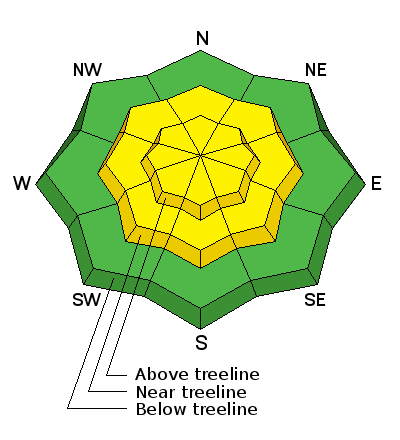
LIKELIHOOD
 LIKELY
UNLIKELY
SIZE
 LARGE
SMALL
TREND
 INCREASING DANGER
SAME
DECREASING DANGER
|
|
description
Wind slabs old and new continue to be the primary concern. Northeast winds have deposited shallow wind drifts on southerly aspects, primarily in upper elevation terrain. Mostly shallow and manageable, they'll be a bit more stubborn today, but be alert to areas of wind drifted snow on the lee sides of ridge crests and terrain features, and look for areas of cross loading on the sides of gully walls and sub-ridges. It may also still be possible to trigger an older, deeper wind slab that formed during the storm cycle of last weekend. Very strong, southwest winds on Monday deposited vast amounts of snow on to leeward, northerly aspects. Most of these slabs are pretty well stuck in place, but there could be an isolated fat pocket here in there that could break out and take you for an ugly ride. Pay attention to smooth rounded pillows of snow, especially if they sound hollow like a drum, and avoid wind loaded slopes with steep convexities. |
| type | aspect/elevation | characteristics |
|---|

|

|
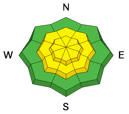
LIKELIHOOD
LIKELY
UNLIKELY
SIZE
 LARGE
SMALL
TREND
INCREASING DANGER
SAME
DECREASING DANGER
|
|
description
Heavy snowfall and wind loading last weekend increased the stress on buried weak layers and several slides broke down into older snow. The snowpack has begun to adjust to this new load, but steep terrain should still be approached with caution. Upper-mid elevation, northerly facing aspects are the most suspect, particularly in areas of steep, rocky, heavily featured terrain. |
 |
weather High pressure is building over the region and temperatures should gradually warm over the next few days. The long range shows a hint at precipitation by late next week. Today Sunny, with a high near 23. Wind chill values as low as -10. Northeast wind 10 to 15 mph becoming south in the afternoon. Tonight Mostly clear, with a low around 7. North wind 10 to 15 mph. Sunday Sunny, with a high near 28. North northeast wind 5 to 10 mph. Sunday Night Mostly clear, with a low around 17. West northwest wind around 5 mph. Monday Sunny, with a high near 31. Northwest wind around 5 mph. |
| general announcements Road Conditions: The road to Geyser Pass Trailhead is plowed but down to one lane in places. The Forest Service will be bringing in equipment on Tuesday to widen it, and the road will be closed all day. Grooming: LUNA will be having a shoveling party today to clear drifts from the end of the Gold Basin Road and they are looking for volunteers to help. Those interested should meet at the Geyser Pass Traihead today at 9:30. If you are getting out into the mountains, we love to hear from you! You can SUBMIT OBSERVATIONS ONLINE If you would like to have avalanche advisories emailed to you, SIGN UP HERE Benefit the Utah Avalanche Center when you shop from Backcountry.com or REI: Click this link for Backcountry.com or this link to REI, shop, and they will donate a percent of your purchase price to the UAC. Both offer free shipping (with some conditions) so this costs you nothing! The information in this advisory is from the US Forest Service which is solely responsible for its content. This advisory describes general avalanche conditions and local variations always occur. |