25th Annual Black Diamond Fall Fundraising Party
Thursday, September 13; 6:00-10:00 PM; Black Diamond Parking Lot
25th Annual Black Diamond Fall Fundraising Party
Thursday, September 13; 6:00-10:00 PM; Black Diamond Parking Lot
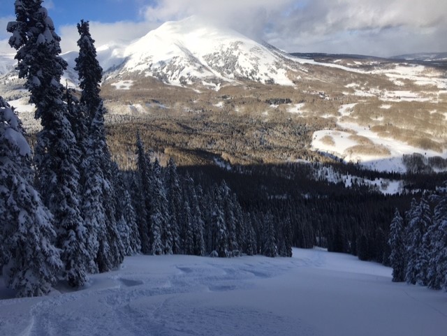
| Advisory: Moab Area Mountains | Issued by Eric Trenbeath for Friday - January 27, 2017 - 6:50am |
|---|

|
bottom line Areas of CONSIDERABLE danger remain in steep, upper-mid to upper elevation terrain that faces NW-NE-SE. Avoid steep slopes in these areas that have smooth rounded deposits of wind drifted snow. Steep, heavily featured, rocky terrain should also be avoided where the danger exists for triggering a deeper persistent slab avalanche. With increasing northerly winds there will be MODERATE danger for newly formed wind slabs on southerly aspects.
|
 |
special announcement
Do you buy groceries at City Market? When you register your Kroger rewards card with their Community Rewards program, they will donate to the Utah Avalanche Center whenever you make a purchase. It's easy, only takes a minute, and doesn't cost you anything. Details here. Road Conditions: Grand County pushed through one lane up to the trailhead on Monday and the road is passable. Backcountry 101 Avalanche Class We will be offering a Backcountry 101 avalanche class on Feb 3, 4. This course will include a night classroom session and a day in the field. Cost is $125 with proceeds to benefit the Utah Avalanche Center Moab. For more information or to sign up go here. |
 |
current conditions Scattered flurries over the past 48 hours have dusted the mountains with just under 2" of new snow. Light NE winds overnight have increased to 15-20 mph along ridge tops this morning. Temperature at the Geyser Pass Trailhead is 10 degrees, and it's a frigid -3 on Pre Laurel Peak. It's now been week since our biggest storm cycle of the year began, and we received about 40" of snow between last Thursday and Monday. On Monday, we saw very strong southwest winds gusting to 70 mph and I feared the worst. But in our travels to the south end of the range yesterday, we found that excellent settled powder conditions exist on all aspects out of the wind zone. Though the sun peeked out a bit, cold temperatures kept the snow dry on southerly aspects as well. Wind, temperature and humidity on Pre Laurel Peak.(11,700') Storm totals and temperature in Gold Basin.(10,000') Snow totals, temperature and snow/water equivalent at the Geyser Pass Trailhead. (9600')
Excellent powder exists in sheltered terrain. |
 |
recent activity On Saturday, a party remotely triggered this avalanche on a north facing slope at 10,400'. The avalanche likely failed on buried near surface facets under the load of new storm snow, eventually stepping down to deeper faceted layers around rocks.
Photo courtesy of James "Jimbo" Collins who was out flying around. |
| type | aspect/elevation | characteristics |
|---|

|
|
LIKELIHOOD
 LIKELY
UNLIKELY
SIZE
 LARGE
SMALL
TREND
 INCREASING DANGER
SAME
DECREASING DANGER
|
|
description
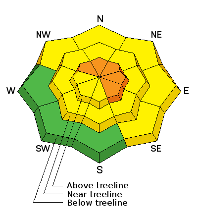
Strong winds and heavy snowfall from last weekend's storm event have created deep wind slabs on the lee sides of ridge crests and terrain features in upper elevation, wind exposed terrain. These are gaining strength, but I would continue to avoid, steep, wind drifted slopes, particularly those that face NW-NE-SE. A triggered wind slab in these areas, up to 3' deep, would make for a very dangerous ride. Avoid smooth rounded deposits of wind drifted snow, and be especially wary of blind convexities that lure you far down slope to where triggered slabs can break well above you. Additionally, blowing snow from increasing northerly winds will form sensitive shallow wind slabs on southerly aspects. Mostly manageable, you'll still want to be on the lookout for fresh deposits on the lee sides ridge crests and terrain features. |
| type | aspect/elevation | characteristics |
|---|

|
|
LIKELIHOOD
 LIKELY
UNLIKELY
SIZE
 LARGE
SMALL
TREND
 INCREASING DANGER
SAME
DECREASING DANGER
|
|
description
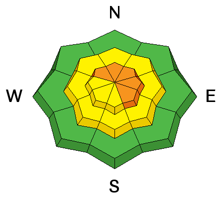
Heavy snowfall and wind loading last weekend have increased the stress on buried weak layers. The snowpack has begun to adjust to this new load, but steep terrain should still be approached with caution. Upper-mid elevation, northerly facing aspects are the most suspect, particularly in areas of steep, rocky, heavily featured terrain. |
 |
weather Today Patchy fog before 9am. Otherwise, sunny, with a high near 20. Wind chill values as low as -30. Northeast wind around 10 mph, with gusts as high as 20 mph. Tonight Mostly clear, with a low around -1. Wind chill values as low as -15. North northeast wind 10 to 15 mph, with gusts as high as 30 mph. Saturday Sunny, with a high near 27. Wind chill values as low as -15. North wind 5 to 10 mph. Saturday Night Mostly clear, with a low around 6. North wind 5 to 10 mph. Sunday Sunny, with a high near 31. North wind 5 to 10 mph. |
| general announcements Road Conditions: The road to Geyser Pass Trailhead is plowed but down to one lane in places. The Forest Service will be bringing in equipment early next week to widen it. Grooming: The lower meadow and out to the Gold Basin yurt has been rolled out, but the rest of the road into Gold Basin is impassable due to heavy drifting. LUNA is organizing a shoveling party to dig it out on Saturday. If you are getting out into the mountains, we love to hear from you! You can SUBMIT OBSERVATIONS ONLINE If you would like to have avalanche advisories emailed to you, SIGN UP HERE Benefit the Utah Avalanche Center when you shop from Backcountry.com or REI: Click this link for Backcountry.com or this link to REI, shop, and they will donate a percent of your purchase price to the UAC. Both offer free shipping (with some conditions) so this costs you nothing! The information in this advisory is from the US Forest Service which is solely responsible for its content. This advisory describes general avalanche conditions and local variations always occur. |