25th Annual Black Diamond Fall Fundraising Party
Thursday, September 13; 6:00-10:00 PM; Black Diamond Parking Lot
25th Annual Black Diamond Fall Fundraising Party
Thursday, September 13; 6:00-10:00 PM; Black Diamond Parking Lot
| Advisory: Moab Area Mountains | Issued by Eric Trenbeath for Tuesday - January 24, 2017 - 6:53am |
|---|

|
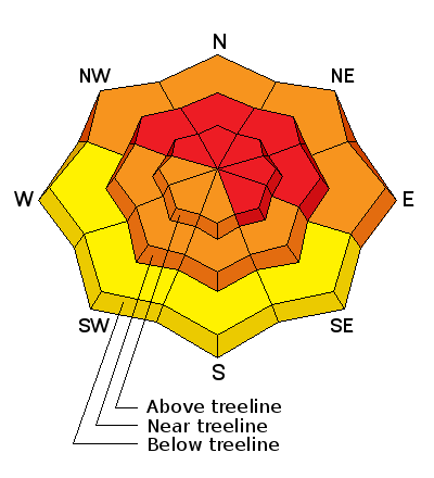
bottom line The avalanche danger is HIGH in upper elevation, wind drifted terrain and natural and human triggered avalanches are likely. Backcountry travelers should avoid avalanche terrain by staying off of and out from under steep slopes. The danger will be greatest on slopes that have a NW-N-E aspect, but drifting snow and freshly formed wind slabs will be found on all aspects in the wind zone. At mid elevations, the avalanche danger is CONSIDERABLE and human triggered avalanches are likely. Stick to sheltered, low angle terrain if you must be out in the mountains today.
|
 |
special avalanche bulletin Heavy snowfall and strong winds have created dangerous avalanche conditions in the mountains today. Backcountry travelers need to possess excellent route finding skills. Travel in avalanche terrain is not recommended. |
 |
special announcement Road Conditions: Grand County pushed through one lane up to the trailhead on Monday and the road is passable. Backcountry 101 Avalanche Class We will be offering a Backcountry 101 avalanche class on Feb 3, 4. This course will include a night classroom session and a day in the field. Cost is $125 with proceeds to benefit the Utah Avalanche Center Moab. For more information or to sign up go here. |
 |
current conditions Heavy snowfall and strong winds have created dangerous avalanche conditions and areas of deep drifted snow, alternating with scoured zones and thick wind crusts. Backcountry travel is not only dangerous but difficult. All told, the mountains have received 40" of snow above 10,000' since Thursday night, and it's a shame what the winds have done to it. Yesterday, southerly winds averaged 30-40 mph for several hours with regular gusts over 70. Use the links below for current wind, snow totals, and temperature. Wind, temperature and humidity on Pre Laurel Peak.(11,700') Storm totals and temperature in Gold Basin.(10,000') Snow totals, temperature and snow/water equivalent at the Geyser Pass Trailhead. (9600') |
 |
recent activity On Saturday, a party remotely triggered this avalanche on a north facing slope at 10,400'. The avalanche likely failed on buried near surface facets under the load of new storm snow, eventually stepping down to deeper faceted layers around rocks.
Photo courtesy of James "Jimbo" Collins who was out flying around. |
| type | aspect/elevation | characteristics |
|---|

|
|
LIKELIHOOD
 LIKELY
UNLIKELY
SIZE
 LARGE
SMALL
TREND
 INCREASING DANGER
SAME
DECREASING DANGER
|
|
description
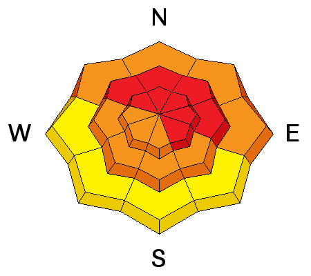
Strong winds, heavy snowfall, and lots of available snow for transport all translate to dangerous wind slab conditions. Today expect to find deep drifts 2-4' deep on the lee sides of ridge crests and terrain features. The danger will be greatest on slopes facing the north half of the compass, but with so much snow blowing around, wind slabs will have formed on all aspects wherever terrain features are able to capture drifting snow. |
| type | aspect/elevation | characteristics |
|---|

|
|
LIKELIHOOD
 LIKELY
UNLIKELY
SIZE
 LARGE
SMALL
TREND
INCREASING DANGER
SAME
DECREASING DANGER
|
|
description
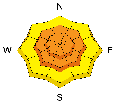
Dense new snow has formed a cohesive slab on all aspects at mid an upper elevations and avalanches within the new snow will be likely on slopes approaching 35 degrees. |
| type | aspect/elevation | characteristics |
|---|

|
|
LIKELIHOOD
LIKELY
UNLIKELY
SIZE
LARGE
SMALL
TREND
INCREASING DANGER
SAME
DECREASING DANGER
|
|
description
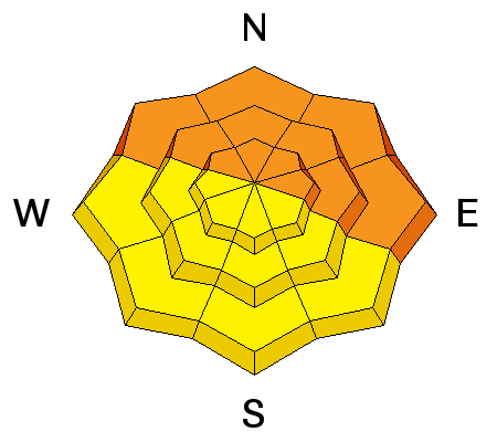
Heavy snowfall and wind loading have increased the stress on buried weak layers within the snowpack. Avalanches initiated within the new snow now have the potential to step down into these buried weak layers. In some cases this could mean stepping down to buried near surface facets that formed prior to the beginning of this last storm cycle. In other cases, it could mean stepping down to weak, faceted snow near the ground. You are most likely to encounter this type of situation in steep, rocky, heavily featured terrain where the underlying snowpack is still relatively shallow. |
 |
weather Tuesday Snow showers likely, mainly before 11am. Areas of blowing snow before 11am. Mostly cloudy, with a high near 14. Wind chill values as low as -10. Breezy, with a west northwest wind 15 to 20 mph. Chance of precipitation is 60%. New snow accumulation of 2 to 4 inches possible. Tuesday Night A 30 percent chance of snow showers before 11pm. Mostly cloudy, with a low around 3. Wind chill values as low as -15. West northwest wind around 15 mph. Wednesday Partly sunny, with a high near 13. Wind chill values as low as -10. West northwest wind around 10 mph. Wednesday Night Partly cloudy, with a low around 2. West wind around 10 mph. Thursday Partly sunny, with a high near 14. Thursday Night A 20 percent chance of snow showers. Partly cloudy, with a low around 4. Friday A slight chance of snow showers. Mostly sunny, with a high near 15. |
| general announcements Grooming: Heavy snow through the weekend will prevent grooming. If you are getting out into the mountains, we love to hear from you! You can SUBMIT OBSERVATIONS ONLINE If you would like to have avalanche advisories emailed to you, SIGN UP HERE Benefit the Utah Avalanche Center when you shop from Backcountry.com or REI: Click this link for Backcountry.com or this link to REI, shop, and they will donate a percent of your purchase price to the UAC. Both offer free shipping (with some conditions) so this costs you nothing! Benefit the Utah Avalanche Center when you sign up for AmazonSmile and designate the Utah Avalanche Center as your favorite charity, they will donate a portion of everything you spend to the UAC. I doesn't cost you a penny and we'd really appreciate the help. The information in this advisory is from the US Forest Service which is solely responsible for its content. This advisory describes general avalanche conditions and local variations always occur. |


