25th Annual Black Diamond Fall Fundraising Party
Thursday, September 13; 6:00-10:00 PM; Black Diamond Parking Lot
25th Annual Black Diamond Fall Fundraising Party
Thursday, September 13; 6:00-10:00 PM; Black Diamond Parking Lot
| Advisory: Moab Area Mountains | Issued by Eric Trenbeath for Monday - January 16, 2017 - 6:39am |
|---|


|
bottom line The avalanche danger is MODERATE today and heightened avalanche conditions exist on specific terrain features. Primary areas of concern continue to be steep, wind loaded, upper elevation slopes that face NW-N-E. Evaluate slopes carefully and avoid areas that have deep deposits of wind drifted snow. Pay special attention to slopes that have steep convexities and blind break-overs - this type of terrain can lure you far down slope, well below where an avalanche is likely to fracture.
|
 |
special announcement Backcountry 101 Avalanche Class We will be offering a Backcountry 101 avalanche class on Feb 3, 4. This course will include a night classroom session and a day in the field. Cost is $125 with proceeds to benefit the Utah Avalanche Center Moab. For more information or to sign up go here. |
 |
current conditions
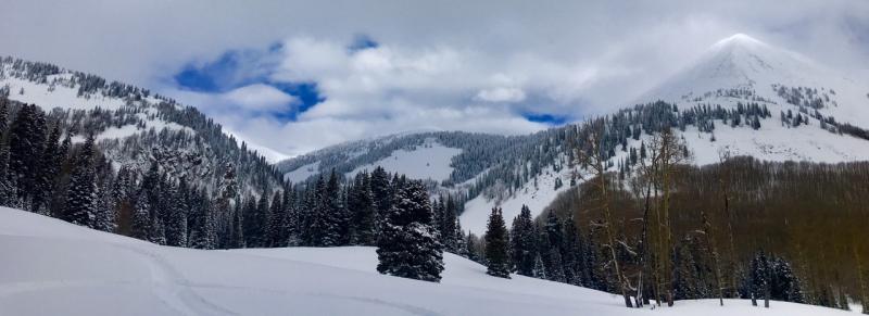
A series of storm systems last week brought close to 2' of new snow to the mountains above 10,000'. On Sunday, State Parks ranger Jeff Arbon and I took snowmobiles up over Geyser Pass where we found deep powder snow in abundance. Above tree line, winds have had their way with the snow surface, and south facing slopes are quite scoured. Winds have shifted to the NE this morning and are currently blowing in the 20-30 mph range. It's 27 degrees at the Geyser Pass Traihead and 18 on Pre Laurel Peak. Base depth in Gold Basin: 57" Storm totals and temperature in Gold Basin.(10,000') Wind, temperature and humidity on Pre Laurel Peak.(11,700') Snow totals, temperature and snow/water equivalent at the Geyser Pass Trailhead. (9600')
Lots of deep powder snow out there! |
 |
recent activity |
| type | aspect/elevation | characteristics |
|---|

|

|
LIKELIHOOD
 LIKELY
UNLIKELY
SIZE
 LARGE
SMALL
TREND
 INCREASING DANGER
SAME
DECREASING DANGER
|
|
description
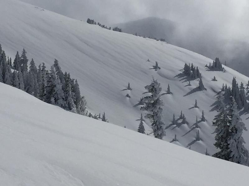
With lots of loose snow available for transport, any increase in winds will begin to move snow around creating sensitive wind slabs on the lee sides of ridge crests and terrain features in upper elevation, wind exposed terrain. It may also still be possible to trigger an older, deeper wind slab formed during the many wind and snow events of last week. These slabs will be stubborn, and are mostly welded into place by now, but I would still continue to suspect smooth, "fat" looking pillows, particularly those that have formed along steep convexities and blind break overs.
There's a lot of wind loaded looking terrain out there. Note the smooth rolls, and pillowy looking drifts. Continue to suspect slopes that look like this. |
| type | aspect/elevation | characteristics |
|---|

|

|
LIKELIHOOD
LIKELY
UNLIKELY
SIZE
 LARGE
SMALL
TREND
INCREASING DANGER
SAME
DECREASING DANGER
|
|
description
Buried layers of weak faceted snow, sometimes associated with a crust, can be found on many aspects at mid and upper elevations. How reactive they are varies from slope to slope, and about the only way you can be certain is to dig down and test them. Steep, upper elevation, wind loaded slopes that face the north half of the compass are particularly suspect. In these areas it is possible that a triggered wind slab could step down into a buried weak layer causing a deeper and more dangerous avalanche. |
 |
weather M.L.King Day Mostly cloudy, with a high near 24. North northeast wind around 10 mph. Tonight Partly cloudy, with a low around 15. North northeast wind 5 to 10 mph. Tuesday Mostly sunny, with a high near 26. East southeast wind 5 to 10 mph becoming northwest in the afternoon. Tuesday Night Mostly clear, with a low around 18. North northwest wind around 10 mph. Wednesday Sunny, with a high near 28. Northwest wind around 10 mph. Wednesday Night Partly cloudy, with a low around 18. Thursday A 40 percent chance of snow, mainly after 11am. Partly sunny, with a high near 26. Thursday Night Snow likely. Cloudy, with a low around 16. Friday Snow likely. Cloudy, with a high near 22. |
| general announcements Road Conditions: The road to Geyser Pass Trailhead is snow packed and passable to vehicles with all wheel drive. Grooming: 2-3" of snow Sunday morning covered up Saturday's grooming. If you are getting out into the mountains, we love to hear from you! You can SUBMIT OBSERVATIONS ONLINE If you would like to have avalanche advisories emailed to you, SIGN UP HERE Benefit the Utah Avalanche Center when you shop from Backcountry.com or REI: Click this link for Backcountry.com or this link to REI, shop, and they will donate a percent of your purchase price to the UAC. Both offer free shipping (with some conditions) so this costs you nothing! Benefit the Utah Avalanche Center when you buy or sell on ebay - set the Utah Avalanche Center as a favorite non-profit in your ebay account here and click on ebay gives when you buy or sell. You can choose to have your seller fees donated to the UAC, which doesn't cost you a penny. The information in this advisory is from the US Forest Service which is solely responsible for its content. This advisory describes general avalanche conditions and local variations always occur. |