25th Annual Black Diamond Fall Fundraising Party
Thursday, September 13; 6:00-10:00 PM; Black Diamond Parking Lot
25th Annual Black Diamond Fall Fundraising Party
Thursday, September 13; 6:00-10:00 PM; Black Diamond Parking Lot
| Advisory: Moab Area Mountains | Issued by Eric Trenbeath for Tuesday - January 3, 2017 - 6:54am |
|---|


|
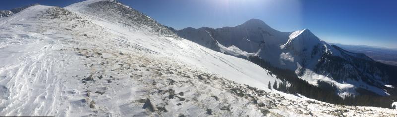
bottom line The avalanche danger is MODERATE on steep, upper-mid to upper elevation terrain that has a NW-N-E aspect, particularly in areas where there are deposits of wind drifted snow. Suspect the lee sides of ridge crests and terrain features such as sub-ridges and beneath rocky outcrops. Elsewhere, the avalanche danger is generally LOW.
|
 |
special announcement Road Update 7:30 a.am. Grand County will be closing the road between 9:00 a.m and noon to widen the road below the parking lot. |
 |
current conditions
Moderate to strong WSW winds continue to strip snow from exposed slopes, depositing it in on leeward, northerly aspects. Wind and sun exposed slopes have taken a hit, especially above tree line. Soft, settled powder can still be found on sheltered, shady slopes. Base depth in Gold Basin is 45" and the season total is 108" for 169% of normal. For a full list of recent observations go here. Storm totals and temperature in Gold Basin.(10,000') Wind, temperature and humidity on Pre Laurel Peak.(11,700') Snow totals, temperature and snow/water equivalent at the Geyser Pass Trailhead. (9600') |
 |
recent activity
This skier triggered avalanche occurred yesterday. Wind slabs such as this are the main type of problem we are dealing with right now as SW winds over the past several days have transported loose snow on to the leeward sides of terrain features such as the rock buttress in this photo. For more details go here. |
| type | aspect/elevation | characteristics |
|---|

|

|
LIKELIHOOD
 LIKELY
UNLIKELY
SIZE
 LARGE
SMALL
TREND
 INCREASING DANGER
SAME
DECREASING DANGER
|
|
description
Moderate to strong southwest winds over the past several days have been transporting snow and forming stiff, shallow wind slabs in upper elevation, wind exposed terrain, primarily on NW-NE-E aspects. Likely areas to find wind slabs are on the leeward side of ridge crests and terrain features or beneath rock buttresses. Suspect smooth rounded deposits of wind drifted snow, and avoid steep slopes that have a "fat" appearance. |
| type | aspect/elevation | characteristics |
|---|

|

|
LIKELIHOOD
 LIKELY
UNLIKELY
SIZE
 LARGE
SMALL
TREND
 INCREASING DANGER
SAME
DECREASING DANGER
|
|
description
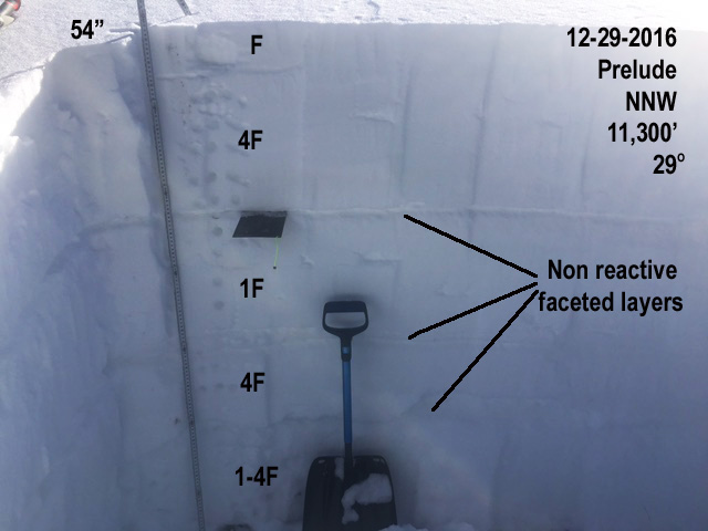
Snowpits reveal an overall stabilization and strengthening of the snowpack. Weak layers on northerly aspects, though still present, are no longer reactive under stability tests, and a facet/crust weak layer that was very reactive on southerly aspects last week has broken down. This is good news, but with the continued presence of weak layers, I would still perform a stability analysis before jumping on to any steep slope with a NW-NE-E aspect. For a full report and snowpit profile go here.
|
 |
weather Tuesday A 30 percent chance of snow, mainly after 3pm. Patchy fog after 5pm. Otherwise, partly sunny, with a high near 20. Breezy, with a west wind 15 to 25 mph, with gusts as high as 45 mph. Tonight Snow, mainly after 10pm. The snow could be heavy at times. Widespread blowing snow after 1am. Patchy fog before 9pm, then patchy fog after 10pm. Low around 18. Breezy, with a west wind 20 to 25 mph, with gusts as high as 40 mph. Chance of precipitation is 80%. New snow accumulation of 2 to 4 inches possible. Wednesday Snow. Widespread blowing snow. Areas of fog before noon. High near 24. Breezy, with a west southwest wind around 20 mph, with gusts as high as 35 mph. Chance of precipitation is 90%. New snow accumulation of 3 to 5 inches possible. Wednesday Night Snow. The snow could be heavy at times. Widespread blowing snow. Low around 20. Breezy, with a west wind 20 to 25 mph, with gusts as high as 40 mph. Chance of precipitation is 80%. New snow accumulation of 3 to 7 inches possible. Thursday Snow. The snow could be heavy at times. Widespread blowing snow, mainly after noon. High near 21. Breezy, with a west wind 15 to 20 mph, with gusts as high as 35 mph. Chance of precipitation is 80%. Thursday Night Snow, mainly before 11pm. The snow could be heavy at times. Widespread blowing snow before 11pm. Low around 10. Breezy. Chance of precipitation is 80%. Friday A 40 percent chance of snow. Partly sunny, with a high near 14. |
| general announcements Grooming: Grooming is scheduled for today. If you are getting out into the mountains, we love to hear from you! You can SUBMIT OBSERVATIONS ONLINE If you would like to have avalanche advisories emailed to you, SIGN UP HERE Benefit the Utah Avalanche Center when you shop from Backcountry.com or REI: Click this link for Backcountry.com or this link to REI, shop, and they will donate a percent of your purchase price to the UAC. Both offer free shipping (with some conditions) so this costs you nothing! Benefit the Utah Avalanche Center when you buy or sell on ebay - set the Utah Avalanche Center as a favorite non-profit in your ebay account here and click on ebay gives when you buy or sell. You can choose to have your seller fees donated to the UAC, which doesn't cost you a penny. The information in this advisory is from the US Forest Service which is solely responsible for its content. This advisory describes general avalanche conditions and local variations always occur. |