25th Annual Black Diamond Fall Fundraising Party
Thursday, September 13; 6:00-10:00 PM; Black Diamond Parking Lot
25th Annual Black Diamond Fall Fundraising Party
Thursday, September 13; 6:00-10:00 PM; Black Diamond Parking Lot
| Advisory: Moab Area Mountains | Issued by Eric Trenbeath for Saturday - December 17, 2016 - 6:01am |
|---|

|
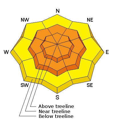
bottom line Dangerous avalanche conditions exist in the backcountry. Today the avalanche danger is CONSIDERABLE on all aspects at mid and upper elevations on slopes steeper than about 35 degrees. Human triggered avalanches are likely and backcountry travelers need to possess excellent route finding and terrain selection skills. Stick to sheltered, low angle terrain, and stay off of, and out from under steep slopes today.
|
 |
avalanche warning |
 |
special avalanche bulletin I've allowed the Avalanche Warning to expire, but heavy snow and powerful winds have created dangerous avalanche conditions. Backcountry travelers need to exercise extreme caution and possess excellent route finding and terrain management skills. |
 |
special announcement Grand County Road crew will be plowing the road to Geyser Pass Trailhead today. Thanks to them for getting up on the weekend. If you find the gate closed plowing is in progress. I wouldn't expect the road to be open until around noon today. |
 |
current conditions The mountains have received 12-16" of new snow since Thursday night with 1.5" - 2" of water under hurricane force conditions. The first wave of snow came in heavy and wet under 30-50 mph southwesterly winds creating dense, upside down snow conditions alternating with wind swept and scoured areas, particularly above tree line. The second round of snow came in last night totaling about 6" of much lower density snow and with light to moderate northwesterly winds. Sheltered, low angle terrain will be your best bet today. It's cold up there this morning at 5 degrees in Gold Basin, and winds are in the 15-20 mph range from the NW. Storm totals and temperature in Gold Basin.(10,000') Wind, temperature and humidity on Pre Laurel Peak.(11,700') Snow totals, temperature and snow/water equivalent at the Geyser Pass Trailhead.(9600') |
 |
recent activity I wasn't really able to get a good safe look around yesterday due to the intense conditions. Strong winds and poor visibility kept my route selection away from avalanche terrain, but I'd be very surprised if we did not experience natural activity during this event. |
| type | aspect/elevation | characteristics |
|---|

|
|
LIKELIHOOD
 LIKELY
UNLIKELY
SIZE
 LARGE
SMALL
TREND
 INCREASING DANGER
SAME
DECREASING DANGER
|
|
description
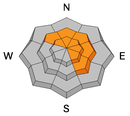
This new load of snow has been just enough to tip the scales and stress buried weak, faceted layers in our snowpack. The following video illustrates the tenuosness of the situation. Add a wind slab on top of this and you will have a very deep and dangerous avalanche. Stay off of and out from under steep slopes that have a NW-E-SE aspect. |
| type | aspect/elevation | characteristics |
|---|

|
|
LIKELIHOOD
 LIKELY
UNLIKELY
SIZE
LARGE
SMALL
TREND
 INCREASING DANGER
SAME
DECREASING DANGER
|
|
description
Strong gusty winds, and dense heavy snow have combined to make the perfect recipe for widespread wind slab development. They'll be a bit more stubborn today, but once triggered they have the potential to step down into a deeper, persistent weak layer causing a deeper and more dangerous avalanche. Recognizable by their smooth, rounded, appearance, areas of drifted snow should be avoided on slopes steeper than 30 degrees. |
| type | aspect/elevation | characteristics |
|---|

|

|
LIKELIHOOD
LIKELY
UNLIKELY
SIZE
LARGE
SMALL
TREND
INCREASING DANGER
SAME
DECREASING DANGER
|
|
description
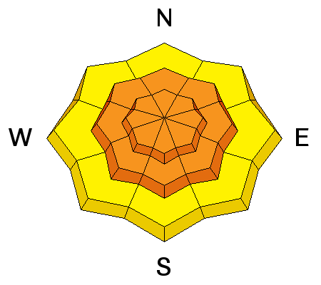
Storm snow generally takes a day or two to stabilize, and human triggered storm slab avalanches are likely today on slopes approaching 35 degrees on all aspects. |
 |
weather Saturday Snow likely, mainly before 1pm. Cloudy, then gradually becoming mostly sunny and cold, with a high near 9. Wind chill values as low as -15. Blustery, with a northwest wind 15 to 20 mph. Chance of precipitation is 60%. New snow accumulation of 1 to 3 inches possible. Saturday Night Partly cloudy, with a low around 0. Wind chill values as low as -15. West northwest wind around 10 mph. Sunday Sunny, with a high near 12. Wind chill values as low as -15. North northwest wind 5 to 10 mph. Sunday Night Mostly clear, with a low around 5. Northwest wind 5 to 10 mph. Monday Sunny, with a high near 20. |


