25th Annual Black Diamond Fall Fundraising Party
Thursday, September 13; 6:00-10:00 PM; Black Diamond Parking Lot
25th Annual Black Diamond Fall Fundraising Party
Thursday, September 13; 6:00-10:00 PM; Black Diamond Parking Lot
| Advisory: Moab Area Mountains | Issued by Eric Trenbeath for Sunday - December 11, 2016 - 6:25am |
|---|

|
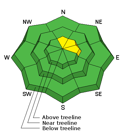
bottom line The avalanche danger is generally LOW this morning but areas of unstable snow may exist on isolated terrain features, particularly in upper elevation, wind exposed terrain that has a N-NE-E aspect. Continue to practice safe travel techniques and evaluate suspect terrain for smooth, rounded deposits of wind drifted snow on the leeward sides of upper elevation ridge crests and terrain features.
|
 |
special announcement I'll be presenting a free Know Before You go avalanche awareness talk next Thursday, December 15, at the Grand County Library at 6:00 p.m. The presentation includes an exciting and educational video produced by the Utah Avalanche Center that has been chosen as an official selection in the Banff Mountain Film Festival. Following will be a powerpoint presentation, and a question and answer session on staying safe in the winter backcountry.Hope to see you there! |
 |
current conditions My confidence in forecasted snow totals was low to begin with, but the final results even under exceeded my expectations. That is to say that only trace amounts of snow fell overnight. Snow conditions have taken a turn for the worse over the past week, and most surfaces are now wind scoured or crusted. Some soft snow can still be found in sheltered areas and the base is still mostly supportable, but it's thin, and weeds, rocks and dead fall are becoming more apparent. Southwesterly ridge top winds have been blowing in the 25-30 mph range for the past 24 hours with gusts into the 40's. They backed off around 3:00 a.m. shifting to northwesterly, and are currently averaging 15-20 mph. It's 20 degrees on Pre Laurel Peak and 29 at the Geyser Pass Trailhead. Storm totals and temperature in Gold Basin.(10,000') Wind, temperature and humidity on Pre Laurel Peak.(11,700') Snow totals, temperature and snow/water equivalent at the Geyser Pass Trailhead.(9600')
It's starting to look pretty thin out there with plenty of weeds sticking out and exposed rocks on the peaks. |
| type | aspect/elevation | characteristics |
|---|

|
|
LIKELIHOOD
 LIKELY
UNLIKELY
SIZE
 LARGE
SMALL
TREND
 INCREASING DANGER
SAME
DECREASING DANGER
|
|
description
The avalanche danger is generally low this morning but recently deposited wind slabs may exist on isolated terrain features, particularly in upper elevation, wind exposed terrain that has a N-NE-E aspect. Continue to practice safe travel techniques and evaluate suspect terrain for smooth, rounded deposits of wind drifted snow on the leeward sides of upper elevation ridge crests and terrain features. |
 |
weather We'll see some lingering clouds and a chance of precipitation, possibly in the form of freezing rain today as the current system exits the area. On Monday there will be a lull in the "action" before an unsettled pattern returns with the possibility of snow starting late Tuesday and extending through the weekend. Today Snow and freezing rain likely before 10am, then a chance of freezing rain between 10am and 4pm. Partly sunny, with a high near 24. Windy, with a west wind 20 to 30 mph, with gusts as high as 45 mph. Chance of precipitation is 70%. Total daytime ice accumulation of less than a 0.1 of an inch possible. Total daytime snow accumulation of less than a half inch possible. Tonight Partly cloudy, with a low around 20. Breezy, with a west wind 20 to 25 mph, with gusts as high as 45 mph. Monday Partly sunny, with a high near 26. Breezy, with a west wind 15 to 20 mph, with gusts as high as 35 mph. Monday Night Mostly cloudy, with a low around 19. West wind around 15 mph, with gusts as high as 30 mph. Tuesday A 40 percent chance of snow. Widespread blowing snow after 11am. Mostly cloudy, with a high near 26. Breezy, with a west southwest wind 15 to 20 mph, with gusts as high as 35 mph. Tuesday Night A 40 percent chance of snow. Mostly cloudy, with a low around 23. Breezy. Wednesday A 30 percent chance of snow. Mostly cloudy, with a high near 29. Breezy. Wednesday Night A slight chance of snow. Mostly cloudy, with a low around 27. Breezy. Thursday Snow likely, mainly after 11am. Mostly cloudy, with a high near 31. Breezy. Thursday Night Snow likely. Cloudy, with a low around 22. Windy. Friday Snow likely. Mostly cloudy, with a high near 22. Breezy. |
| general announcements The road to Geyser Pass Trailhead is plowed and clear but slick. Grooming of cross country trails has commenced for the season and the lower meadow and road into Gold Basin was groomed on Thursday. |


