25th Annual Black Diamond Fall Fundraising Party
Thursday, September 13; 6:00-10:00 PM; Black Diamond Parking Lot
25th Annual Black Diamond Fall Fundraising Party
Thursday, September 13; 6:00-10:00 PM; Black Diamond Parking Lot
| Advisory: Moab Area Mountains | Issued by Eric Trenbeath for Saturday - December 10, 2016 - 6:57am |
|---|

|
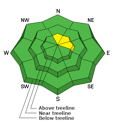
bottom line The avalanche danger is generally LOW this morning but areas of unstable snow may exist on isolated terrain features, particularly in upper elevation, wind exposed terrain that has a N-NE-E aspect. Continue to practice safe travel techniques and evaluate suspect terrain for smooth, rounded deposits of wind drifted snow on the leeward sides of upper elevation ridge crests and terrain features.
|
 |
special announcement I'll be presenting a free Know Before You go avalanche awareness talk next Thursday, December 15, at the Grand County Library at 6:00 p.m. The presentation includes an exciting and educational video produced by the Utah Avalanche Center that has been chosen as an official selection in the Banff Mountain Film Festival. Following will be a powerpoint presentation, and a question and answer session on staying safe in the winter backcountry.Hope to see you there! |
 |
current conditions The glory days of last weekend have come and gone and wind, sun, and cold clear nights have begun to erode our shallow early, season snowpack. That's not to say that it's all over but you'll need to stick to the trees and sheltered areas to find soft powder snow. The base is still mostly supportable, but it's thin, and weeds, rocks and deadfall are becoming more apparent. Southwest winds have been on the increase since about midnight and are blowing in the 20-30 mph range with gusts into the 40's along ridge tops. Temperatures are warm and it's 25 degrees on Pre Laurel Peak and 35 at the Geyser Pass Trailhead. Storm totals and temperature in Gold Basin.(10,000') Wind, temperature and humidity on Pre Laurel Peak.(11,700') Snow totals, temperature and snow/water equivalent at the Geyser Pass Trailhead.(9600')
It's starting to look pretty thin out there with plenty of weeds sticking out and exposed rocks on the peaks. |
| type | aspect/elevation | characteristics |
|---|

|
|
LIKELIHOOD
 LIKELY
UNLIKELY
SIZE
 LARGE
SMALL
TREND
 INCREASING DANGER
SAME
DECREASING DANGER
|
|
description
The avalanche danger is generally low this morning but recently deposited wind slabs may exist on isolated terrain features, particularly in upper elevation, wind exposed terrain that has a N-NE-E aspect. Continue to practice safe travel techniques and evaluate suspect terrain for smooth, rounded deposits of wind drifted snow on the leeward sides of upper elevation ridge crests and terrain features. |
 |
weather An active storm system tracking to the north will drop south through the central mountains of Colorado this evening. We'll be left on the backside of the energy, but we may be able to squeak a few inches of snow out of it by Sunday morning. Today Snow likely, mainly after 3pm. Partly sunny, with a high near 30. Windy, with a west wind 25 to 30 mph, with gusts as high as 45 mph. Chance of precipitation is 60%. Total daytime snow accumulation of less than one inch possible. Tonight Snow. The snow could be heavy at times. Widespread blowing snow between 10pm and 4am. Patchy fog between 2am and 4am. Low around 19. Windy, with a west wind 25 to 30 mph, with gusts as high as 50 mph. Chance of precipitation is 80%. New snow accumulation of 4 to 8 inches possible. Sunday Snow likely, mainly before 10am. Cloudy, then gradually becoming mostly sunny, with a high near 24. Breezy, with a west northwest wind 15 to 20 mph, with gusts as high as 35 mph. Chance of precipitation is 70%. New snow accumulation of 1 to 2 inches possible. Sunday Night Partly cloudy, with a low around 17. Breezy, with a west wind 15 to 20 mph, with gusts as high as 35 mph. Monday Mostly sunny, with a high near 24. Breezy, with a west wind 15 to 20 mph, with gusts as high as 30 mph. |
| general announcements The road to Geyser Pass Trailhead is plowed and clear but slick. Grooming of cross country trails has commenced for the season and the lower meadow and road into Gold Basin was groomed on Thursday. |


