25th Annual Black Diamond Fall Fundraising Party
Thursday, September 13; 6:00-10:00 PM; Black Diamond Parking Lot
25th Annual Black Diamond Fall Fundraising Party
Thursday, September 13; 6:00-10:00 PM; Black Diamond Parking Lot
| Advisory: Moab Area Mountains | Issued by Eric Trenbeath for Saturday - December 3, 2016 - 6:20am |
|---|

|
bottom line The avalanche danger is MODERATE on steep upper elevation slopes that have areas of wind drifted snow. There is also a MODERATE danger for triggering a deeper, persistent slab in upper elevation, north facing terrain. Elsewhere the avalanche danger is generally LOW.
|
 |
special announcement |
 |
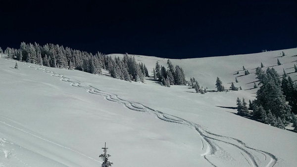
current conditions Flurries yesterday produced a little over an inch of new, low density snow. Ridge top winds have been light, and all over the compass the past 24 hours. They are currently blowing in the 10-15 mph range from the WSW. It's 8 degrees on Pre Laurel Peak and 4 in Gold Basin. Good powder conditions over a supportable base can still be found below tree line and in sheltered alpine bowls, but the early season snow pack remains shallow, and rocks and dead fall lurk just beneath the surface. Above tree line, winds have affected the snow surface in exposed areas, and some south facing slopes have developed a thin crust. Average snow depth is 24"-36". Storm totals and temperature in Gold Basin.(10,000') Wind, temperature and humidity on Pre Laurel Peak.(11,700') Snow totals, temperature and snow/water equivalent at the Geyser Pass Trailhead.(9600')
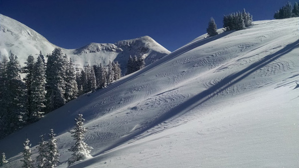
From nothing on the ground two weeks ago to this. Not bad for early December.
Snow is wind affected above tree line.
But drop down below, and it's powder! |
| type | aspect/elevation | characteristics |
|---|

|

|
LIKELIHOOD
 LIKELY
UNLIKELY
SIZE
 LARGE
SMALL
TREND
 INCREASING DANGER
SAME
DECREASING DANGER
|
|
description
Winds slabs formed earlier in the week are stabilizing and will be stubborn to trigger. But the high country is plastered with drifts and pillows on the lee sides of ridge crests and terrain features. Many of them are located further down slope requiring commitment beyond the point of no return to investigate. For a long and healthy season, avoid steep, wind drifted, upper elevation terrain. |
| type | aspect/elevation | characteristics |
|---|

|

|
LIKELIHOOD
LIKELY
UNLIKELY
SIZE
LARGE
SMALL
TREND
INCREASING DANGER
SAME
DECREASING DANGER
|
|
description
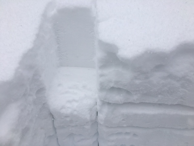
So far we have the makings of what Western Uintah forecaster Craig Gordon is calling a "designer snow pack." With virtually no snow on the ground prior to the first 9" storm on 11-16, we've had a succession of storms pile up in short order that have given us an instant snow pack 24"-36" deep. The snow pack is "right side up" meaning it gets progressively denser near the bottom. Of note are some early stage basal facets, or sugary weak snow near the ground. Though not currently reactive, their development will likely increase over the next week with the coming cold temperatures and periodic clear nights. I've also been able to tease out a weak layer that sheers, but doesn't propagate mid way down in the pack. These things aren't currently huge red flags, but you'll want to investigate the snow pack before committing to steep, upper elevation, northerly facing terrain.
Sheers like this continue to show up but they aren't propagating. |
 |
weather Dry and seasonally cool weather is expected to persist through Sunday. The next winter storm system remains on track for the first half of next week. Although this storm system will bring frigid temperatures to the area on Tuesday and Wednesday, the latest model runs suggest this weather system may not be a big snow producer Today Mostly sunny, with a high near 21. North northwest wind 10 to 15 mph. Tonight Mostly clear, with a low around 14. North wind 10 to 15 mph. Sunday Sunny, with a high near 28. North wind 5 to 10 mph becoming west in the afternoon. Sunday Night Mostly cloudy, with a low around 17. Breezy, with a west southwest wind 10 to 20 mph, with gusts as high as 30 mph. Monday Partly sunny, with a high near 23. Breezy, with a west wind 15 to 20 mph, with gusts as high as 30 mph. Monday Night A 20 percent chance of snow. Partly cloudy, with a low around 8. |
| general announcements The road to Geyser Pass Trailhead is plowed and clear. Grooming of cross country trails has commenced for the season. Kirstin and Travis got things packed out and rolled into Gold Basin and through the lower meadow on Thursday. |