25th Annual Black Diamond Fall Fundraising Party
Thursday, September 13; 6:00-10:00 PM; Black Diamond Parking Lot
25th Annual Black Diamond Fall Fundraising Party
Thursday, September 13; 6:00-10:00 PM; Black Diamond Parking Lot
| Advisory: Logan Area Mountains | Issued by Paige Pagnucco for Tuesday - April 3, 2018 - 6:49am |
|---|

|
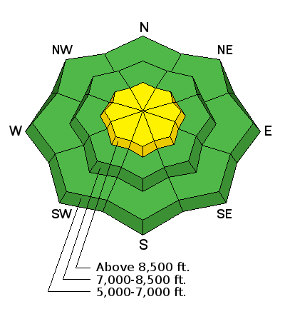
bottom line The avalanche danger is MODERATE as heightened avalanche conditions exist on steep, upper elevation slopes affected by recent strong westerly winds. Avoid steep slopes with freshly wind-drifted snow, especially near ridgelines. Stay well back from cornices as they can break further back than you expect. At low and mid elevations, the avalanche danger is generally LOW. I will update this advisory by 7:30 Wednesday morning, 4/4/18.
|
 |
special announcement The newest issue of the Powder Cloud, the newsletter of the Utah Avalanche Center is hot off the presses. You can always grab a cup of coffee and while away the time by looking at new and old issues of the Powder Cloud, other essays, and blogs. Look for them in the menu above or click here.
The UAC Marketplace is still open. Our online marketplace still has deals on skis, packs, airbag packs, beacons, snowshoes, soft goods and much more. |
 |
current conditions Sustained strong westerly winds were the story yesterday. Despite getting 4-6" of new snow, the snow surface is now very firm on most aspects and elevations as temperatures reverted back to winter and winds blasted the new as well as any remaining loose snow. Riding conditions are supportable though trailhead access is melting out at Tony Grove, Franklin Basin and Beaver Creek. The best option for today is to stay on lower angle, sheltered terrain well below the ridgelines where you'll have the best chance at finding a few inches of softer new snow.
|
 |
recent activity An observer noted significant wet avalanche activity in the Pine Canyon area of the Wellsvilles Sunday. He noted several natural slides and was able as well to trigger several himself. Some of these ran hundreds of vertical feet and piled up quite deeply. I observed some small, loose wet avalanches on an east facing 8900' slope Sunday in the Steam Mill Peak area. |
| type | aspect/elevation | characteristics |
|---|

|
|
LIKELIHOOD
 LIKELY
UNLIKELY
SIZE
 LARGE
SMALL
TREND
 INCREASING DANGER
SAME
DECREASING DANGER
|
|
description
Yesterday's strong westerly winds combined with new snow have created heightened avalanche conditions on upper elevation slopes, especially along ridgelines and in and around terrain features. Human-triggered wind slabs up to a foot deep are possible on steep, exposed slopes where freshly drifted snow has accumulated. Avoid steep slopes that look smooth and rounded and chalky. Cornices are a by-product of strong winds - stay well back from them as they can break back further than you expect. |
| type | aspect/elevation | characteristics |
|---|

|
|
LIKELIHOOD
 LIKELY
UNLIKELY
SIZE
LARGE
SMALL
TREND
INCREASING DANGER
SAME
DECREASING DANGER
|
|
description
A few things to keep in mind if you're headed into the backcountry:
|
 |
weather Despite being April 3, today will be a classic winter bluebird day with plenty of sunshine, unseasonably cool temps and light westerly winds. An unsettled pattern moves in for the rest of the week. A stronger system looks promising for the weekend. Today: Sunny, with a high near 29. Wind chill values as low as -6. West wind 7 to 10 mph. Check out this cool satellite imagery tool from Colorado State (subtract 6 hours to get local time). |
| general announcements We have lift tickets for Snowbasin and Powder Mountain remaining. The tickets are discounted an additional 20%. Details and order information here. All proceeds from these go towards paying for avalanche forecasting and education! Episode 7 of the UAC Podcast "Mastery and False Mastery - An Interview with 'Big' Don Sharaf" is live. With a snow career spanning over 30 years, Don has enough mileage in the mountains to have learned a thing or two, including the profound value of humility when staring into the face of the dragon. Listen in on our conversation about the idea of mastery and if such a thing can exist in the avalanche world. Check it out on the UAC blog, ITunes, Stitcher, or wherever you get your podcasts. The UAC has new support programs with Outdoor Research and Darn Tough. Support the UAC through your daily shopping. When you shop at Smith's, or online at Outdoor Research, REI, Backcountry.com, Darn Tough, Patagonia, NRS, Amazon, eBay a portion of your purchase will be donated to the FUAC. See our Donate Page for more details on how you can support the UAC when you shop. Benefit the Utah Avalanche Center when you buy or sell on eBay - set the Utah Avalanche Center as a favorite non-profit in your eBay account here and click on eBay gives when you buy or sell. You can choose to have your seller fees donated to the UAC, which doesn't cost you a penny Check it out on ITunes, Stitcher, the UAC blog, or wherever you get your podcasts. Now is a great time to practice companion rescue techniques with your backcountry partners. Here's our rescue practice video. EMAIL ADVISORY: If you would like to get the daily advisory by email you will need to subscribe here. Remember your information can save lives. If you see anything we should know about, please help us out by submitting snow and avalanche observations. You can also call us at 801-524-5304, email by clicking HERE, or include #utavy in your Instagram. This advisory is from the U.S.D.A. Forest Service, which is solely responsible for its content. This advisory describes general avalanche conditions and local variations always occur. |