25th Annual Black Diamond Fall Fundraising Party
Thursday, September 13; 6:00-10:00 PM; Black Diamond Parking Lot
25th Annual Black Diamond Fall Fundraising Party
Thursday, September 13; 6:00-10:00 PM; Black Diamond Parking Lot
| Advisory: Logan Area Mountains | Issued by Toby Weed for Saturday - March 24, 2018 - 7:15am |
|---|

|
bottom line Heightened avalanche conditions and MODERATE danger exist in the backcountry today. Human triggered cornice falls and wind slab avalanches are possible in drifted upper elevation terrain. Thursday's heavy rain saturated the snow, and large wet slab and loose wet avalanches remain possible today, especially in steep mid elevation terrain.
I will update this advisory by 7:30 Monday morning, 3/26/18.
|
 |
special announcement We have lift tickets for Snowbasin and Powder Mountain remaining. The tickets are discounted an additional 20%. Details and order information here. All proceeds from these go towards paying for avalanche forecasting and education! |
 |
current conditions You might find decent powder riding conditions at upper elevations, but heightened avalanche conditions exist and human triggered avalanches are possible on many slopes in the backcountry. A good solid freeze tonight will solidify the saturated snow at lower and mid elevations and increase snow stability.
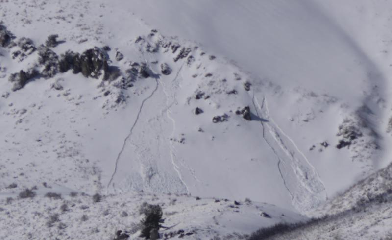
Loose wet avalanches were comon yesterday in the Wellsville Mountain Wilderness. |
 |
recent activity
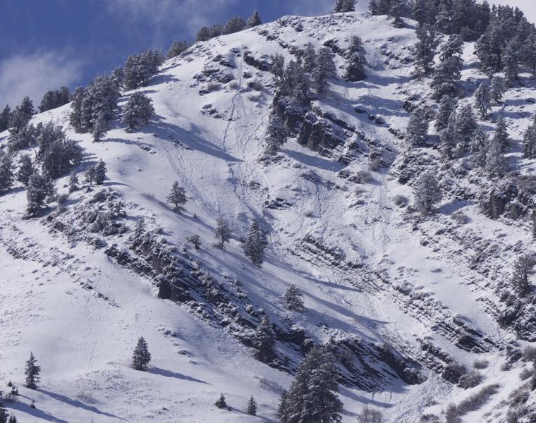
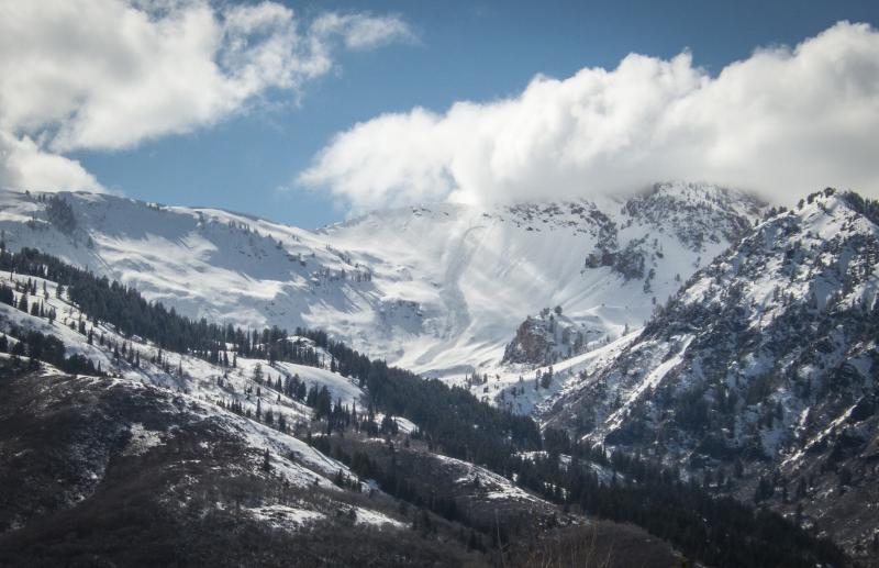
A sizable natural avalanche was visible yesterday on the Willard Peak Headwall above the Ogden Valley. |
| type | aspect/elevation | characteristics |
|---|

|
|
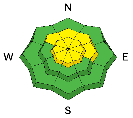
LIKELIHOOD
 LIKELY
UNLIKELY
SIZE
 LARGE
SMALL
TREND
 INCREASING DANGER
SAME
DECREASING DANGER
|
|
description
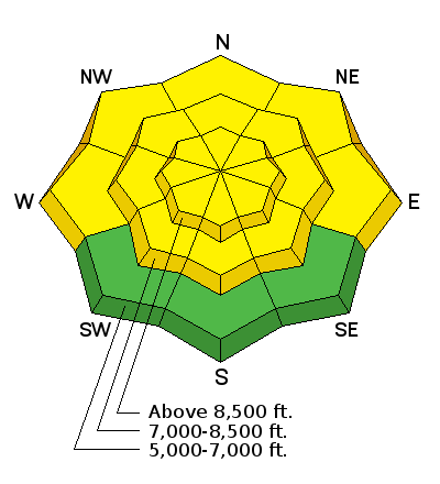
South winds picked up overnight, drifting snow into lee slope avalanche starting zones and building cornices. Human triggered wind slab avalanches and cornice falls are possible in drifted terrain at upper elevations.
|
| type | aspect/elevation | characteristics |
|---|

|
|
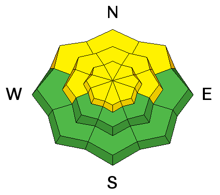
LIKELIHOOD
LIKELY
UNLIKELY
SIZE
 LARGE
SMALL
TREND
 INCREASING DANGER
SAME
DECREASING DANGER
|
|
description
Thursday's rain added weight to the snowpack and weakened the existing structure. Dangerous wet and/or persistent deep slab avalanches are possible in steep terrain with saturated shallow snow and in drifted areas with preexisting poor snow structure.
|
| type | aspect/elevation | characteristics |
|---|

|
|
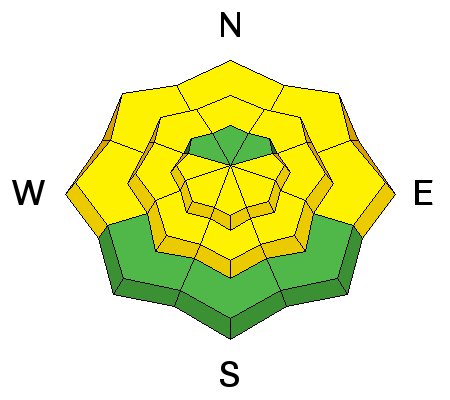
LIKELIHOOD
LIKELY
UNLIKELY
SIZE
LARGE
SMALL
TREND
INCREASING DANGER
SAME
DECREASING DANGER
|
|
description
Natural and triggered loose wet avalanches are possible as mountain temperatures warm up during the day after rain saturated the snow. Loose wet avalanches entraining significant piles of saturated surface snow are likely in steep terrain, especially on mid-elevation slopes facing the northern half of the compass. Cooler temperatures will help, but backcountry snow at all but the highest elevations in the Logan Zone is saturated and prone to producing dangerous wet avalanches.
Natural loose wet avalanches entraining fresh snow in the Wellsvilles yesterday. |
 |
weather The broad area of high pressure aloft across the western states will generate a warming trend across Utah through the end of the week.
|
| general announcements Episode 7 of the UAC Podcast "Mastery and False Mastery - An Interview with 'Big' Don Sharaf" is live. With a snow career spanning over 30 years, Don has enough mileage in the mountains to have learned a thing or two, including the profound value of humility when staring into the face of the dragon. Listen in on our conversation about the idea of mastery and if such a thing can exist in the avalanche world. Check it out on the UAC blog, ITunes, Stitcher, or wherever you get your podcasts. The UAC Marketplace is still open. Our online marketplace still has deals on skis, packs, airbag packs, beacons, snowshoes, soft goods and much more. The UAC has new support programs with Outdoor Research and Darn Tough. Support the UAC through your daily shopping. When you shop at Smith's, or online at Outdoor Research, REI, Backcountry.com, Darn Tough, Patagonia, NRS, Amazon, eBay a portion of your purchase will be donated to the FUAC. See our Donate Page for more details on how you can support the UAC when you shop. Benefit the Utah Avalanche Center when you buy or sell on eBay - set the Utah Avalanche Center as a favorite non-profit in your eBay account here and click on eBay gives when you buy or sell. You can choose to have your seller fees donated to the UAC, which doesn't cost you a penny Check it out on ITunes, Stitcher, the UAC blog, or wherever you get your podcasts. Now is a great time to practice companion rescue techniques with your backcountry partners. Here's our rescue practice video. EMAIL ADVISORY: If you would like to get the daily advisory by email you will need to subscribe here. Remember your information can save lives. If you see anything we should know about, please help us out by submitting snow and avalanche observations. You can also call us at 801-524-5304, email by clicking HERE, or include #utavy in your Instagram. This advisory is from the U.S.D.A. Forest Service, which is solely responsible for its content. This advisory describes general avalanche conditions and local variations always occur. |