25th Annual Black Diamond Fall Fundraising Party
Thursday, September 13; 6:00-10:00 PM; Black Diamond Parking Lot
25th Annual Black Diamond Fall Fundraising Party
Thursday, September 13; 6:00-10:00 PM; Black Diamond Parking Lot
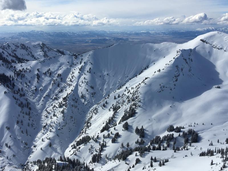
| Advisory: Logan Area Mountains | Issued by Toby Weed for Saturday - March 17, 2018 - 7:11am |
|---|

|
bottom line There is MODERATE danger in the backcountry. Heightened avalanche conditions exist, and human triggered cornice falls and wind slab avalanches around a foot deep are possible in drifted terrain.
|
 |
special announcement Episode 7 of the UAC Podcast "Mastery and False Mastery - An Interview with 'Big' Don Sharaf" is live. With a snow career spanning over 30 years, Don has enough mileage in the mountains to have learned a thing or two, including the profound value of humility when staring into the face of the dragon. Listen in on our conversation about the idea of mastery and if such a thing can exist in the avalanche world. Check it out on the UAC blog, ITunes, Stitcher, or wherever you get your podcasts. |
 |
current conditions South and southwest winds picked up significantly overnight, and a a few more inches of snow fell in the mountains. Heightened avalanche conditions exist, with human triggered wind slab avalanches around a foot deep possible at upper and mid elevations. More dangerous persistent slab avalanches are unlikely yet still possible in isolated areas with shallow weak snow.
|
 |
recent activity We noticed a few small wet loose surface sluffs on very steep south and west facing slopes in the Mt Naomi Wilderness, and riders triggered a few small loose dry sluffs in steep north facing terrain yesterday. Otherwise no other avalanche activity was observed or reported.
Very dangerous avalanche conditions exist in the Central Utah mountains, as confirmed Thursday by UAC staff on the Manti Skyline.... |
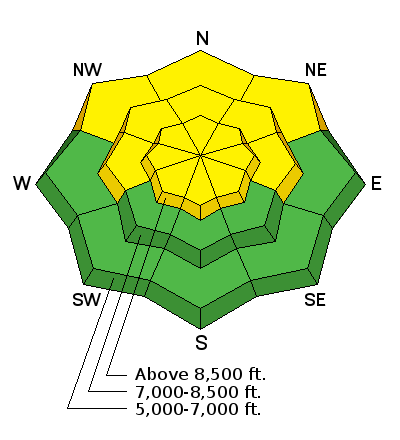
| type | aspect/elevation | characteristics |
|---|

|
|
LIKELIHOOD
 LIKELY
UNLIKELY
SIZE
 LARGE
SMALL
TREND
 INCREASING DANGER
SAME
DECREASING DANGER
|
|
description
Continuing southwest wind will drift last night's fresh snow in exposed terrain, and cause a rising danger of wind slab avalanches and cornice falls. Human triggered wind slab avalanches around a foot deep are possible in drifted terrain at upper and mid elevations.
|
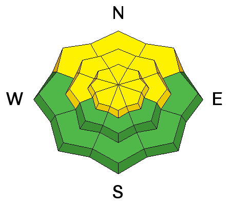
| type | aspect/elevation | characteristics |
|---|

|
|
LIKELIHOOD
 LIKELY
UNLIKELY
SIZE
 LARGE
SMALL
TREND
 INCREASING DANGER
SAME
DECREASING DANGER
|
|
description
Heightened persistent slab avalanche conditions exist in areas with shallow snow and poor snow structure. Colder temperatures are helping, but some areas with shallow snow cover have very poor snow structure. I've found suspect conditions on steep forested slopes, rocky terrain, and outlying or rarely visited areas. |
 |
weather
|
| general announcements We have discount lift tickets for Alta, Snowbird, Brighton, Solitude, Snowbasin,and Beaver Mountain. Details and order information here. All proceeds from these go towards paying for avalanche forecasting and education! The UAC Marketplace is still open. Our online marketplace still has deals on skis, packs, airbag packs, beacons, snowshoes, soft goods and much more. The UAC has new support programs with Outdoor Research and Darn Tough. Support the UAC through your daily shopping. When you shop at Smith's, or online at Outdoor Research, REI, Backcountry.com, Darn Tough, Patagonia, NRS, Amazon, eBay a portion of your purchase will be donated to the FUAC. See our Donate Page for more details on how you can support the UAC when you shop. Benefit the Utah Avalanche Center when you buy or sell on eBay - set the Utah Avalanche Center as a favorite non-profit in your eBay account here and click on eBay gives when you buy or sell. You can choose to have your seller fees donated to the UAC, which doesn't cost you a penny Check it out on ITunes, Stitcher, the UAC blog, or wherever you get your podcasts. Now is a great time to practice companion rescue techniques with your backcountry partners. Here's our rescue practice video. EMAIL ADVISORY: If you would like to get the daily advisory by email you will need to subscribe here. Remember your information can save lives. If you see anything we should know about, please help us out by submitting snow and avalanche observations. You can also call us at 801-524-5304, email by clicking HERE, or include #utavy in your Instagram. This advisory is from the U.S.D.A. Forest Service, which is solely responsible for its content. This advisory describes general avalanche conditions and local variations always occur. |