25th Annual Black Diamond Fall Fundraising Party
Thursday, September 13; 6:00-10:00 PM; Black Diamond Parking Lot
25th Annual Black Diamond Fall Fundraising Party
Thursday, September 13; 6:00-10:00 PM; Black Diamond Parking Lot
| Advisory: Logan Area Mountains | Issued by Toby Weed for Thursday - March 15, 2018 - 7:01am |
|---|

|
bottom line There is MODERATE danger in the backcountry. Heightened avalanche conditions exist, and human triggered avalanches are possible.
|
 |
current conditions Temperatures dropped a few degrees below freezing at all stations overnight, and a several inches of snow fell in the mountains. A few more inches of snow is expected today, with forecast temperatures hovering just below freezing. An increasing moderate southwest wind will drift the fresh snow at upper elevations into lee slope avalanche starting zones. Heightened avalanche conditions exist, with human triggered storm snow, wind slab, loose wet, and more dangerous persistent slab avalanches possible.
|
 |
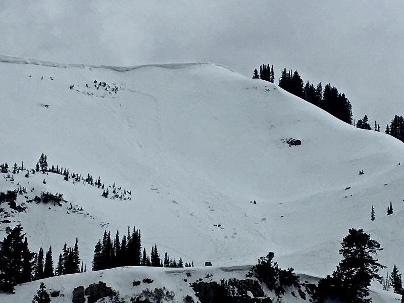
recent activity In the past couple very warm days, natural wet loose avalanches have been running off the mountains in the Logan Zone like hot candle wax.
Natural wet avalanche activity on the west face of Cherry Peak, 3/13/18 Yesterday, I found what looks a recent natural avalanche off Providence Peak in 3 Terraces Bowl. The 2' deep. 100' wide persistent slab avalanche was a few days old. It appears to have been naturally triggered by cornice fall.
|
| type | aspect/elevation | characteristics |
|---|

|
|
LIKELIHOOD
 LIKELY
UNLIKELY
SIZE
 LARGE
SMALL
TREND
 INCREASING DANGER
SAME
DECREASING DANGER
|
|
description
Shallow soft slabs and loose avalanches involving last night's storm snow are possible, mainly at upper elevations. Increasing moderate southwest wind will drift the fresh snow in exposed terrain, and cause a rising danger of wind slab avalanches and cornice falls.
|
| type | aspect/elevation | characteristics |
|---|

|

|
LIKELIHOOD
LIKELY
UNLIKELY
SIZE
 LARGE
SMALL
TREND
 INCREASING DANGER
SAME
DECREASING DANGER
|
|
description
Heightened persistent slab avalanche conditions exist in areas with shallow snow and poor snow structure. The warmth from the past several days softened the slab layer, increased the creep and glide rate of the snow, and moistened up weak sugary faceted layers.
|
| type | aspect/elevation | characteristics |
|---|

|

|
LIKELIHOOD
LIKELY
UNLIKELY
SIZE
 LARGE
SMALL
TREND
 INCREASING DANGER
SAME
DECREASING DANGER
|
|
description
Cooler temperatures will help, but snow is still soft and saturated in some areas. Natural and triggered loose wet avalanches are possible at lower and mid elevations.
|
 |
weather The broad area of high pressure aloft across the western states will generate a warming trend across Utah through the end of the week.
|
| general announcements We have discount lift tickets for Alta, Snowbird, Brighton, Solitude, Snowbasin,and Beaver Mountain. Details and order information here. All proceeds from your purchase go towards paying for avalanche forecasting and education. Episode 6 of the UAC podcast "A Conversation with Tom Kimbrough, Hemingway of the Wasatch" is live. We explore ideas about lifetime exposure to risk and what role Buddhism has played in his life as a climber, skier, and soon-to-be octogenarian. We talk about what has changed over the years in snow science and the role of mentorship in the world of avalanche forecasting and other professions and pursuits. Check it out on ITunes, Stitcher, the UAC blog. The UAC Marketplace is online. The holiday auction is closed, but our online marketplace still has deals on skis, packs, airbag packs, beacons, snowshoes, soft goods and much more. The UAC has new support programs with Outdoor Research and Darn Tough. Support the UAC through your daily shopping. When you shop at Smith's, or online at Outdoor Research, REI, Backcountry.com, Darn Tough, Patagonia, NRS, Amazon, eBay a portion of your purchase will be donated to the FUAC. See our Donate Page for more details on how you can support the UAC when you shop. Benefit the Utah Avalanche Center when you buy or sell on eBay - set the Utah Avalanche Center as a favorite non-profit in your eBay account here and click on eBay gives when you buy or sell. You can choose to have your seller fees donated to the UAC, which doesn't cost you a penny Check it out on ITunes, Stitcher, the UAC blog, or wherever you get your podcasts. Now is a great time to practice companion rescue techniques with your backcountry partners. Here's our rescue practice video. EMAIL ADVISORY: If you would like to get the daily advisory by email you will need to subscribe here. Remember your information can save lives. If you see anything we should know about, please help us out by submitting snow and avalanche observations. You can also call us at 801-524-5304, email by clicking HERE, or include #utavy in your Instagram. This advisory is from the U.S.D.A. Forest Service, which is solely responsible for its content. This advisory describes general avalanche conditions and local variations always occur. |