25th Annual Black Diamond Fall Fundraising Party
Thursday, September 13; 6:00-10:00 PM; Black Diamond Parking Lot
25th Annual Black Diamond Fall Fundraising Party
Thursday, September 13; 6:00-10:00 PM; Black Diamond Parking Lot
| Advisory: Logan Area Mountains | Issued by Toby Weed for Monday - January 29, 2018 - 7:25am |
|---|

|
bottom line Heightened avalanche conditions exist in the backcountry. Dangerous human-triggered persistent slab avalanches are possible on steep slopes with poor snow structure, as are loose wet avalanches at lower elevations and in sunny terrain.
|
 |
special announcement The UAC Marketplace is online. The holiday auction is closed, but our online marketplace still has deals on skis, packs, airbag packs, beacons, snowshoes, soft goods and much more. |
 |
current conditions The Tony Grove Snotel at 8400' reports 28°F, and there's 60 inches of total snow at the site containing 91% of normal SWE (or Snow Water Equivalent). It's 26°F at UDOT Hwy 89 Logan Summit and a northwest wind is blowing around 10 mph this morning. Light freezing rain Saturday night formed a brittle, translucent crust on the snow surface, capping all of last week's nice powder like creme brulee. Heightened avalanche conditions continue to exist on many slopes and dangerous human triggered persistent slab avalanches are possible.
A rime (icing) event occurred Saturday night, capping all the nice powder with a creme brulee crust. |
 |
recent activity No avalanches were reported recently in the Logan Zone. A skier was caught carried and injured by an avalanche in Big Cottonwood Canyon in the Wasatch Range on Friday, 1/26/18. Here's Trent's video: |
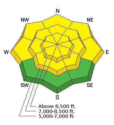
| type | aspect/elevation | characteristics |
|---|

|
|
LIKELIHOOD
 LIKELY
UNLIKELY
SIZE
 LARGE
SMALL
TREND
 INCREASING DANGER
SAME
DECREASING DANGER
|
|
description
Dangerous triggered persistent slab avalanches remain possible on steep slopes, especially those with shallow snow and poor snow structure. Widespread faceted layers appear dormant currently, but a new load from the recent storm may reactivate buried weak layers in some areas, especially on drifted lee slopes.
|
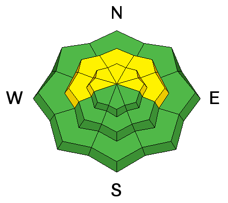
| type | aspect/elevation | characteristics |
|---|

|
|
LIKELIHOOD
 LIKELY
UNLIKELY
SIZE
 LARGE
SMALL
TREND
 INCREASING DANGER
SAME
DECREASING DANGER
|
|
description
Warm temperatures and plenty of sun will create heightened wet avalanche conditions today at lower elevations and in sunny terrain.
|
 |
weather High pressure will maintain a very mild airmass across the region through Tuesday. A dry cold front will cross the area Tuesday night into Wednesday. High pressure will slowly return late in the week through the upcoming weekend.
|
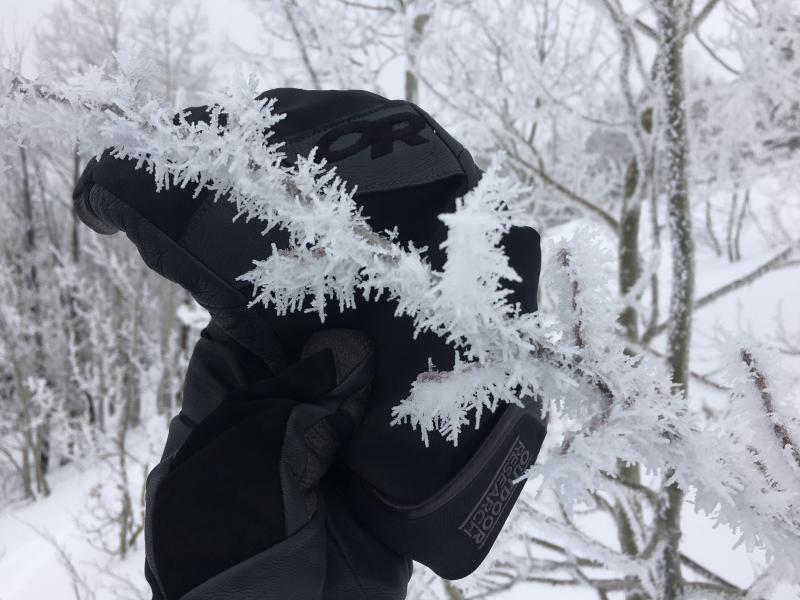
| general announcements We have discount lift tickets for Alta, Snowbird, Brighton, Solitude, Snowbasin,and Beaver Mountain. Details and order information here. All proceeds from these go towards paying for avalanche forecasting and education! The UAC has new support programs with Outdoor Research and Darn Tough. Support the UAC through your daily shopping. When you shop at Smith's, or online at Outdoor Research, REI, Backcountry.com, Darn Tough, Patagonia, NRS, Amazon, eBay a portion of your purchase will be donated to the FUAC. See our Donate Page for more details on how you can support the UAC when you shop. Benefit the Utah Avalanche Center when you buy or sell on eBay - set the Utah Avalanche Center as a favorite non-profit in your eBay account here and click on eBay gives when you buy or sell. You can choose to have your seller fees donated to the UAC, which doesn't cost you a penny Episode 3 of the UAC podcast is live. We talk with UDOT Avalanche Program Supervisor Bill Nalli on how he and his teams keep the Greatest Snow on Earth from avalanching over the open roads and highways of the state. Check it out on ITunes, Stitcher, the UAC blog, or wherever you get your podcasts. Now is a great time to practice companion rescue techniques with your backcountry partners. Here's our rescue practice video. EMAIL ADVISORY: If you would like to get the daily advisory by email you will need to subscribe here. Remember your information can save lives. If you see anything we should know about, please help us out by submitting snow and avalanche observations. You can also call us at 801-524-5304, email by clicking HERE, or include #utavy in your tweet or Instagram. This advisory is from the U.S.D.A. Forest Service, which is solely responsible for its content. This advisory describes general avalanche conditions and local variations always occur. |