25th Annual Black Diamond Fall Fundraising Party
Thursday, September 13; 6:00-10:00 PM; Black Diamond Parking Lot
25th Annual Black Diamond Fall Fundraising Party
Thursday, September 13; 6:00-10:00 PM; Black Diamond Parking Lot
| Advisory: Logan Area Mountains | Issued by Toby Weed for Thursday - January 25, 2018 - 7:07am |
|---|

|
bottom line Dangerous wind slab avalanche conditions exist on drifted upper elevation slopes in the backcountry. Drifting from continuing strong southwest winds today will cause the danger to increase and become more widespread. Scary persistent slab avalanches are possible on very steep shady slopes and in rocky areas with shallow snow.
|
 |
special announcement The UAC has new support programs with Outdoor Research and Darn Tough. Support the UAC through your daily shopping. When you shop at Smith's, or online at Outdoor Research, REI, Backcountry.com, Darn Tough, Patagonia, NRS, Amazon, eBay a portion of your purchase will be donated to the FUAC. See our Donate Page for more details on how you can support the UAC when you shop. |
 |
current conditions The Tony Grove Snotel at 8400' reports an inch or two of new snow overnight. It's 33°F, and there's 53 inches of total snow at the site containing 89% of normal SWE (Snow Water Equivalent). It's 25°F at the CSI Logan Peak weather station, with 35 mph wind, but the wind direction sensor still appears iced. South winds increased overnight on Ogden Peak and are currently blowing around 60 mph, with a recent gust of 76 mph. Expect strong southwest winds to continue today and snowfall to increase this afternoon. Drifting snow will cause a rising avalanche danger in the backcountry today. Dangerous wind slab avalanche conditions already exist at upper elevations and will continue to develop and become more widespread in exposed terrain. |
 |
recent activity A skier was caught, deployed an airbag, and was partially buried by an avalanche he triggered in the backcountry above Park City yesterday. Report In the Logan Zone:
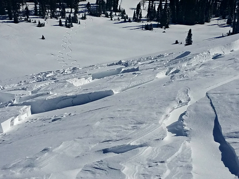
Chunks of drifted snow in a small natural wind slab avalanche observed in the Franklin Basin Area yesterday. |
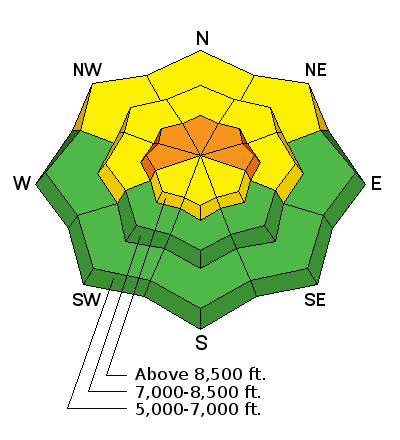
| type | aspect/elevation | characteristics |
|---|

|
|
LIKELIHOOD
 LIKELY
UNLIKELY
SIZE
 LARGE
SMALL
TREND
 INCREASING DANGER
SAME
DECREASING DANGER
|
|
description
Wind slab avalanches, made up of drifted snow are likely in exposed upper elevation terrain. Strong and continuing southwest winds and snow today will create fresh wind slabs, which are likely be sensitive to human triggering.
|
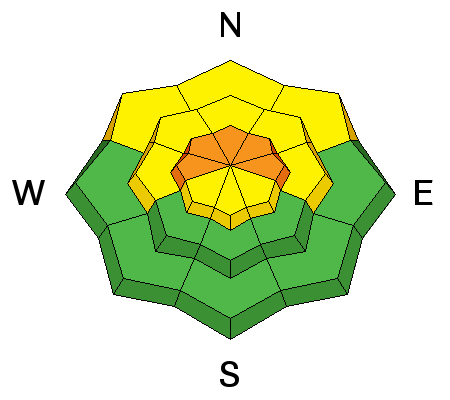
| type | aspect/elevation | characteristics |
|---|

|
|
LIKELIHOOD
 LIKELY
UNLIKELY
SIZE
 LARGE
SMALL
TREND
INCREASING DANGER
SAME
DECREASING DANGER
|
|
description
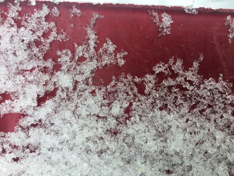
Snowpit tests still show propagation and slab failure on buried weak layers made up of sugary, faceted December snow. Dangerous persistent slab avalanches remain possible on very steep slopes with shallow snow and poor snow structure. On Tuesday, I triggered collapsing and found suspect shallow and weak snow conditions in the trees on a northwest facing slope. Yesterday, we wallowed around in knee-deep loose facets in the Dog Leg Trees area in Providence Canyon.
Paige took pictures of these well developed and chained facets, which are widespread in Providence Canyon (1/24/18). |
 |
weather A storm system along the West Coast will weaken as it approaches. The associated cold front will sweep across the area today. High pressure will return for the upcoming weekend and early next week.
|
| general announcements Benefit the Utah Avalanche Center when you buy or sell on eBay - set the Utah Avalanche Center as a favorite non-profit in your eBay account here and click on eBay gives when you buy or sell. You can choose to have your seller fees donated to the UAC, which doesn't cost you a penny Episode 3 of the UAC podcast is live. We talk with UDOT Avalanche Program Supervisor Bill Nalli on how he and his teams keep the Greatest Snow on Earth from avalanching over the open roads and highways of the state. Check it out on ITunes, Stitcher, the UAC blog, or wherever you get your podcasts. We have discount lift tickets for Alta, Snowbird, Brighton, Solitude, Snowbasin,and Beaver Mountain. Details and order information here. All proceeds from these go towards paying for avalanche forecasting and education! The UAC Marketplace is online. The holiday auction is closed, but our online marketplace still has deals on skis, packs, airbag packs, beacons, snowshoes, soft goods and much more. Now is a great time to practice companion rescue techniques with your backcountry partners. Here's our rescue practice video. EMAIL ADVISORY: If you would like to get the daily advisory by email you will need to subscribe here. Remember your information can save lives. If you see anything we should know about, please help us out by submitting snow and avalanche observations. You can also call us at 801-524-5304, email by clicking HERE, or include #utavy in your tweet or Instagram. This advisory is from the U.S.D.A. Forest Service, which is solely responsible for its content. This advisory describes general avalanche conditions and local variations always occur. |