25th Annual Black Diamond Fall Fundraising Party
Thursday, September 13; 6:00-10:00 PM; Black Diamond Parking Lot
25th Annual Black Diamond Fall Fundraising Party
Thursday, September 13; 6:00-10:00 PM; Black Diamond Parking Lot
| Advisory: Logan Area Mountains | Issued by Toby Weed for Monday - January 22, 2018 - 7:05am |
|---|

|
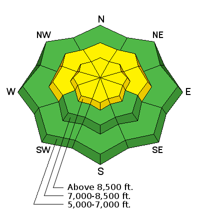
bottom line Heightened avalanche conditions exist in the backcountry, and the danger is MODERATE. Human-triggered avalanches are possible at upper and mid elevations. Pockets with more dangerous persistent slab avalanche conditions exist in shallow rocky areas and in some outlying terrain with poor snow structure.
|
 |
special announcement We are offering a Backcountry 101 Avalanche Awareness class in Logan this Thursday evening and Saturday. If you've ever wanted to learn about avalanche safety or perhaps want to refresh your skills, this is a great opportunity. Details and registration online. |
 |
current conditions The Tony Grove Snotel at 8400' reports 13°F, and there's 54 inches of total snow at the site containing 91% of normal SWE (Snow Water Equivalent). It's -3°F at the UDOT Hwy 89 Logan Summit weather station, with mostly calm winds. Pockets with dangerous persistent slab avalanche conditions exist in shallow areas with poor snow structure. Over the weekend, a couple parties reported audible collapses and shallow snowpacks with very poor snow structure at mid elevations in the northern Bear River Range west of Bear Lake. I also found poor snow structure and triggered a couple good sized collapses or whumpfing noises and some deep shooting cracks as I traveled along the Stump Hollow/Beaver Creek Canyon ridge yesterday. |
 |
recent activity No new avalanches were reported in the Logan Zone in the past week. |
| type | aspect/elevation | characteristics |
|---|

|
|
LIKELIHOOD
 LIKELY
UNLIKELY
SIZE
 LARGE
SMALL
TREND
 INCREASING DANGER
SAME
DECREASING DANGER
|
|
description
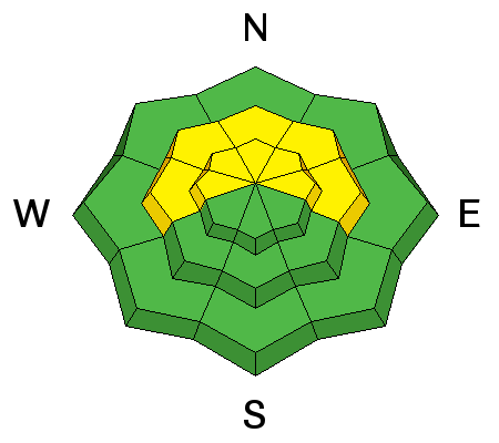
Dangerous persistent slab avalanches, 2 to 3 feet deep, are possible on slopes with shallow snow and poor snow structure. Slopes with poor snow structure are most common in shallow rocky areas at mid elevations, but areas with shallow snow at upper elevations are also suspect. Lower elevation snow on slopes facing the northern half of the compass is very weak, consisting of sugary faceted snow capped by rain crusts. But in most areas, it lacks a slab.
|
| type | aspect/elevation | characteristics |
|---|

|
|
LIKELIHOOD
LIKELY
UNLIKELY
SIZE
 LARGE
SMALL
TREND
 INCREASING DANGER
SAME
DECREASING DANGER
|
|
description
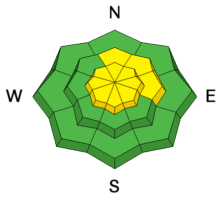
Wind slab avalanches, made up of drifted snow from the weekend storm are possible in exposed upper and mid elevation terrain. Increasing southwest winds today will create fresh wind slabs.
|
 |
weather A weak system will graze northern Utah today. High pressure aloft will return midweek with a second stronger and colder storm expected late in the week.
|
| general announcements We're excited to introduce for the 2017/2018 winter the Utah Avalanche Center podcast, hosted by forecaster Drew Hardesty and produced by KUER's Benjamin Bombard. The podcast will include engaging stories, interviews, and lessons learned - all things avalanche to help keep people on top of the snow instead of buried beneath it - and easily found on ITunes, Stitcher, the UAC blog, or wherever you get your podcasts. Discount lift tickets for Alta, Snowbird, Brighton, Solitude, Deer Valley, Snowbasin, and Beaver Mountain are now available, donated by the resorts to benefit the Utah Avalanche Center. Details and order information here. All proceeds go towards paying for avalanche forecasting and education! Now is a great time to practice companion rescue techniques with your backcountry partners. Here's our rescue practice video. Go HERE for a list of UAC classes. EMAIL ADVISORY: If you would like to get the daily advisory by email you will need to subscribe here. Benefit the Utah Avalanche Center when you shop from Backcountry.com or REI: Click this link for Backcountry.com or this link to REI, shop, and they will donate a percent of your purchase price to the UAC. Both offer free shipping (with some conditions) so this costs you nothing! Benefit the Utah Avalanche Center when you buy or sell on ebay - set the Utah Avalanche Center as a favorite non-profit in your ebay account here and click on ebay gives when you buy or sell. You can choose to have your seller fees donated to the UAC, which doesn't cost you a penny. Remember your information can save lives. If you see anything we should know about, please help us out by submitting snow and avalanche observations. You can also call us at 801-524-5304, email by clicking HERE, or include #utavy in your tweet or Instagram. This advisory is from the U.S.D.A. Forest Service, which is solely responsible for its content. This advisory describes general avalanche conditions and local variations always occur. |


