25th Annual Black Diamond Fall Fundraising Party
Thursday, September 13; 6:00-10:00 PM; Black Diamond Parking Lot
25th Annual Black Diamond Fall Fundraising Party
Thursday, September 13; 6:00-10:00 PM; Black Diamond Parking Lot
| Advisory: Logan Area Mountains | Issued by Toby Weed for Wednesday - January 10, 2018 - 7:02am |
|---|

|
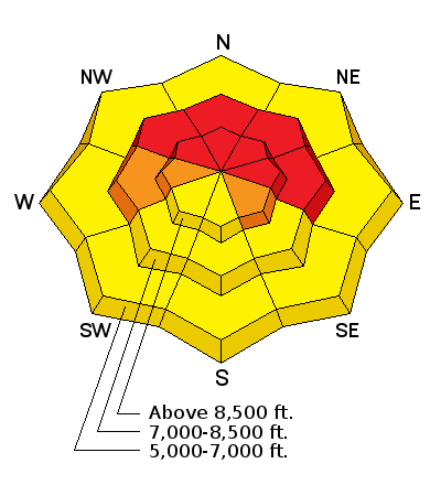
bottom line Dangerous avalanche conditions exist on many slopes in the backcountry, and with heavy snow and drifting from westerly winds, the danger will rise to HIGH today in many areas.
|
 |
avalanche warning THE FOREST SERVICE UTAH AVALANCHE CENTER IN SALT LAKE CITY HAS ISSUED A BACKCOUNTRY AVALANCHE WARNING. * TIMING…IN EFFECT FROM 6 AM MST THIS MORNING TO 6 AM MST THURSDAY * AFFECTED AREA…FOR THE MOUNTAINS OF NORTHERN AND CENTRAL UTAH INCLUDING THE WASATCH RANGE...PROVO AREA MOUNTAINS...BEAR RIVER RANGE...WESTERN UINTA MOUNTAINS...WASATCH PLATEAU/MANTI SKYLINE...FISH LAKE AREA MOUNTAINS.... * AVALANCHE DANGER…THE AVALANCHE DANGER IS HIGH. * IMPACTS…HEAVY SNOW HAS OVERLOADED THE PREEXISTING WEAK SNOW PACK. THE AVALANCHE DANGER IS HIGH AND BOTH HUMAN TRIGGERED AND NATURAL AVALANCHES ARE LIKELY. TRAVEL IN AVALANCHE TERRAIN IS NOT RECOMMENDED. AVALANCHES CAN BE TRIGGERED FROM A DISTANCE AND FROM BELOW. STAY OFF OF AND OUT FROM UNDER SLOPES STEEPER THAN 30 DEGREES. BACKCOUNTRY TRAVELERS SHOULD CONSULT WWW.UTAHAVALANCHECENTER.ORG OR CALL 1-888-999-4019 FOR MORE DETAILED INFORMATION. THIS WARNING DOES NOT APPLY TO SKI AREAS WHERE AVALANCHE HAZARD REDUCTION MEASURES ARE PERFORMED. |
 |
current conditions The Tony Grove Snotel at 8400' reportes about 6 inches of heavy new snow, and temperatures are dropping, now 31°F. There's 47 inches of total snow containing 98% of normal SWE (Snow Water Equivalent). It's 32°F at the UDOT Hwy 89 Summit weather station, with 10 to 15 mph wind, from the west-northwest. Temperatures, snow line, and snow densities should all gradually drop during the day. Dangerous avalanche conditions exist on many slopes in the backcountry, and with heavy snow and drifting from westerly winds, the danger will continue to rise today.
|
 |
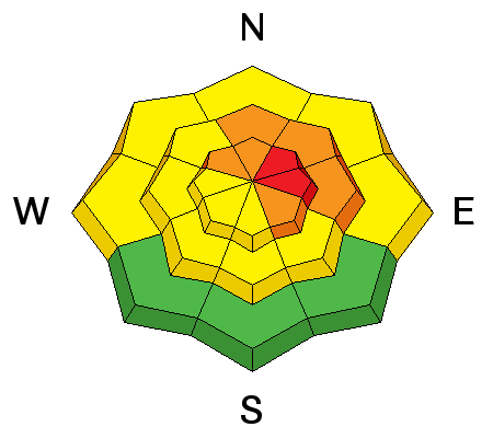
recent activity We have reports of numerous recent intentionally human triggered wet and persistent slab avalanches, most with avalanche reduction programs at the various ski areas in the northern and central Wasatch Mountains |
| type | aspect/elevation | characteristics |
|---|

|

|
LIKELIHOOD
 LIKELY
UNLIKELY
SIZE
 LARGE
SMALL
TREND
 INCREASING DANGER
SAME
DECREASING DANGER
|
|
description
Dangerous persistent slab avalanches are possible, and conditions are likely to get much more dangerous today on slopes with poor snow structure, which exist in many areas. Sugary faceted snow is so weak in some areas that only a few additional inches of snow today might be enough to cause avalanches.
|
| type | aspect/elevation | characteristics |
|---|

|
|
LIKELIHOOD
 LIKELY
UNLIKELY
SIZE
 LARGE
SMALL
TREND
INCREASING DANGER
SAME
DECREASING DANGER
|
|
description
Increasing westerly winds are drifting fresh snow in exposed terrain, depositing it on leeward slopes and in and around terrain features. Wind slab avalanches consisting of drifted fresh snow are possible, especially where last week's surface snow was exceptionally weak. Drifting snow will form dangerous wind slab avalanche conditions in exposed upper elevation terrain today.
|
| type | aspect/elevation | characteristics |
|---|

|

|
LIKELIHOOD
LIKELY
UNLIKELY
SIZE
LARGE
SMALL
TREND
 INCREASING DANGER
SAME
DECREASING DANGER
|
|
description
Rain on the weak snow at lower and mid-elevations has created dangerous wet avalanche conditions. Triggered loose wet avalanches or sluffs, entraining all of the saturated loose sugary snow on the ground, are likely, and dangerous wet slab avalanches are possible on mid-elevation slopes where rain saturated snow with poor structure.
|
 |
weather The upper low tracking east across Arizona will maintain light precipitation across portions of southern and eastern Utah this morning. A second weather disturbance will cross northern and central Utah today. A moist westerly flow aloft will remain across northern Utah through Friday, followed by a drying and warming trend for the weekend.
|
| general announcements Discount lift tickets for Alta, Snowbird, Brighton, Solitude, Deer Valley, Snowbasin, and Beaver Mountain are now available, donated by the resorts to benefit the Utah Avalanche Center. Details and order information here. All proceeds go towards paying for avalanche forecasting and education! We're excited to introduce for the 2017/2018 winter the Utah Avalanche Center podcast, hosted by forecaster Drew Hardesty and produced by KUER's Benjamin Bombard. The podcast will include engaging stories, interviews, and lessons learned - all things avalanche to help keep people on top of the snow instead of buried beneath it - and easily found on ITunes, Stitcher, the UAC blog, or wherever you get your podcasts. Now is a great time to practice companion rescue techniques with your backcountry partners. Here's our rescue practice video. Go HERE for a list of UAC classes. EMAIL ADVISORY: If you would like to get the daily advisory by email you will need to subscribe here. Benefit the Utah Avalanche Center when you shop from Backcountry.com or REI: Click this link for Backcountry.com or this link to REI, shop, and they will donate a percent of your purchase price to the UAC. Both offer free shipping (with some conditions) so this costs you nothing! Benefit the Utah Avalanche Center when you buy or sell on ebay - set the Utah Avalanche Center as a favorite non-profit in your ebay account here and click on ebay gives when you buy or sell. You can choose to have your seller fees donated to the UAC, which doesn't cost you a penny. Remember your information can save lives. If you see anything we should know about, please help us out by submitting snow and avalanche observations. You can also call us at 801-524-5304, email by clicking HERE, or include #utavy in your tweet or Instagram. This advisory is from the U.S.D.A. Forest Service, which is solely responsible for its content. This advisory describes general avalanche conditions and local variations always occur. |


