25th Annual Black Diamond Fall Fundraising Party
Thursday, September 13; 6:00-10:00 PM; Black Diamond Parking Lot
25th Annual Black Diamond Fall Fundraising Party
Thursday, September 13; 6:00-10:00 PM; Black Diamond Parking Lot
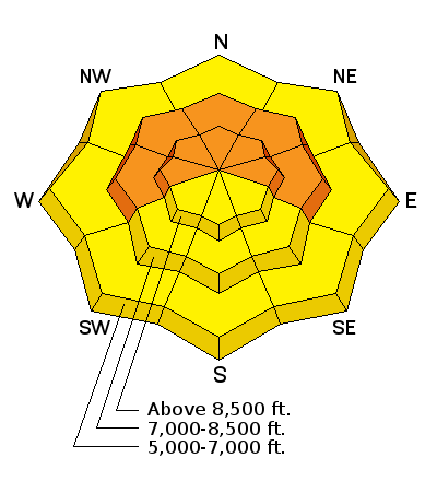
| Advisory: Logan Area Mountains | Issued by Toby Weed for Tuesday - January 9, 2018 - 7:05am |
|---|

|
bottom line Avalanche conditions will get more dangerous today, as rain, heavy snow, warm temperatures, and strengthening wind create a slab overloading widespread weak sugary or faceted snow. Rain on weak snow at lower elevations will cause heightened wet avalanche conditions. The overall danger could rise to CONSIDERABLE, with triggered avalanches likely on some slopes by afternoon.
|
 |
avalanche watch THE FOREST SERVICE UTAH AVALANCHE CENTER IN SALT LAKE CITY HAS ISSUED A BACKCOUNTRY AVALANCHE WATCH. * TIMING...FROM 0600 MST THIS MORNING UNTIL 0600 MST WEDNESDAY MORNING. * AFFECTED AREA...THE MOUNTAINS OF NORTHERN UTAH INCLUDING THE WASATCH RANGE, PROVO AREA MOUNTAINS, BEAR RIVER RANGE, WESTERN UINTAS MOUNTAINS, WASATCH PLATEAU/MANTI SKYLINE, AND THE FISH LAKE AREA MOUNTAINS. * AVALANCHE DANGER...THE AVALANCHE DANGER FOR THESE AREAS WILL BE RISING SIGNIFICANTLY WITH ADDITIONAL SNOW AND WIND. THE AVALANCHE DANGER COULD REACH HIGH BY WEDNESDAY. * REASON/IMPACTS...HEAVY SNOW COMBINED WITH STRONG WIND WILL LEAD TO VERY DANGEROUS AVALANCHE CONDITIONS. NATURAL AND HUMAN TRIGGERED AVALANCHES ARE LIKELY. AVALANCHES MAY BE TRIGGERED FROM BELOW, SO STAY OFF OF AND OUT FROM UNDERNEATH STEEP MOUNTAIN SLOPES. BACKCOUNTRY TRAVELERS SHOULD CONSULT WWW.UTAHAVALANCHECENTER.ORG OR CALL 1-888-999-4019 FOR MORE DETAILED INFORMATION. THIS WATCH DOES NOT APPLY TO SKI AREAS WHERE AVALANCHE HAZARD REDUCTION MEASURES ARE PERFORMED. |
 |
current conditions The Tony Grove Snotel at 8400' reportes 1 inch of new snow early this morning, and it's 33°F. There's 44 inches of total snow containing 96% of normal SWE (Snow Water Equivalent). It's 27°F at the 9700' CSI Logan Peak weather station, with 25 mph south wind, and gusts around 42 mph. A moist and rather mild storm will bring rain to lower elevations and heavy snow up high today. The avalanche danger will increase during the day, and dangerous conditions are likely to develop in some areas.
|
 |
recent activity No avalanches were reported over the weekend, but one party reports triggering a large collapse or whumpfing sound, which indicates instability. The second person in the party to cross the slab up-track initiated the collapse on a west facing slope above Swan Flat Rd at around 8600'. There was a close call on 12/26/17, a very lucky 20-year-old rider was rescued by his party after being caught, carried, mostly buried, and pinned against a tree in Boss Canyon near the Idaho State Line in the Franklin Basin Area. View the Report |
| type | aspect/elevation | characteristics |
|---|

|
|
LIKELIHOOD
 LIKELY
UNLIKELY
SIZE
 LARGE
SMALL
TREND
 INCREASING DANGER
SAME
DECREASING DANGER
|
|
description
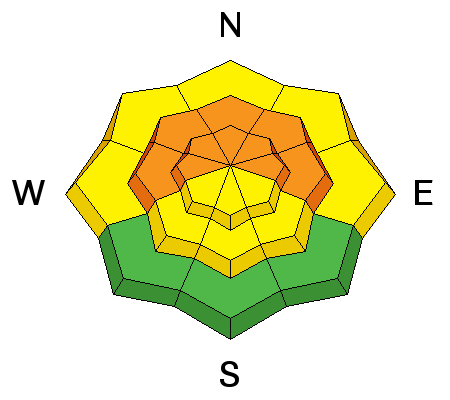
Dangerous persistent slab avalanches are possible, and conditions are likely to get more dangerous today on slopes with poor snow structure, which exist in many areas. Sugary faceted snow is so weak in some areas that only a few inches of moist snow today might be enough to cause avalanches.
|
| type | aspect/elevation | characteristics |
|---|

|
|
LIKELIHOOD
 LIKELY
UNLIKELY
SIZE
 LARGE
SMALL
TREND
INCREASING DANGER
SAME
DECREASING DANGER
|
|
description
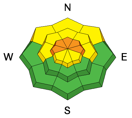
Increasing south and southwest winds are drifting fresh snow in exposed terrain, depositing it on leeward slopes and in and around terrain features. Wind slab avalanches consisting of drifted fresh snow are possible, especially where last week's surface snow was exceptionally weak. Drifting snow could form dangerous wind slab avalanche conditions in exposed upper elevation terrain today.
|
| type | aspect/elevation | characteristics |
|---|

|
|
LIKELIHOOD
LIKELY
UNLIKELY
SIZE
 LARGE
SMALL
TREND
INCREASING DANGER
SAME
DECREASING DANGER
|
|
description
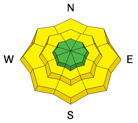
Rain on the weak snow at lower and perhaps mid-elevations will cause heightened wet avalanche conditions. Stay out from under steep slopes with saturated snow. |
 |
weather The low pressure system currently off the southern California coast will track east across the desert southwest tonight through early Wednesday. A second system will enter northern Utah early Wednesday, bringing much colder air and snow to northern and central Utah through Wednesday evening.
|
| general announcements Discount lift tickets for Alta, Snowbird, Brighton, Solitude, Deer Valley, Snowbasin, and Beaver Mountain are now available, donated by the resorts to benefit the Utah Avalanche Center. Details and order information here. All proceeds go towards paying for avalanche forecasting and education! We're excited to introduce for the 2017/2018 winter the Utah Avalanche Center podcast, hosted by forecaster Drew Hardesty and produced by KUER's Benjamin Bombard. The podcast will include engaging stories, interviews, and lessons learned - all things avalanche to help keep people on top of the snow instead of buried beneath it - and easily found on ITunes, Stitcher, the UAC blog, or wherever you get your podcasts. Now is a great time to practice companion rescue techniques with your backcountry partners. Here's our rescue practice video. Go HERE for a list of UAC classes. EMAIL ADVISORY: If you would like to get the daily advisory by email you will need to subscribe here. Benefit the Utah Avalanche Center when you shop from Backcountry.com or REI: Click this link for Backcountry.com or this link to REI, shop, and they will donate a percent of your purchase price to the UAC. Both offer free shipping (with some conditions) so this costs you nothing! Benefit the Utah Avalanche Center when you buy or sell on ebay - set the Utah Avalanche Center as a favorite non-profit in your ebay account here and click on ebay gives when you buy or sell. You can choose to have your seller fees donated to the UAC, which doesn't cost you a penny. Remember your information can save lives. If you see anything we should know about, please help us out by submitting snow and avalanche observations. You can also call us at 801-524-5304, email by clicking HERE, or include #utavy in your tweet or Instagram. This advisory is from the U.S.D.A. Forest Service, which is solely responsible for its content. This advisory describes general avalanche conditions and local variations always occur. |


